Arc-lès-Gray (Arc-lès-Gray)

- commune in Haute-Saône, France
- Country:

- Postal Code: 70100
- Coordinates: 47° 27' 25" N, 5° 35' 8" E


- GPS tracks (wikiloc): [Link]
- AboveSeaLevel: 192 м m
- Area: 12.1 sq km
- Population: 2530
- Web site: http://www.arc-les-gray.com
- Wikipedia en: wiki(en)
- Wikipedia: wiki(fr)
- Wikidata storage: Wikidata: Q630946
- Wikipedia Commons Category: [Link]
- Freebase ID: [/m/03nt0zw]
- GeoNames ID: Alt: [3037263]
- SIREN number: [217000264]
- BnF ID: [15272420v]
- VIAF ID: Alt: [245831133]
- INSEE municipality code: 70026
Shares border with regions:


Rigny
- commune in Haute-Saône, France
- Country:
- Postal Code: 70100
- Coordinates: 47° 28' 21" N, 5° 37' 59" E
- GPS tracks (wikiloc): [Link]
- Area: 12.72 sq km
- Population: 595
- Web site: [Link]
Nantilly
- commune in Haute-Saône, France
- Country:
- Postal Code: 70100
- Coordinates: 47° 27' 32" N, 5° 31' 37" E
- GPS tracks (wikiloc): [Link]
- Area: 10 sq km
- Population: 487
Chargey-lès-Gray
- commune in Haute-Saône, France
- Country:
- Postal Code: 70100
- Coordinates: 47° 29' 15" N, 5° 34' 31" E
- GPS tracks (wikiloc): [Link]
- Area: 16.56 sq km
- Population: 726


Mantoche
- commune in Haute-Saône, France
- Country:
- Postal Code: 70100
- Coordinates: 47° 25' 10" N, 5° 31' 51" E
- GPS tracks (wikiloc): [Link]
- Area: 16.58 sq km
- Population: 457
- Web site: [Link]
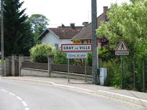

Gray-la-Ville
- commune in Haute-Saône, France
- Country:
- Postal Code: 70100
- Coordinates: 47° 26' 22" N, 5° 34' 22" E
- GPS tracks (wikiloc): [Link]
- Area: 3.97 sq km
- Population: 968
- Web site: [Link]