Argentera (Argentera)
- Italian comune
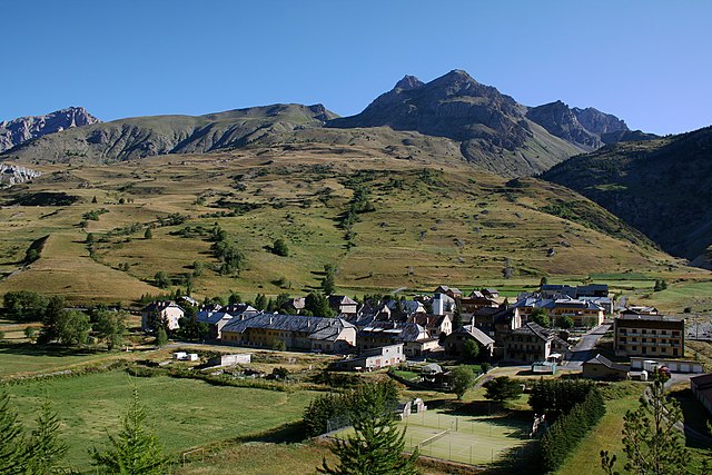
 Hiking in Argentera
Argentera is a beautiful area located in the Piedmont region of Italy, within the Maritime Alps. It is well-known for its stunning landscapes, diverse flora and fauna, and a wide range of hiking trails suitable for all skill levels. Here are some details about hiking in Argentera:
Scenic Beauty
- Mountain Landscapes: The region features dramatic mountain scenery, including jagged peaks, lush valleys, and pristine alpine lakes. The views from the trails are often breathtaking, making it a photographer's paradise.
- Wildlife: Hikers may encounter various wildlife species, including ibex, chamois, marmots, and a variety of birds. The natural environment is rich in biodiversity.
Hiking Trails
- Variety of Routes: Argentera offers a diverse selection of trails. Some are suitable for families and beginners, while others challenge experienced hikers. Popular routes include:
- Colle di Fenestrelle: A classic hike with excellent views of the surrounding mountains.
- Lago delle Portette: A scenic trek leading to a beautiful glacial lake.
- Sentiero dei Ghiacciai: This trail takes you through areas with visible glaciers and impressive rock formations.
Tips for Hiking in Argentera
- Trail Preparation: Research trails in advance. Ensure you have a map or a hiking app with GPS functionality, as some routes can be less marked.
- Weather: The weather can change rapidly in the mountains, so check forecasts and be prepared for varying conditions. Bring suitable clothing and gear.
- Water and Supplies: Carry enough water and snacks, as some trails can be long and remote. Hydration is essential, especially at higher altitudes.
- Safety: Inform someone about your hiking plans and estimated return time. Hike with a buddy when possible, and consider local regulations concerning wildlife and environmental preservation.
Access and Facilities
- Getting There: Argentera is accessible by car, and there are public transport options from nearby towns. The nearest larger town is Cuneo, where you can find additional services.
- Accommodations: Services such as lodges, alpine huts, and camping areas are available for those wishing to extend their stay and explore more of the area.
Seasonal Considerations
- Summer: The best time for hiking is typically from late spring to early autumn, when trails are generally clear of snow.
- Winter: Winter hiking and ski touring can also be enjoyed, but it requires different equipment and precautions.
Overall, hiking in Argentera allows for a wonderful combination of outdoor adventure and immersion in nature. Whether you’re looking for a challenging ascent or a leisurely walk through beautiful landscapes, Argentera has something to offer for everyone.
- Country:

- Postal Code: 12010
- Local Dialing Code: 0171
- Licence Plate Code: CN
- Coordinates: 44° 23' 47" N, 6° 56' 16" E


- GPS tracks (wikiloc): [Link]
- AboveSeaLevel: 1684 м m
- Area: 76.26 sq km
- Population: 78
- Web site: http://www.comune.argentera.cn.it
- Wikipedia en: wiki(en)
- Wikipedia: wiki(it)
- Wikidata storage: Wikidata: Q18202
- Wikipedia Commons Category: [Link]
- Freebase ID: [/m/0gb7f3]
- GeoNames ID: Alt: [6540936]
- VIAF ID: Alt: [237436856]
- OSM relation ID: [43108]
- WOEID: [710290]
- ISTAT ID: 004006
- Italian cadastre code: A394
Shares border with regions:
Larche
- former commune in Alpes-de-Haute-Provence, France
Hiking in Larche
L'Arche, located in the Alpes-de-Haute-Provence region of France, is a fantastic destination for hiking enthusiasts. The area is characterized by its stunning landscapes, varied terrain, and the rich natural beauty of the French Alps. Here are some key highlights about hiking in Larche:...
- Country:

- Postal Code: 04540
- Coordinates: 44° 27' 5" N, 6° 50' 48" E
- GPS tracks (wikiloc): [Link]
- Area: 68.86 sq km
- Population: 55

Acceglio
- Italian comune
Hiking in Acceglio
Acceglio is a beautiful village located in the Piedmont region of Italy, nestled in the stunning Susa Valley of the Cottian Alps. Known for its picturesque landscape, rich flora and fauna, and traditional alpine architecture, it serves as an excellent base for hiking enthusiasts....
- Country:
- Postal Code: 12021
- Local Dialing Code: 0171
- Licence Plate Code: CN
- Coordinates: 44° 29' 0" N, 6° 59' 0" E
- GPS tracks (wikiloc): [Link]
- AboveSeaLevel: 1200 м m
- Area: 151.53 sq km
- Population: 155
- Web site: [Link]
Canosio
- Italian comune
Hiking in Canosio
Canosio is a beautiful municipality located in the province of Cuneo in the Piedmont region of Italy, nestled in the heart of the Maritime Alps. It serves as a fantastic base for hikers who are interested in exploring the stunning natural beauty of the area....
- Country:
- Postal Code: 12020
- Local Dialing Code: 0171
- Licence Plate Code: CN
- Coordinates: 44° 27' 0" N, 7° 5' 0" E
- GPS tracks (wikiloc): [Link]
- AboveSeaLevel: 1323 м m
- Area: 48.45 sq km
- Population: 83
- Web site: [Link]

Pietraporzio
- Italian comune
Hiking in Pietraporzio
Pietraporzio is a picturesque village located in the Piedmont region of Italy, nestled in the Susa Valley and surrounded by the majestic Alps. The area offers a variety of hiking trails suitable for different skill levels, making it a great destination for both novice and experienced hikers....
- Country:
- Postal Code: 12010
- Local Dialing Code: 0171
- Licence Plate Code: CN
- Coordinates: 44° 21' 0" N, 7° 2' 0" E
- GPS tracks (wikiloc): [Link]
- AboveSeaLevel: 1246 м m
- Area: 55.19 sq km
- Population: 79
- Web site: [Link]

Saint-Étienne-de-Tinée
- commune in Alpes-Maritimes, France
Hiking in Saint-Étienne-de-Tinée
Saint-Étienne-de-Tinée is a charming village located in the Alpes-Maritimes region of southeastern France, nestled in the Tinée Valley. It serves as a great base for hikers looking to explore the stunning natural landscapes of the surrounding area, including the Mercantour National Park, which is renowned for its dramatic scenery and diverse wildlife....
- Country:
- Postal Code: 06660
- Coordinates: 44° 15' 25" N, 6° 55' 29" E
- GPS tracks (wikiloc): [Link]
- AboveSeaLevel: 1139 м m
- Area: 173.81 sq km
- Population: 1468