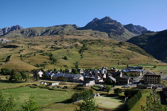
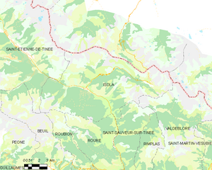
Saint-Étienne-de-Tinée (Saint-Étienne-de-Tinée)
- commune in Alpes-Maritimes, France
 Hiking in Saint-Étienne-de-Tinée
Saint-Étienne-de-Tinée is a charming village located in the Alpes-Maritimes region of southeastern France, nestled in the Tinée Valley. It serves as a great base for hikers looking to explore the stunning natural landscapes of the surrounding area, including the Mercantour National Park, which is renowned for its dramatic scenery and diverse wildlife.
Hiking Trails and Areas
-
Mercantour National Park: Just a short distance from Saint-Étienne-de-Tinée, this national park offers an extensive network of hiking trails ranging from easy walks to challenging treks. The park is famous for its rugged mountains, alpine lakes, and rich biodiversity. Popular trails include the path to Lac d'Allos and the route to the iconic Vésubie valley.
-
GR5 Trail: This long-distance hiking trail runs through the region and provides access to breathtaking views and panoramic vistas. Parts of it can be tackled in day-hikes or multi-day trips.
-
Local Trails: There are several well-marked local trails starting from the village itself, which offer easier hikes suitable for families or those looking for a relaxed day in nature. These trails often lead to beautiful lookout points or through picturesque mountain landscapes.
Best Times to Hike
- Summer (June to September): This is the most popular season for hiking, as the trails are generally clear of snow, and the weather is typically warm and pleasant.
- Autumn (October): The fall months can offer stunning foliage, and the cooler temperatures are great for hiking, but be cautious about possible early snow and trail conditions.
- Winter (December to March): While hiking may be limited due to snow, this is a good time for snowshoeing and ski touring in the area.
Tips for Hiking in Saint-Étienne-de-Tinée
- Prepare for changes in weather: Mountain weather can be unpredictable, so it's essential to carry layers, extra gear, and sufficient water.
- Check trail conditions: Before heading out, check for any trail closures or specific conditions related to the season.
- Respect wildlife: The area hosts various wildlife species. Keep a respectful distance and leave no trace.
Facilities and Amenities
Saint-Étienne-de-Tinée has a range of accommodations, from hotels to camping options, as well as shops and restaurants to stock up on supplies or enjoy local cuisine after a long day of hiking.
In summary, Saint-Étienne-de-Tinée is a wonderful destination for hiking enthusiasts, offering access to some of the most beautiful natural settings in the Alps. Whether you’re a novice or an experienced hiker, you'll find trails that cater to your skill level and interests.
- Country:

- Postal Code: 06660
- Coordinates: 44° 15' 25" N, 6° 55' 29" E


- GPS tracks (wikiloc): [Link]
- AboveSeaLevel: 1139 м m
- Area: 173.81 sq km
- Population: 1468
- Wikipedia en: wiki(en)
- Wikipedia: wiki(fr)
- Wikidata storage: Wikidata: Q993780
- Wikipedia Commons Category: [Link]
- GeoNames ID: Alt: [2980247]
- GeoNames ID: Alt: [2980247]
- SIREN number: [210601209]
- SIREN number: [210601209]
- BnF ID: [12350524c]
- BnF ID: [12350524c]
- VIAF ID: Alt: [238167555]
- VIAF ID: Alt: [238167555]
- Library of Congress authority ID: Alt: [no2018094037]
- Library of Congress authority ID: Alt: [no2018094037]
- PACTOLS thesaurus ID: [pcrt0uB7RsXSVa]
- PACTOLS thesaurus ID: [pcrt0uB7RsXSVa]
- INSEE municipality code: 06120
- INSEE municipality code: 06120
Shares border with regions:
Larche
- former commune in Alpes-de-Haute-Provence, France
Hiking in Larche
L'Arche, located in the Alpes-de-Haute-Provence region of France, is a fantastic destination for hiking enthusiasts. The area is characterized by its stunning landscapes, varied terrain, and the rich natural beauty of the French Alps. Here are some key highlights about hiking in Larche:...
- Country:
- Postal Code: 04540
- Coordinates: 44° 27' 5" N, 6° 50' 48" E
- GPS tracks (wikiloc): [Link]
- Area: 68.86 sq km
- Population: 55

Argentera
- Italian comune
Hiking in Argentera
Argentera is a beautiful area located in the Piedmont region of Italy, within the Maritime Alps. It is well-known for its stunning landscapes, diverse flora and fauna, and a wide range of hiking trails suitable for all skill levels. Here are some details about hiking in Argentera:...
- Country:

- Postal Code: 12010
- Local Dialing Code: 0171
- Licence Plate Code: CN
- Coordinates: 44° 23' 47" N, 6° 56' 16" E
- GPS tracks (wikiloc): [Link]
- AboveSeaLevel: 1684 м m
- Area: 76.26 sq km
- Population: 78
- Web site: [Link]

Pietraporzio
- Italian comune
Hiking in Pietraporzio
Pietraporzio is a picturesque village located in the Piedmont region of Italy, nestled in the Susa Valley and surrounded by the majestic Alps. The area offers a variety of hiking trails suitable for different skill levels, making it a great destination for both novice and experienced hikers....
- Country:
- Postal Code: 12010
- Local Dialing Code: 0171
- Licence Plate Code: CN
- Coordinates: 44° 21' 0" N, 7° 2' 0" E
- GPS tracks (wikiloc): [Link]
- AboveSeaLevel: 1246 м m
- Area: 55.19 sq km
- Population: 79
- Web site: [Link]

Vinadio
- Italian comune
Hiking in Vinadio
Vinadio, a charming village nestled in the Piedmont region of Italy, is an excellent destination for hiking enthusiasts. Situated in the upper part of the Stura Valley, it's surrounded by the stunning Maritime Alps, making it a perfect spot for both casual walkers and experienced hikers....
- Country:
- Postal Code: 12010
- Local Dialing Code: 0171
- Licence Plate Code: CN
- Coordinates: 44° 18' 0" N, 7° 10' 0" E
- GPS tracks (wikiloc): [Link]
- AboveSeaLevel: 904 м m
- Area: 183.17 sq km
- Population: 629
- Web site: [Link]

Jausiers
- commune in Alpes-de-Haute-Provence, France
Hiking in Jausiers
Jausiers is a charming village located in the Alpes-de-Haute-Provence region of France. It's nestled in the heart of the French Alps and offers attractive hiking opportunities for outdoor enthusiasts. Here are some highlights about hiking in and around Jausiers:...
- Country:
- Postal Code: 04850
- Coordinates: 44° 25' 4" N, 6° 43' 50" E
- GPS tracks (wikiloc): [Link]
- Area: 107.73 sq km
- Population: 1133
- Web site: [Link]


Beuil
- commune in Alpes-Maritimes, France
Hiking in Beuil
Beuil is a picturesque village located in the Alpes-Maritimes region of southeastern France, known for its stunning alpine scenery and outdoor recreational opportunities. It serves as an excellent base for hiking enthusiasts, offering a variety of trails that cater to different skill levels....
- Country:
- Postal Code: 06470
- Coordinates: 44° 5' 42" N, 6° 59' 15" E
- GPS tracks (wikiloc): [Link]
- Area: 75.65 sq km
- Population: 513
- Web site: [Link]

Isola
- commune in Alpes-Maritimes, France
Hiking in Isola
Isola is a charming village located in the Alpes-Maritimes region of France, renowned for its stunning natural landscapes and outdoor activities, especially hiking. Situated in the heart of the Southern Alps, Isola offers a variety of trails that cater to different skill levels, from leisurely walks to more challenging hikes....
- Country:
- Postal Code: 06420
- Coordinates: 44° 11' 9" N, 7° 3' 8" E
- GPS tracks (wikiloc): [Link]
- Area: 97.98 sq km
- Population: 693


Entraunes
- commune in Alpes-Maritimes, France
Hiking in Entraunes
Entraunes, located in the Alpes-Maritimes region of France, is a beautiful destination for hiking enthusiasts. Nestled in the Mercantour National Park, it offers stunning natural landscapes, diverse flora and fauna, and a variety of trails that cater to different skill levels....
- Country:
- Postal Code: 06470
- Coordinates: 44° 11' 17" N, 6° 44' 54" E
- GPS tracks (wikiloc): [Link]
- Area: 81.45 sq km
- Population: 118

Péone
- commune in Alpes-Maritimes, France
Hiking in Péone
Péone is a charming village located in the Alpes-Maritimes region of France, nestled in the Southern French Alps. It offers various hiking opportunities, ideal for both beginners and experienced hikers. Here are some key points about hiking in the area:...
- Country:
- Postal Code: 06470
- Coordinates: 44° 7' 3" N, 6° 54' 30" E
- GPS tracks (wikiloc): [Link]
- Area: 48.59 sq km
- Population: 866
- Web site: [Link]


Châteauneuf-d'Entraunes
- commune in Alpes-Maritimes, France
Hiking in Châteauneuf-d'Entraunes
Châteauneuf-d'Entraunes is a picturesque village located in the Alpes-Maritimes department of France. Nestled in the Mercantour National Park, it offers a variety of hiking opportunities suitable for different levels of experience. Here are some highlights and tips for hiking in this beautiful area:...
- Country:
- Postal Code: 06470
- Coordinates: 44° 7' 42" N, 6° 49' 56" E
- GPS tracks (wikiloc): [Link]
- Area: 29.91 sq km
- Population: 47
- Web site: [Link]

Saint-Dalmas-le-Selvage
- commune in Alpes-Maritimes, France
Hiking in Saint-Dalmas-le-Selvage
Saint-Dalmas-le-Selvage is a beautiful village located in the Alpes-Maritimes department in southeastern France, known for its stunning mountain scenery and access to numerous hiking trails. Here are some highlights and tips for hiking in the area:...
- Country:
- Postal Code: 06660
- Coordinates: 44° 17' 5" N, 6° 51' 58" E
- GPS tracks (wikiloc): [Link]
- Area: 81.03 sq km
- Population: 122


Guillaumes
- small village in the south-east of France department of Alpes-Maritimes
Hiking in Guillaumes
Guillaumes is a charming village located in the Alpes-Maritimes department in southeastern France. It’s nestled in the Mercantour National Park, making it a fantastic base for hikers and nature enthusiasts. Here are some highlights and tips for hiking in the Guillaumes area:...
- Country:
- Postal Code: 06470
- Coordinates: 44° 5' 26" N, 6° 51' 13" E
- GPS tracks (wikiloc): [Link]
- Area: 87.02 sq km
- Population: 640