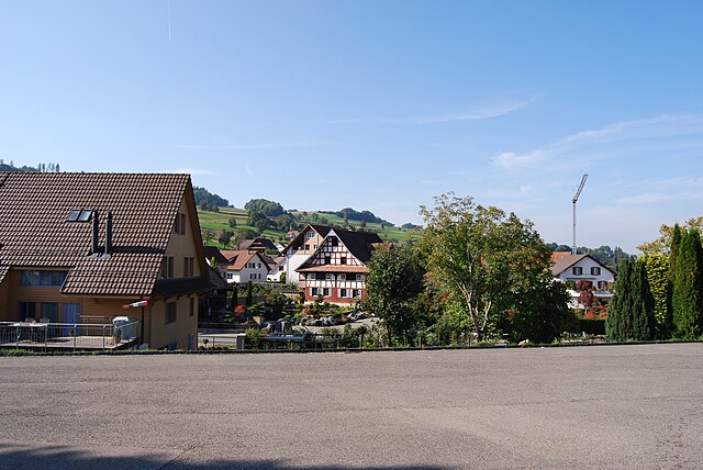
Aristau (Aristau)

- municipality in Switzerland
 Hiking in Aristau
Aristau is a beautiful and less-traveled destination perfect for hiking enthusiasts. Located in the Swiss region, it offers scenic views, lush landscapes, and a variety of trails suitable for different skill levels. Here’s an overview of what you can expect when hiking in Aristau:
Trail Options
- Beginner Trails: These are usually flatter and well-marked pathways, ideal for families or those new to hiking. They often take you through beautiful meadows and along streams.
- Intermediate Trails: These trails may have some elevation changes and are suitable for hikers with a moderate level of fitness. They offer more challenging terrain and captivating views of the surrounding mountains.
- Advanced Trails: For seasoned hikers, there are more demanding routes that involve steep ascents and rugged paths. These trails can lead you to breathtaking panoramas and remote areas.
Scenic Highlights
- Mountain Views: The region offers stunning vistas of the Swiss Alps, making it a photographer’s paradise.
- Lush Forests: Many trails wind through dense forests, giving you a chance to appreciate local flora and fauna.
- Alpine Lakes: Depending on the specific trail, you might encounter picturesque alpine lakes, perfect for a refreshing break.
Best Time to Hike
- Spring and Autumn: These seasons provide mild temperatures and vibrant landscapes. Spring showcases blooming wildflowers, while autumn offers colorful foliage.
- Summer: While popular, summer can be warm and sometimes crowded. Early morning hikes can help you avoid the heat and crowds.
Preparation
- Gear: Good hiking boots, weather-appropriate clothing, plenty of water, and snacks are essential. A map or GPS device is also recommended.
- Safety: Check weather conditions prior to your hike, and be aware of your physical limits. Always inform someone about your hiking plan.
Local Regulations
Ensure to respect local wildlife and stay on designated trails to preserve the natural beauty of the area.
Whether you are looking for a leisurely walk or an adventurous trek, Aristau has something to offer every hiker! Enjoy the experience of immersing yourself in nature.
- Country:

- Postal Code: 5628
- Local Dialing Code: 056
- Licence Plate Code: AG
- Coordinates: 47° 17' 29" N, 8° 21' 50" E


- GPS tracks (wikiloc): [Link]
- AboveSeaLevel: 387 м m
- Area: 8.64 sq km
- Population: 1436
- Web site: http://www.aristau.ch
- Wikipedia en: wiki(en)
- Wikipedia: wiki(de)
- Wikidata storage: Wikidata: Q64752
- Wikipedia Commons Category: [Link]
- Freebase ID: [/m/0flrr7]
- GeoNames ID: Alt: [7285095]
- VIAF ID: Alt: [239711084]
- OSM relation ID: [1684255]
- archINFORM location ID: [15567]
- HDS ID: [1777]
- Swiss municipality code: [4222]
Shares border with regions:


Merenschwand
- municipality in Switzerland
Hiking in Merenschwand
Merenschwand, a picturesque municipality located in the Canton of Aargau in Switzerland, offers a variety of hiking opportunities that cater to different skill levels. Nestled in a beautiful landscape characterized by rolling hills, forests, and stunning views of the surrounding countryside, it's an excellent destination for both casual walkers and more experienced hikers....
- Country:
- Postal Code: 5634
- Local Dialing Code: 056
- Licence Plate Code: AG
- Coordinates: 47° 15' 44" N, 8° 22' 39" E
- GPS tracks (wikiloc): [Link]
- AboveSeaLevel: 381 м m
- Area: 13.51 sq km
- Population: 3393
- Web site: [Link]


Jonen
- municipality in Switzerland
Hiking in Jonen
Jonen, known for its picturesque landscapes and hiking opportunities, is a great destination for outdoor enthusiasts in Switzerland. Located in the canton of Aargau, it offers scenic trails that cater to various skill levels, making it suitable for families, casual walkers, and seasoned hikers alike....
- Country:
- Postal Code: 8916
- Local Dialing Code: 056
- Licence Plate Code: AG
- Coordinates: 47° 17' 54" N, 8° 23' 50" E
- GPS tracks (wikiloc): [Link]
- AboveSeaLevel: 446 м m
- Area: 5.70 sq km
- Population: 2061
- Web site: [Link]

Boswil
- municipality in Switzerland
Hiking in Boswil
Boswil, a charming village located in the Canton of Aargau, Switzerland, offers a variety of hiking opportunities suited for different skill levels amidst beautiful landscapes. Here are some key details about hiking in Boswil:...
- Country:
- Postal Code: 5623
- Local Dialing Code: 056
- Licence Plate Code: AG
- Coordinates: 47° 18' 4" N, 8° 18' 50" E
- GPS tracks (wikiloc): [Link]
- AboveSeaLevel: 475 м m
- Area: 11.78 sq km
- Population: 2783
- Web site: [Link]


Besenbüren
- municipality in Switzerland
Hiking in Besenbüren
Besenbüren, located in Switzerland, is a charming village in the canton of Aargau. It offers a serene environment for hiking enthusiasts, primarily known for its picturesque landscapes, rolling hills, and inviting trails. Here are some key points about hiking in Besenbüren:...
- Country:
- Postal Code: 5627
- Local Dialing Code: 056
- Licence Plate Code: AG
- Coordinates: 47° 18' 54" N, 8° 20' 45" E
- GPS tracks (wikiloc): [Link]
- AboveSeaLevel: 450 м m
- Area: 2.38 sq km
- Population: 624
- Web site: [Link]

Ottenbach
- municipality in Switzerland
Hiking in Ottenbach
Ottenbach, a picturesque village located in the Canton of Aargau in Switzerland, offers a great setting for hiking enthusiasts. The surrounding landscapes provide a delightful mix of rolling hills, forested areas, and charming valleys, making it an excellent spot for both beginners and experienced hikers....
- Country:
- Postal Code: 8913
- Local Dialing Code: 044
- Licence Plate Code: ZH
- Coordinates: 47° 16' 53" N, 8° 24' 14" E
- GPS tracks (wikiloc): [Link]
- AboveSeaLevel: 409 м m
- Area: 4.98 sq km
- Population: 2556
- Web site: [Link]

Muri
- municipality in the canton Aargau, Switzerland
Hiking in Muri
Muri, located in the Aargau region of Switzerland, is surrounded by beautiful landscapes that offer great opportunities for hiking enthusiasts. The area features a combination of rolling hills, forests, and scenic views that are characteristic of the Swiss countryside....
- Country:
- Postal Code: 5630
- Local Dialing Code: 056
- Licence Plate Code: AG
- Coordinates: 47° 16' 29" N, 8° 20' 30" E
- GPS tracks (wikiloc): [Link]
- AboveSeaLevel: 478 м m
- Area: 12.34 sq km
- Population: 7769
- Web site: [Link]