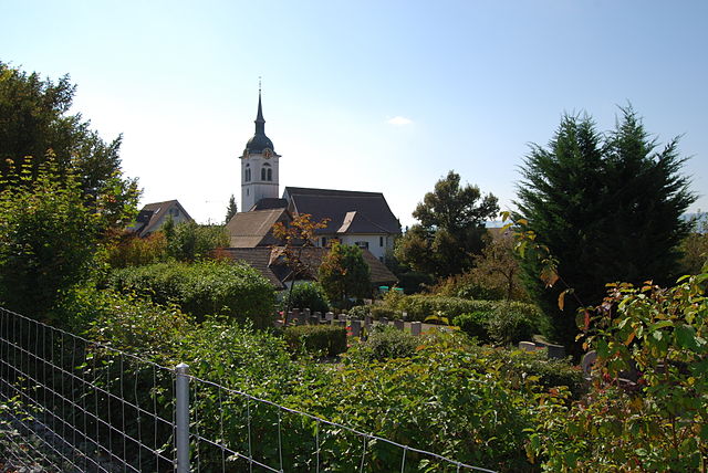
Arni (Arni AG)
- municipality in the canton Aargau, Switzerland
Arni, located in the canton of Aargau, Switzerland, is known for its beautiful landscapes and offers a variety of hiking opportunities suitable for different skill levels. Here are some aspects to consider for hiking in and around Arni:
Scenic Trails
-
Regional Trails: The area features various marked regional hiking trails that lead through lush forests, rolling hills, and picturesque farmland. The landscapes are characterized by stunning views of the surrounding hills and the Aargau countryside.
-
The Reuss River: Many hiking routes near Arni follow the Reuss River, allowing hikers to enjoy serene riverside views.
-
Views of the Alps: On clear days, you can catch glimpses of the distant Alps, adding to the enchanting beauty of the hikes in the area.
Difficulty Levels
- Easy Hikes: Beginners can find plenty of easier trails ideal for family outings or leisurely strolls, often suitable for children and casual walkers.
- Intermediate and Advanced Options: There are also more challenging routes for experienced hikers looking for a workout or a more immersive experience in nature.
Nature and Wildlife
Hiking in Arni provides a great opportunity to observe local flora and fauna. Keep an eye out for various bird species, deer, and other wildlife. The area’s natural environment is lush and diverse, offering a vibrant hiking experience year-round.
Best Times to Hike
- Spring and Autumn: These seasons often provide the most pleasant weather conditions for hiking, with blooming wildflowers in spring and beautiful fall foliage.
- Summer: While summer can be warmer, it also offers longer daylight hours for extended hikes. Be sure to bring plenty of water and sun protection.
- Winter: Some trails may be suitable for winter hiking, but check conditions ahead of time, as snow can affect accessibility.
Tips
- Trail Maps: Consider picking up a trail map from local tourist information centers or looking for resources online to help you navigate.
- Gear: Sturdy hiking boots, weather-appropriate clothing, and sufficient hydration are essential, regardless of the length of the hike.
- Respect Nature: Always adhere to local guidelines regarding trail use, and remember to carry out what you bring in.
Local Amenities
After a day of hiking, you can enjoy local Swiss cuisine at nearby restaurants or cafes, giving you a chance to relax and refuel.
Whether you're a seasoned hiker or just looking for a pleasant day outdoors, Arni offers a lovely environment to explore. Enjoy your hike in this beautiful region!
- Country:

- Postal Code: 8905
- Local Dialing Code: 056
- Licence Plate Code: AG
- Coordinates: 47° 19' 9" N, 8° 25' 20" E


- GPS tracks (wikiloc): [Link]
- AboveSeaLevel: 568 м m
- Area: 3.37 sq km
- Population: 1867
- Web site: http://www.arni-ag.ch
- Wikipedia en: wiki(en)
- Wikipedia: wiki(de)
- Wikidata storage: Wikidata: Q64324
- Wikipedia Commons Category: [Link]
- Freebase ID: [/m/05p3zx]
- GeoNames ID: Alt: [7285099]
- VIAF ID: Alt: [236141312]
- OSM relation ID: [1684256]
- HDS ID: [1660]
- Swiss municipality code: [4061]
Shares border with regions:


Oberlunkhofen
- municipality in Switzerland
Oberlunkhofen is a small village located in Switzerland, surrounded by beautiful natural landscapes that make it a great spot for hiking enthusiasts. The area features a mix of rolling hills, forests, and picturesque views of the Swiss countryside, making it ideal for various levels of hiking experiences....
- Country:

- Postal Code: 8917
- Local Dialing Code: 056
- Licence Plate Code: AG
- Coordinates: 47° 18' 45" N, 8° 23' 52" E


- GPS tracks (wikiloc): [Link]
- AboveSeaLevel: 488 м m
- Area: 3.25 sq km
- Population: 2012
- Web site: [Link]


Jonen
- municipality in Switzerland
Jonen, known for its picturesque landscapes and hiking opportunities, is a great destination for outdoor enthusiasts in Switzerland. Located in the canton of Aargau, it offers scenic trails that cater to various skill levels, making it suitable for families, casual walkers, and seasoned hikers alike....
- Country:

- Postal Code: 8916
- Local Dialing Code: 056
- Licence Plate Code: AG
- Coordinates: 47° 17' 54" N, 8° 23' 50" E


- GPS tracks (wikiloc): [Link]
- AboveSeaLevel: 446 м m
- Area: 5.70 sq km
- Population: 2061
- Web site: [Link]


Hedingen
- municipality in Switzerland
Hedingen is a charming municipality located in the canton of Zurich, Switzerland, known for its picturesque landscapes and varied hiking trails. Here are some aspects to consider if you're planning to hike in Hedingen:...
- Country:

- Postal Code: 8908
- Local Dialing Code: 044
- Licence Plate Code: ZH
- Coordinates: 47° 17' 55" N, 8° 26' 58" E


- GPS tracks (wikiloc): [Link]
- AboveSeaLevel: 501 м m
- Area: 6.59 sq km
- Population: 3694
- Web site: [Link]


Unterlunkhofen
- municipality in Switzerland
Unterlunkhofen is a quaint village located in Switzerland, nestled in the scenic region of Canton Aargau. The area around Unterlunkhofen offers some beautiful hiking opportunities, where you can enjoy the lush landscapes and picturesque views of the Swiss countryside....
- Country:

- Postal Code: 8918
- Local Dialing Code: 056
- Licence Plate Code: AG
- Coordinates: 47° 19' 29" N, 8° 22' 59" E


- GPS tracks (wikiloc): [Link]
- AboveSeaLevel: 454 м m
- Area: 4.49 sq km
- Population: 1383
- Web site: [Link]


Oberwil-Lieli
- municipality in the district of Bremgarten in the canton of Aargau in Switzerland
Oberwil-Lieli is a charming municipality in the canton of Aargau, Switzerland, known for its beautiful landscapes and outdoor recreational opportunities, including hiking. Here are some aspects to consider when hiking in and around Oberwil-Lieli:...
- Country:

- Postal Code: 8966
- Local Dialing Code: 056
- Licence Plate Code: AG
- Coordinates: 47° 20' 0" N, 8° 23' 0" E


- GPS tracks (wikiloc): [Link]
- AboveSeaLevel: 565 м m
- Area: 5.35 sq km
- Population: 2363
- Web site: [Link]

