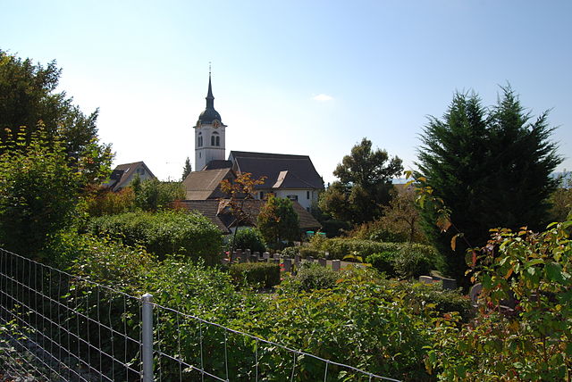
Unterlunkhofen (Unterlunkhofen)
- municipality in Switzerland
Unterlunkhofen is a quaint village located in Switzerland, nestled in the scenic region of Canton Aargau. The area around Unterlunkhofen offers some beautiful hiking opportunities, where you can enjoy the lush landscapes and picturesque views of the Swiss countryside.
Hiking Trails
-
Local Trails: The village itself is surrounded by several local hiking trails that vary in difficulty. Many of these trails take you through stunning meadows, forests, and fields, making it a great spot for nature lovers.
-
Promenade Trails: There are also well-marked promenade paths that are suitable for families and casual walkers, providing a gentle stroll with stunning views of the surrounding hills and valleys.
-
Connection to Larger Trail Networks: Unterlunkhofen is a starting point for longer hikes that connect to more extensive networks, allowing you to explore further into the region, including nearby towns and natural reserves.
Recommended Hikes
- Hiking to Hertenstein: A popular trail that provides beautiful panoramas and a mix of terrain, from forest paths to open fields.
- Woodland Trails: Explore the nearby forests, which are ideal for those seeking solitude and the beauty of nature. Watch for local wildlife along the way.
Hiking Tips
- Weather Check: Always check the weather conditions before heading out, as Swiss weather can change quickly.
- Proper Footwear: Invest in good hiking shoes or boots, as trails can be uneven or muddy, especially after rain.
- Hydration and Snacks: Carry enough water and snacks, particularly on longer hikes, to keep your energy up.
- Map and Compass: Familiarize yourself with the area’s trails and bring a map or download a hiking app, as trail markings can sometimes be sparse.
Accessibility
Unterlunkhofen is accessible by public transport, making it easy to reach from larger Swiss cities. Consider taking the train to the nearest station and then hiking into the village.
In summary, hiking in Unterlunkhofen provides an excellent opportunity to immerse yourself in the tranquil beauty of the Swiss countryside, with a variety of trails to suit all skill levels. Enjoy your hike!
- Country:

- Postal Code: 8918
- Local Dialing Code: 056
- Licence Plate Code: AG
- Coordinates: 47° 19' 29" N, 8° 22' 59" E


- GPS tracks (wikiloc): [Link]
- AboveSeaLevel: 454 м m
- Area: 4.49 sq km
- Population: 1383
- Web site: http://www.unterlunkhofen.ch
- Wikipedia en: wiki(en)
- Wikipedia: wiki(de)
- Wikidata storage: Wikidata: Q65150
- Wikipedia Commons Category: [Link]
- Freebase ID: [/m/0fr0tp]
- GeoNames ID: Alt: [7287382]
- VIAF ID: Alt: [233698029]
- OSM relation ID: [1684448]
- HDS ID: [1678]
- Swiss municipality code: [4079]
Shares border with regions:


Oberlunkhofen
- municipality in Switzerland
Oberlunkhofen is a small village located in Switzerland, surrounded by beautiful natural landscapes that make it a great spot for hiking enthusiasts. The area features a mix of rolling hills, forests, and picturesque views of the Swiss countryside, making it ideal for various levels of hiking experiences....
- Country:

- Postal Code: 8917
- Local Dialing Code: 056
- Licence Plate Code: AG
- Coordinates: 47° 18' 45" N, 8° 23' 52" E


- GPS tracks (wikiloc): [Link]
- AboveSeaLevel: 488 м m
- Area: 3.25 sq km
- Population: 2012
- Web site: [Link]


Arni
- municipality in the canton Aargau, Switzerland
Arni, located in the canton of Aargau, Switzerland, is known for its beautiful landscapes and offers a variety of hiking opportunities suitable for different skill levels. Here are some aspects to consider for hiking in and around Arni:...
- Country:

- Postal Code: 8905
- Local Dialing Code: 056
- Licence Plate Code: AG
- Coordinates: 47° 19' 9" N, 8° 25' 20" E


- GPS tracks (wikiloc): [Link]
- AboveSeaLevel: 568 м m
- Area: 3.37 sq km
- Population: 1867
- Web site: [Link]


Oberwil-Lieli
- municipality in the district of Bremgarten in the canton of Aargau in Switzerland
Oberwil-Lieli is a charming municipality in the canton of Aargau, Switzerland, known for its beautiful landscapes and outdoor recreational opportunities, including hiking. Here are some aspects to consider when hiking in and around Oberwil-Lieli:...
- Country:

- Postal Code: 8966
- Local Dialing Code: 056
- Licence Plate Code: AG
- Coordinates: 47° 20' 0" N, 8° 23' 0" E


- GPS tracks (wikiloc): [Link]
- AboveSeaLevel: 565 м m
- Area: 5.35 sq km
- Population: 2363
- Web site: [Link]

