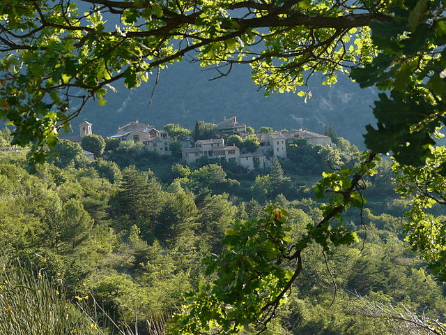
Arpavon (Arpavon)

- commune in Drôme, France
 Hiking in Arpavon
Arpavon, located in the scenic region of the Drôme Provençale in southeastern France, offers a delightful experience for hikers. The area is characterized by its diverse landscapes, including hills, vineyards, and picturesque villages, making it an ideal destination for nature lovers.
Hiking Highlights in Arpavon:
-
Scenic Trails: The trails range from easy walks suitable for families to more challenging hikes for seasoned adventurers. Many paths offer stunning views of the surrounding countryside, especially during sunrise or sunset.
-
Natural Beauty: Hikers can enjoy the beauty of the local flora and fauna, as well as the vibrant colors of the vineyards. The landscapes are particularly picturesque in the spring and fall.
-
Cultural Exploration: Along the trails, you might encounter charming villages and historical sites that reflect the rich cultural heritage of the region. Stopping by local markets or enjoying regional cuisine can enhance your hiking experience.
-
Wildlife Observation: The area is home to diverse wildlife, so keep your eyes peeled for various bird species, small mammals, and unique plant life.
-
Weather Considerations: The climate in Arpavon is typically Mediterranean, so summers can be hot while winters are mild. Spring and fall are particularly pleasant for hiking, with moderate temperatures and blooming landscapes.
Tips for Hiking in Arpavon:
- Proper Gear: Wear comfortable hiking shoes and dress in layers to accommodate changing weather conditions.
- Hydration: Always carry enough water, especially during warmer months.
- Trail Maps: Consider obtaining a local map or using a reliable hiking app to navigate the trails.
- Respect Nature: Stick to marked paths and follow local guidelines to preserve the area’s natural beauty.
Conclusion
Hiking in Arpavon is a rewarding experience with its blend of natural beauty, cultural richness, and diverse trails. Whether you are a beginner or an experienced hiker, Arpavon promises a memorable adventure in the heart of Provence. Always check local resources for trail conditions and any necessary permits or guidelines before heading out. Happy hiking!
- Country:

- Postal Code: 26110
- Coordinates: 44° 22' 12" N, 5° 16' 4" E


- GPS tracks (wikiloc): [Link]
- Area: 13.45 sq km
- Population: 81
- Wikipedia en: wiki(en)
- Wikipedia: wiki(fr)
- Wikidata storage: Wikidata: Q384704
- Wikipedia Commons Category: [Link]
- Freebase ID: [/m/03mgk42]
- GeoNames ID: Alt: [6447865]
- SIREN number: [212600134]
- BnF ID: [15252874g]
- PACTOLS thesaurus ID: [pcrto8njsGkHKI]
- INSEE municipality code: 26013
Shares border with regions:

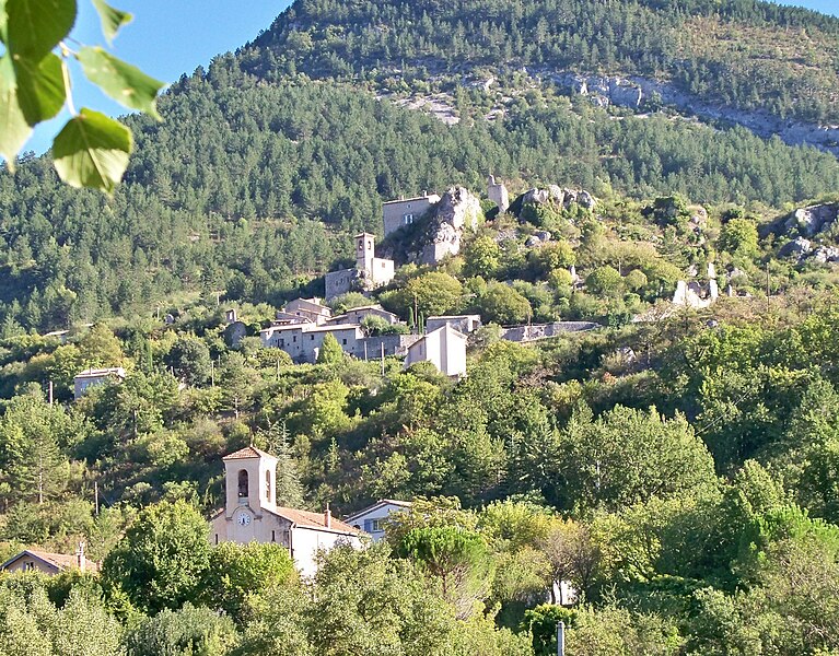
Montaulieu
- commune in Drôme, France
Hiking in Montaulieu
Montaulieu, located in the Vaucluse region of France, offers a variety of hiking opportunities that cater to different skill levels. The area is known for its beautiful landscapes, including hills, forests, and panoramic views of the surrounding countryside. Here are some key points about hiking in Montaulieu:...
- Country:
- Postal Code: 26110
- Coordinates: 44° 21' 28" N, 5° 13' 26" E
- GPS tracks (wikiloc): [Link]
- Area: 13.05 sq km
- Population: 82
- Web site: [Link]

Sahune
- commune in Drôme, France
Hiking in Sahune
Sahune is a charming village located in the Drôme department of the Auvergne-Rhône-Alpes region in southeastern France. It's known for its beautiful landscapes, rolling hills, and proximity to the Vercors Regional Natural Park, making it a great base for hiking enthusiasts....
- Country:
- Postal Code: 26510
- Coordinates: 44° 24' 53" N, 5° 16' 2" E
- GPS tracks (wikiloc): [Link]
- Area: 16.55 sq km
- Population: 312


Sainte-Jalle
- commune in Drôme, France
Hiking in Sainte-Jalle
Sainte-Jalle is a picturesque village located in the Drôme department in the Auvergne-Rhône-Alpes region of France. The area surrounding Sainte-Jalle is known for its stunning landscapes, with rolling hills, rocky outcrops, and expansive vineyards, making it a great destination for hiking enthusiasts....
- Country:
- Postal Code: 26110
- Coordinates: 44° 20' 42" N, 5° 17' 2" E
- GPS tracks (wikiloc): [Link]
- Area: 18.16 sq km
- Population: 301


Rochebrune
- commune in Drôme, France
Hiking in Rochebrune
Rochebrune is a picturesque region located in the Drôme department of southeastern France, known for its stunning natural landscapes and diverse hiking opportunities. If you're planning to hike in Rochebrune, here are some key points to consider:...
- Country:
- Postal Code: 26110
- Coordinates: 44° 20' 13" N, 5° 14' 44" E
- GPS tracks (wikiloc): [Link]
- Area: 16.15 sq km
- Population: 61


Curnier
- commune in Drôme, France
Hiking in Curnier
Curnier is a picturesque village located in the Jura Mountains of Switzerland. This region is known for its stunning landscapes, rich biodiversity, and well-marked hiking trails that cater to various skill levels. Here’s what you can expect when hiking in and around Curnier:...
- Country:
- Postal Code: 26110
- Coordinates: 44° 23' 6" N, 5° 14' 4" E
- GPS tracks (wikiloc): [Link]
- Area: 8 sq km
- Population: 177


Le Poët-Sigillat
- commune in Drôme, France
Hiking in Le Poët-Sigillat
Le Poët-Sigillat is a small village located in the Drôme department of the Auvergne-Rhône-Alpes region in southeastern France. The area is known for its picturesque landscapes and tranquil environment, making it a great destination for hiking enthusiasts....
- Country:
- Postal Code: 26110
- Coordinates: 44° 22' 8" N, 5° 19' 1" E
- GPS tracks (wikiloc): [Link]
- Area: 15.36 sq km
- Population: 119


Montréal-les-Sources
- commune in Drôme, France
Hiking in Montréal-les-Sources
Montréal-les-Sources, located in the beautiful region of Quebec, offers stunning natural landscapes and a variety of hiking trails for outdoor enthusiasts. Here are some key points to consider when hiking in this area:...
- Country:
- Postal Code: 26510
- Coordinates: 44° 24' 5" N, 5° 18' 0" E
- GPS tracks (wikiloc): [Link]
- Area: 10.26 sq km
- Population: 26