arrondissement of Briançon (arrondissement de Briançon)

- arrondissement of France
 Hiking in arrondissement of Briançon
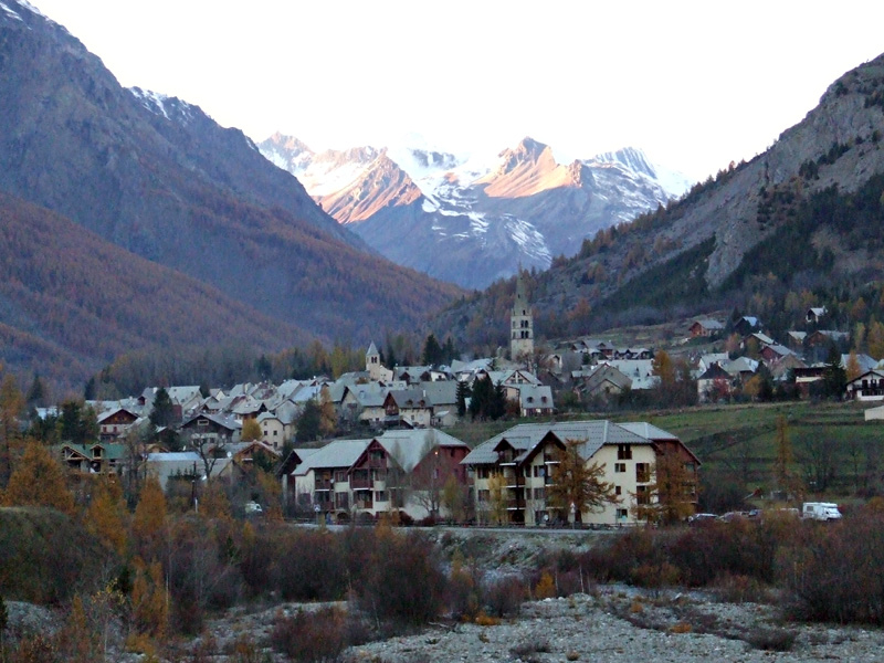
The Arrondissement of Briançon, located in the Hautes-Alpes department of the Provence-Alpes-Côte d'Azur region in France, is renowned for its stunning Alpine scenery and offers a plethora of hiking opportunities. Here are key highlights and information about hiking in this beautiful area:
Landscape and Environment
- Mountain Range: The area is part of the Southern Alps, featuring impressive peaks, valleys, and alpine meadows.
- Natural Parks: The Parc National des Écrins is nearby, providing a vast range of terrains, from rugged mountains to serene lakes.
- Flora and Fauna: Hikers can encounter diverse wildlife, including chamois, ibex, and various bird species, along with unique alpine flora.
Popular Hiking Trails
-
Col d’Izoard: A famous mountain pass with scenic trails that offer stunning views of the surrounding peaks. The area is also known for its dramatic landscapes and historical significance in cycling.
-
Lac des Cerces: This trail leads to a beautiful mountain lake, which is accessible in the summer months. The hike offers a moderate challenge and rewards hikers with breathtaking vistas.
-
Sentier des Cabanes: This is a relatively easy trail that takes you through picturesque villages and allows you to discover the traditional Alpine architecture and history of the region.
-
Tour de la Meije: For more experienced hikers, this trek around the Meije massif provides challenging routes and incredible views, especially for those seeking multi-day treks.
Hiking Tips
- Season: The best time to hike in the Arrondissement of Briançon is from late spring to early autumn (May to September) when the weather is mild and the trails are clear of snow.
- Preparation: Always check the weather conditions before your hike, as mountain weather can change rapidly. Carry the appropriate gear, including sturdy shoes, layers of clothing, and adequate water and snacks.
- Guided Tours: For those unfamiliar with the area or seeking a more in-depth experience, consider joining a guided hiking tour. Local guides can enhance your understanding of the region's environment and history.
Safety
- Navigation: Some trails may not be well-marked; ensure you have a map, compass, or GPS device. Mobile reception can be limited in remote areas.
- Altitude: Be mindful of altitude sickness, especially on higher trails. Ascend gradually and stay hydrated.
Conclusion
The Arrondissement of Briançon is a hiker’s paradise, offering something for everyone from leisurely walks to challenging treks. Whether you’re a seasoned hiker or a beginner, the stunning landscapes and fresh Alpine air create an unforgettable experience. Always respect the natural environment and local regulations while exploring this beautiful area. Happy hiking!
- Country:

- Capital: Briançon
- Coordinates: 44° 45' 0" N, 6° 40' 0" E


- GPS tracks (wikiloc): [Link]
- Area: 2138 sq km
- Population: 35673
- Wikipedia en: wiki(en)
- Wikipedia: wiki(fr)
- Wikidata storage: Wikidata: Q700744
- Freebase ID: [/m/095kmm]
- GeoNames ID: Alt: [3030140]
- INSEE arrondissement code: [051]
Includes regions:
canton of Le Monêtier-les-Bains
- canton of France (until March 2015)
Hiking in canton of Le Monêtier-les-Bains
Canton of Le Monêtier-les-Bains, located in the French Alps, offers a stunning backdrop for hiking enthusiasts. Nestled in the Écrins National Park, this area features a diverse range of trails suited for various skill levels, from leisurely walks to more challenging hikes....
- Country:
- Capital: Le Monêtier-les-Bains
- Coordinates: 44° 58' 37" N, 6° 30' 34" E
- GPS tracks (wikiloc): [Link]

canton of Briançon-Nord
- canton of France (until March 2015)
Hiking in canton of Briançon-Nord
Canton de Briançon-Nord, located in the French Alps, offers a stunning setting for hiking enthusiasts. This region is characterized by its diverse landscapes, including alpine meadows, rugged mountains, and charming villages. Here are some highlights and tips for hiking in the area:...
canton of Briançon-Sud
- canton of France
Hiking in canton of Briançon-Sud
Hiking in the Canton of Briançon-Sud, located in the French Alps, is a fantastic experience for outdoor enthusiasts. This region is known for its stunning landscapes, diverse trails, and a rich combination of natural beauty and historical significance. Here are some key points to consider:...

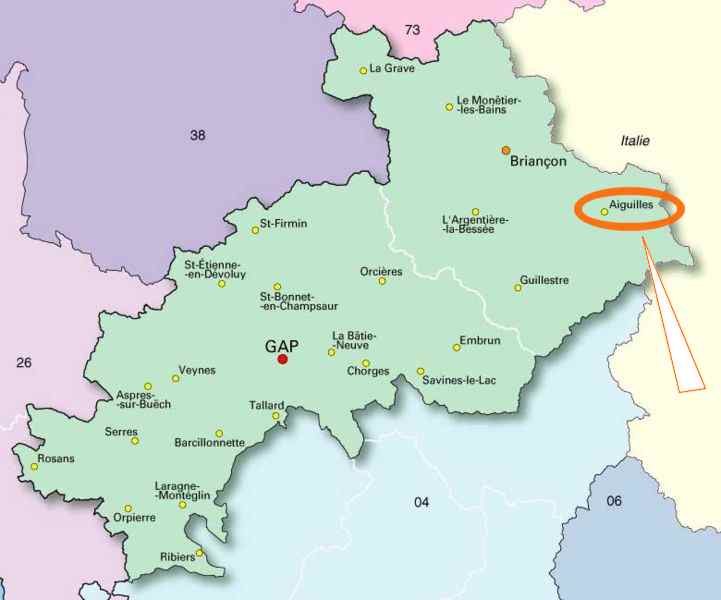
canton of Aiguilles
- canton of France
Hiking in canton of Aiguilles
The Canton of Aiguilles is a beautiful area located in the French Alps, known for its stunning natural landscapes, rugged mountain terrain, and opportunities for outdoor activities, particularly hiking. Here’s what you can expect when hiking in this picturesque region:...


canton of Guillestre
- canton of France
Hiking in canton of Guillestre
The Canton of Guillestre, located in the Hautes-Alpes department in southeastern France, is a fantastic destination for hiking enthusiasts. Nestled in the stunning French Alps, the area is characterized by dramatic mountain landscapes, clear rivers, and rich biodiversity....
- Country:
- Capital: Guillestre
- Coordinates: 44° 40' 0" N, 6° 39' 0" E
- GPS tracks (wikiloc): [Link]
- Population: 7946

canton of La Grave
- canton of France
Hiking in canton of La Grave
The Canton of La Grave, located in the French Alps, is a stunning destination for hiking enthusiasts. Nestled in the Haute Alpes department, this area is known for its breathtaking scenery, diverse landscapes, and a variety of hiking options ranging from leisurely walks to challenging treks....


canton of L'Argentière-la-Bessée
- canton of France
Hiking in canton of L'Argentière-la-Bessée
Canton of L'Argentière-la-Bessée, located in the Hautes-Alpes region of France, is a beautiful area for hiking, offering a variety of trails that cater to different experience levels. Nestled in the heart of the Écrins National Park, the region is characterized by its stunning alpine landscapes, picturesque villages, and diverse flora and fauna....
- Country:
- Capital: L'Argentière-la-Bessée
- Coordinates: 44° 47' 43" N, 6° 33' 36" E
- GPS tracks (wikiloc): [Link]
- Population: 6710