arrondissement of Metz-Campagne (arrondissement de Metz-Campagne)

- former arrondissement in eastern France
- Country:

- Capital: Metz
- Coordinates: 49° 7' 0" N, 6° 10' 0" E


- GPS tracks (wikiloc): [Link]
- Wikipedia en: wiki(en)
- Wikipedia: wiki(fr)
- Wikidata storage: Wikidata: Q701694
- Freebase ID: [/m/0956hn]
- GeoNames ID: Alt: [2994159]
- OSM relation ID: [2402059]
- INSEE arrondissement code: [574]
Includes regions:

canton of Maizières-lès-Metz
- canton of France (until March 2015)
- Country:
- Capital: Maizières-lès-Metz
- Coordinates: 49° 13' 18" N, 6° 9' 40" E
- GPS tracks (wikiloc): [Link]

canton of Verny
- canton of France (until March 2015)
- Country:
- Capital: Verny
- Coordinates: 48° 59' 56" N, 6° 13' 5" E
- GPS tracks (wikiloc): [Link]
- Population: 29219

canton of Montigny-lès-Metz
- canton of France
- Country:
- Capital: Montigny-lès-Metz
- Coordinates: 49° 7' 30" N, 6° 12' 7" E
- GPS tracks (wikiloc): [Link]
- Population: 44409

canton of Ars-sur-Moselle
- canton of France (until March 2015)
- Country:
- Capital: Ars-sur-Moselle
- Coordinates: 49° 4' 50" N, 6° 3' 5" E
- GPS tracks (wikiloc): [Link]

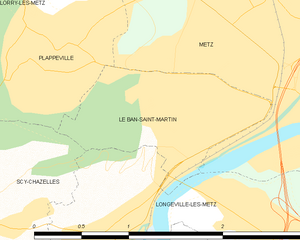
Le Ban-Saint-Martin
- commune in Moselle, France
- Country:
- Postal Code: 57050
- Coordinates: 49° 7' 19" N, 6° 9' 2" E
- GPS tracks (wikiloc): [Link]
- Area: 1.59 sq km
- Population: 4164
- Web site: [Link]

canton of Rombas
- canton of France
- Country:
- Capital: Rombas
- Coordinates: 49° 15' 23" N, 6° 7' 4" E
- GPS tracks (wikiloc): [Link]
- Population: 44505

canton of Marange-Silvange
- canton of France (until March 2015)
- Country:
- Capital: Marange-Silvange
- Coordinates: 49° 11' 33" N, 6° 4' 24" E
- GPS tracks (wikiloc): [Link]