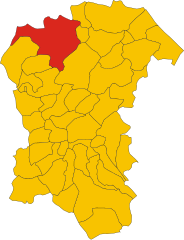
Arsita (Arsita)
.svg)
- Italian comune
 Hiking in Arsita
Arsita is a charming village located in the Teramo province of the Abruzzo region in Italy. It is nestled in the beautiful Gran Sasso and Monti della Laga National Park, which offers a range of hiking opportunities for outdoor enthusiasts.
Hiking Highlights in Arsita:
-
Scenic Trails: The trails around Arsita provide stunning views of the surrounding mountains and valleys. Depending on the route, hikers may encounter lush forests, rocky outcrops, and panoramic vistas.
-
Gran Sasso and Monti della Laga National Park: This national park is one of the largest protected areas in Italy, featuring diverse ecosystems, steep peaks, and a wide variety of flora and fauna. Trails vary in difficulty, catering to both beginners and experienced hikers.
-
Cultural Sites: Along your hikes, you can explore historical and cultural sites, such as old churches, ruins, and traditional stone houses. This adds an enriching historical context to your outdoor experience.
-
Wildlife Watching: The region is home to numerous wildlife species, including deer, wolves, and various birds. Early morning hikes can provide opportunities for wildlife observation.
-
Local Gastronomy: If your hiking trip coincides with your mealtime, be sure to enjoy local Abruzzese cuisine in Arsita itself or nearby towns. Traditional dishes often feature game, cereals, and local cheeses.
Tips for Hiking in Arsita:
-
Preparation: Ensure you have proper hiking gear, including sturdy boots, weather-appropriate clothing, and sufficient water and snacks.
-
Map and GPS: While the trails are often marked, having a map or a GPS device can help prevent getting lost.
-
Weather Considerations: Check the weather forecast before heading out, as conditions can change rapidly in the mountains.
-
Local Guides: If you're unfamiliar with the area, consider hiring a local guide who can share valuable insights and ensure a safe experience.
-
Respect Nature: Follow the principle of "Leave No Trace" to preserve the natural beauty of the area. Be mindful of wildlife and stick to designated paths.
Overall, hiking in Arsita is a rewarding experience, blending natural beauty with cultural richness. Enjoy your adventure!
- Country:

- Postal Code: 64031
- Local Dialing Code: 0861
- Licence Plate Code: TE
- Coordinates: 42° 30' 8" N, 13° 47' 4" E


- GPS tracks (wikiloc): [Link]
- AboveSeaLevel: 470 м m
- Area: 34.14 sq km
- Population: 812
- Web site: http://tecuting.it/c067003/hh/index.php?lang_eg=2
- Wikipedia en: wiki(en)
- Wikipedia: wiki(it)
- Wikidata storage: Wikidata: Q51419
- Wikipedia Commons Category: [Link]
- Freebase ID: [/m/0frk4w]
- GeoNames ID: Alt: [6538855]
- VIAF ID: Alt: [304916665]
- OSM relation ID: [42025]
- ISTAT ID: 067003
- Italian cadastre code: A445
Shares border with regions:


Castel del Monte, Abruzzo
- Italian comune
Hiking in Castel del Monte, Abruzzo
Castel del Monte, located in the Abruzzo region of Italy, is a beautiful area known for its stunning landscapes, rich cultural heritage, and diverse hiking opportunities. Here’s a guide to hiking in the region:...
- Country:
- Postal Code: 67023
- Local Dialing Code: 0862
- Licence Plate Code: AQ
- Coordinates: 42° 21' 56" N, 13° 43' 33" E
- GPS tracks (wikiloc): [Link]
- AboveSeaLevel: 1346 м m
- Area: 58.03 sq km
- Population: 437
- Web site: [Link]


Farindola
- Italian comune
Hiking in Farindola
Farindola is a charming village located in the Gran Sasso e Monti della Laga National Park in Italy, offering a variety of hiking opportunities that cater to different skill levels and preferences. The surrounding landscape is characterized by stunning mountain scenery, rich biodiversity, and numerous trails that explore both natural and cultural sites. Here are some aspects to consider when hiking in and around Farindola:...
- Country:
- Postal Code: 65010
- Local Dialing Code: 085
- Licence Plate Code: PE
- Coordinates: 42° 26' 30" N, 13° 49' 21" E
- GPS tracks (wikiloc): [Link]
- AboveSeaLevel: 530 м m
- Area: 45.47 sq km
- Population: 1456
- Web site: [Link]

Penne, Abruzzo
- Italian comune
Hiking in Penne, Abruzzo
Hiking in Penne, a charming town in the Abruzzo region of Italy, offers you a rich blend of natural beauty, historical significance, and cultural experiences. Here are some highlights and tips for hiking in this picturesque area:...
- Country:
- Postal Code: 65017
- Local Dialing Code: 085
- Licence Plate Code: PE
- Coordinates: 42° 27' 0" N, 13° 55' 0" E
- GPS tracks (wikiloc): [Link]
- AboveSeaLevel: 438 м m
- Area: 91.2 sq km
- Population: 12113
- Web site: [Link]

Bisenti
- Italian comune
Hiking in Bisenti
Bisenti is a charming town located in the Abruzzo region of Italy, surrounded by beautiful landscapes that are perfect for hiking enthusiasts. The area offers a mix of natural beauty, historical sites, and local culture, making it an excellent destination for hikers of all levels. Here are some highlights of hiking in and around Bisenti:...
- Country:
- Postal Code: 64033
- Local Dialing Code: 0861
- Licence Plate Code: TE
- Coordinates: 42° 32' 0" N, 13° 48' 0" E
- GPS tracks (wikiloc): [Link]
- AboveSeaLevel: 274 м m
- Area: 30.88 sq km
- Population: 1885
- Web site: [Link]

Castelli, Abruzzo
- Italian comune
Hiking in Castelli, Abruzzo
Castelli, located in the province of Teramo in the Abruzzo region of Italy, is a picturesque village known for its stunning landscapes and rich history. It's surrounded by the Gran Sasso e Monti della Laga National Park, which offers a variety of hiking opportunities suited for different skill levels. Here are some highlights you might consider when planning a hiking trip in this beautiful area:...
- Country:
- Postal Code: 64041
- Local Dialing Code: 0861
- Licence Plate Code: TE
- Coordinates: 42° 29' 5" N, 13° 42' 43" E
- GPS tracks (wikiloc): [Link]
- AboveSeaLevel: 497 м m
- Area: 49.68 sq km
- Population: 1098
- Web site: [Link]