
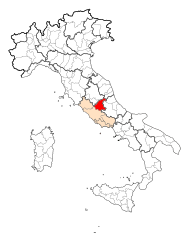
Province of Teramo (provincia di Teramo)

- province of Italy
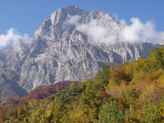
 Hiking in Province of Teramo
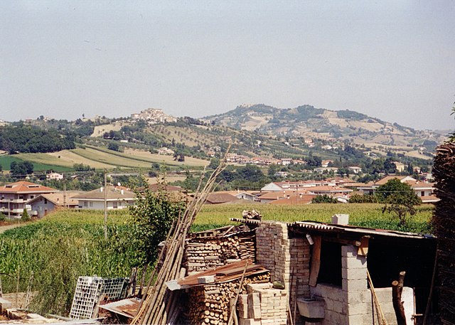
The Province of Teramo, located in the Abruzzo region of Italy, offers stunning landscapes, rich cultural heritage, and a variety of hiking opportunities. Here are some key highlights for hiking in this beautiful province:
1.
This park is home to the highest peak of the Apennines, Corno Grande, which offers challenging hikes and breathtaking views. The park features a network of trails that vary in difficulty, from easy walks to more strenuous climbs. Popular routes include:
- The Summit of Corno Grande: A rewarding hike with stunning panoramic views.
- Machinario Trail: An easier path that takes you through picturesque landscapes.
2.
While primarily located in nearby regions, the trails leading to and from this park can be accessed from Teramo. The Majella Mountain range offers unique geological formations, valleys, and rich flora and fauna.
3.
This coastal area around San Benedetto del Tronto has several shorter trails that allow for varied experiences, from beach walks to wetland exploration. It’s a great place for wildlife enthusiasts and offers a different perspective of the region’s natural beauty.
4.
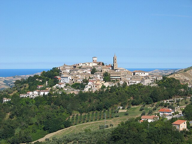
Hiking around this historic town not only provides scenic views but also an exploration of the historical sites and architecture. The trails around Civitella lead you through olive groves and vineyards, with opportunities to stop and sample local wines.
5.
The hills surrounding the city of Teramo offer many trails that are ideal for day hikes. You can explore local vineyards, olive orchards, and charming villages. A hike in this area can combine natural beauty with cultural artifacts.
6.
Many trails also lead to ancient sites, such as Roman ruins and medieval villages, allowing hikers to combine exercise with a sense of history. Some trails may lead to places like the ancient town of Notaresco or along the Vestine hills.
- Best Time to Hike: Spring (April to June) and Fall (September to October) are ideal due to milder weather and beautiful landscapes.
- Gear: Wear suitable hiking boots, and carry plenty of water, snacks, and a detailed map or GPS.
- Respect Nature: Follow the Leave No Trace principles by staying on trails and not disturbing wildlife.
- Check Local Conditions: Some trails may be affected by seasonal weather conditions, so it's wise to check before heading out.
With stunning vistas, rich biodiversity, and historical intrigue, Teramo Province is a fantastic destination for hikers of all abilities. Whether you're looking for a challenge in the mountains or a leisurely hike through rolling hills, you'll find plenty to explore in this diverse region.
- Country:

- Capital: Teramo
- Postal Code: 64100
- Licence Plate Code: TE
- Coordinates: 42° 39' 31" N, 13° 42' 9" E


- GPS tracks (wikiloc): [Link]
- Area: 1947.64 sq km
- Web site: http://www.provincia.teramo.it/
- Wikipedia en: wiki(en)
- Wikipedia: wiki(it)
- Wikidata storage: Wikidata: Q16284
- Wikipedia Commons Gallery: [Link]
- Wikipedia Commons Category: [Link]
- Freebase ID: [/m/041ksh]
- GeoNames ID: Alt: [3165802]
- BnF ID: [12357223w]
- VIAF ID: Alt: [156888109]
- GND ID: Alt: [4458707-7]
- archINFORM location ID: [7738]
- PACTOLS thesaurus ID: [pcrt5BtxKO08MQ]
- TGN ID: [7003001]
- Encyclopædia Britannica Online ID: [place/Teramo-province-Italy]
- DMOZ ID: Alt: [Regional/Europe/Italy/Regions/Abruzzo/Provinces/Teramo/]
- NUTS code: [ITF12]
- ISTAT ID: 067
- ISO 3166-2 code: IT-TE
Includes regions:

Teramo
- Italian comune
Hiking in Teramo
Teramo, located in the Abruzzo region of Italy, is an excellent destination for hiking enthusiasts. The area is characterized by its diverse landscapes, which include rugged mountains, rolling hills, and beautiful coastlines. Here are some highlights and considerations for hiking in and around Teramo:...
- Country:
- Postal Code: 64100
- Local Dialing Code: 0861
- Licence Plate Code: TE
- Coordinates: 42° 39' 32" N, 13° 42' 14" E
- GPS tracks (wikiloc): [Link]
- AboveSeaLevel: 265 м m
- Area: 153 sq km
- Population: 54857
- Web site: [Link]

Roseto degli Abruzzi
- Italian comune
Hiking in Roseto degli Abruzzi
Roseto degli Abruzzi, located along the Adriatic coast in Italy's Abruzzo region, is not just known for its beautiful beaches but also for its proximity to the stunning natural landscapes of the Abruzzo National Park and surrounding areas. Here's what you need to know about hiking around Roseto degli Abruzzi:...
- Country:
- Postal Code: 64026
- Local Dialing Code: 085
- Licence Plate Code: TE
- Coordinates: 42° 41' 0" N, 14° 1' 0" E
- GPS tracks (wikiloc): [Link]
- AboveSeaLevel: 5 м m
- Area: 53.27 sq km
- Population: 25588
- Web site: [Link]

Alba Adriatica
- Italian comune
Hiking in Alba Adriatica
Alba Adriatica is primarily known as a beach resort town located on the Adriatic Sea in the Abruzzo region of Italy. While it is celebrated for its lovely sandy beaches and vibrant beachfront promenade, hiking in and around Alba Adriatica offers beautiful landscapes and opportunities to explore the natural beauty of the surrounding area....
- Country:
- Postal Code: 64011
- Local Dialing Code: 0861
- Licence Plate Code: TE
- Coordinates: 42° 50' 0" N, 13° 55' 0" E
- GPS tracks (wikiloc): [Link]
- AboveSeaLevel: 5 м m
- Area: 9.6 sq km
- Population: 12462
- Web site: [Link]

Ancarano
- Italian comune
Hiking in Ancarano
Ancarano, a small town in the Abruzzo region of Italy, is surrounded by beautiful natural landscapes that offer great opportunities for hiking enthusiasts. The area is characterized by rolling hills, lush greenery, and stunning views of the Gran Sasso and Monti della Laga National Park, making it an ideal destination for outdoor activities....
- Country:
- Postal Code: 64010
- Local Dialing Code: 0861
- Licence Plate Code: TE
- Coordinates: 42° 50' 13" N, 13° 44' 25" E
- GPS tracks (wikiloc): [Link]
- AboveSeaLevel: 294 м m
- Area: 13.92 sq km
- Population: 1890
- Web site: [Link]
Arsita
- Italian comune
Hiking in Arsita
Arsita is a charming village located in the Teramo province of the Abruzzo region in Italy. It is nestled in the beautiful Gran Sasso and Monti della Laga National Park, which offers a range of hiking opportunities for outdoor enthusiasts....
- Country:
- Postal Code: 64031
- Local Dialing Code: 0861
- Licence Plate Code: TE
- Coordinates: 42° 30' 8" N, 13° 47' 4" E
- GPS tracks (wikiloc): [Link]
- AboveSeaLevel: 470 м m
- Area: 34.14 sq km
- Population: 812
- Web site: [Link]

Atri, Abruzzo
- Italian comune
Hiking in Atri, Abruzzo
Atri, Located in the Abruzzo region of Italy, is a charming medieval town that offers a unique blend of cultural heritage and natural beauty, making it a fantastic destination for hiking enthusiasts. Here are some key points about hiking in and around Atri:...
- Country:
- Postal Code: 64032
- Local Dialing Code: 085
- Licence Plate Code: TE
- Coordinates: 42° 35' 0" N, 13° 59' 0" E
- GPS tracks (wikiloc): [Link]
- AboveSeaLevel: 442 м m
- Area: 92.18 sq km
- Population: 10635
- Web site: [Link]
Basciano
- Italian comune
Hiking in Basciano
Basciano is a small town located in the Abruzzo region of Italy. While it may not be as widely known for hiking as some larger areas, it is surrounded by beautiful landscapes typical of the Abruzzo region, which is known for its natural parks, mountains, and outdoor activities....
- Country:
- Postal Code: 64030
- Local Dialing Code: 0861
- Licence Plate Code: TE
- Coordinates: 42° 35' 47" N, 13° 44' 8" E
- GPS tracks (wikiloc): [Link]
- AboveSeaLevel: 388 м m
- Area: 18.85 sq km
- Population: 2373
- Web site: [Link]

Bellante
- Italian comune
Hiking in Bellante
Bellante is a charming municipality located in the Teramo province of the Abruzzo region in Italy. The area boasts beautiful landscapes, rolling hills, and a rich cultural heritage, making it a great destination for hikers....
- Country:
- Postal Code: 64020
- Local Dialing Code: 0861
- Licence Plate Code: TE
- Coordinates: 42° 45' 0" N, 13° 48' 0" E
- GPS tracks (wikiloc): [Link]
- AboveSeaLevel: 354 м m
- Area: 50.04 sq km
- Population: 6997
- Web site: [Link]

Bisenti
- Italian comune
Hiking in Bisenti
Bisenti is a charming town located in the Abruzzo region of Italy, surrounded by beautiful landscapes that are perfect for hiking enthusiasts. The area offers a mix of natural beauty, historical sites, and local culture, making it an excellent destination for hikers of all levels. Here are some highlights of hiking in and around Bisenti:...
- Country:
- Postal Code: 64033
- Local Dialing Code: 0861
- Licence Plate Code: TE
- Coordinates: 42° 32' 0" N, 13° 48' 0" E
- GPS tracks (wikiloc): [Link]
- AboveSeaLevel: 274 м m
- Area: 30.88 sq km
- Population: 1885
- Web site: [Link]

Campli
- Italian comune
Hiking in Campli
Campli, a charming town located in the Abruzzo region of Italy, offers some beautiful hiking opportunities amidst stunning landscapes, historical sites, and natural parks. Here are some key points to consider if you are planning a hiking trip in and around Campli:...
- Country:
- Postal Code: 64012
- Local Dialing Code: 0861
- Licence Plate Code: TE
- Coordinates: 42° 43' 34" N, 13° 41' 10" E
- GPS tracks (wikiloc): [Link]
- AboveSeaLevel: 393 м m
- Area: 73.43 sq km
- Population: 7110
- Web site: [Link]

Canzano
- Italian comune
Hiking in Canzano
Canzano is a small town located in the Abruzzo region of Italy, known for its beautiful landscapes and proximity to the Gran Sasso e Monti della Laga National Park. The park offers a variety of hiking trails that cater to different experience levels, making it an excellent destination for hikers....
- Country:
- Postal Code: 64020
- Local Dialing Code: 0861
- Licence Plate Code: TE
- Coordinates: 42° 39' 0" N, 13° 48' 0" E
- GPS tracks (wikiloc): [Link]
- AboveSeaLevel: 448 м m
- Area: 16.74 sq km
- Population: 1901
- Web site: [Link]

Castel Castagna
- Italian comune
Hiking in Castel Castagna
Castel Castagna is a picturesque village located in the Teramo province of the Abruzzo region in Italy. Known for its stunning landscapes and rich natural heritage, it offers a variety of hiking opportunities for outdoor enthusiasts....
- Country:
- Postal Code: 64030
- Local Dialing Code: 0861
- Licence Plate Code: TE
- Coordinates: 42° 33' 0" N, 13° 43' 0" E
- GPS tracks (wikiloc): [Link]
- AboveSeaLevel: 452 м m
- Area: 18.16 sq km
- Population: 490
- Web site: [Link]

Castellalto
- Italian comune
Hiking in Castellalto
Castellalto, located in the Abruzzo region of Italy, offers a variety of hiking opportunities that cater to different skill levels and preferences. The region is characterized by stunning landscapes, including hills, vineyards, and picturesque views of the surrounding mountains and valleys....
- Country:
- Postal Code: 64020
- Local Dialing Code: 0861
- Licence Plate Code: TE
- Coordinates: 42° 40' 38" N, 13° 49' 4" E
- GPS tracks (wikiloc): [Link]
- AboveSeaLevel: 492 м m
- Area: 34.18 sq km
- Population: 7578
- Web site: [Link]

Castelli, Abruzzo
- Italian comune
Hiking in Castelli, Abruzzo
Castelli, located in the province of Teramo in the Abruzzo region of Italy, is a picturesque village known for its stunning landscapes and rich history. It's surrounded by the Gran Sasso e Monti della Laga National Park, which offers a variety of hiking opportunities suited for different skill levels. Here are some highlights you might consider when planning a hiking trip in this beautiful area:...
- Country:
- Postal Code: 64041
- Local Dialing Code: 0861
- Licence Plate Code: TE
- Coordinates: 42° 29' 5" N, 13° 42' 43" E
- GPS tracks (wikiloc): [Link]
- AboveSeaLevel: 497 м m
- Area: 49.68 sq km
- Population: 1098
- Web site: [Link]
Castiglione Messer Raimondo
- Italian comune
Hiking in Castiglione Messer Raimondo
Castiglione Messer Raimondo is a charming hilltop town located in the Abruzzo region of Italy. It offers stunning landscapes, rich history, and a variety of hiking opportunities that cater to different skill levels. Here are some highlights of hiking in this area:...
- Country:
- Postal Code: 64034
- Local Dialing Code: 0861
- Licence Plate Code: TE
- Coordinates: 42° 32' 0" N, 13° 53' 0" E
- GPS tracks (wikiloc): [Link]
- AboveSeaLevel: 306 м m
- Area: 30.69 sq km
- Population: 2247
- Web site: [Link]
Castilenti
- Italian comune
Hiking in Castilenti
Castilenti is a charming town located in the Abruzzo region of Italy, nestled in the foothills of the Apennine Mountains. The area is known for its scenic beauty, rich history, and the variety of outdoor activities it offers, including hiking....
- Country:
- Postal Code: 64035
- Local Dialing Code: 0861
- Licence Plate Code: TE
- Coordinates: 42° 32' 0" N, 13° 55' 0" E
- GPS tracks (wikiloc): [Link]
- AboveSeaLevel: 272 м m
- Area: 23.79 sq km
- Population: 1419
- Web site: [Link]
Cellino Attanasio
- Italian comune
Hiking in Cellino Attanasio
Cellino Attanasio is a charming town located in the Abruzzo region of Italy, known for its picturesque landscapes, rolling hills, and rural charm. While it may not be as widely recognized as some other hiking destinations, it offers a variety of opportunities for outdoor enthusiasts looking to explore the natural beauty of the area....
- Country:
- Postal Code: 64036
- Local Dialing Code: 0861
- Licence Plate Code: TE
- Coordinates: 42° 35' 0" N, 13° 52' 0" E
- GPS tracks (wikiloc): [Link]
- AboveSeaLevel: 443 м m
- Area: 43.94 sq km
- Population: 2493
- Web site: [Link]

Cermignano
- Italian comune
Hiking in Cermignano
Cermignano, a charming town located in the Teramo province of Italy, offers a unique blend of natural beauty and cultural heritage. Here are some aspects to consider for hiking in and around Cermignano:...
- Country:
- Postal Code: 64037
- Local Dialing Code: 0861
- Licence Plate Code: TE
- Coordinates: 42° 35' 0" N, 13° 48' 0" E
- GPS tracks (wikiloc): [Link]
- AboveSeaLevel: 563 м m
- Area: 26.36 sq km
- Population: 1591
- Web site: [Link]

Civitella del Tronto
- Italian comune
Hiking in Civitella del Tronto
Civitella del Tronto is a charming hilltop village located in the Abruzzo region of Italy, known for its historical architecture and stunning natural surroundings. Hiking in this area offers a mix of cultural heritage and beautiful landscapes....
- Country:
- Postal Code: 64010
- Local Dialing Code: 0861
- Licence Plate Code: TE
- Coordinates: 42° 46' 19" N, 13° 40' 0" E
- GPS tracks (wikiloc): [Link]
- AboveSeaLevel: 589 м m
- Area: 77.74 sq km
- Population: 4918
- Web site: [Link]

Colledara
- Italian comune
Hiking in Colledara
Colledara is a picturesque town located in the Abruzzo region of Italy, known for its stunning landscapes and outdoor activities, particularly hiking. The area is characterized by rolling hills, beautiful valleys, and proximity to the Gran Sasso and Monti della Laga National Park, which makes it an excellent destination for hikers of all levels....
- Country:
- Postal Code: 64042
- Local Dialing Code: 0861
- Licence Plate Code: TE
- Coordinates: 42° 32' 0" N, 13° 41' 0" E
- GPS tracks (wikiloc): [Link]
- AboveSeaLevel: 430 м m
- Area: 18.01 sq km
- Population: 2151
- Web site: [Link]

Colonnella
- Italian comune
Hiking in Colonnella
Colonnella is a charming small town located in the Abruzzo region of Italy, near the Adriatic coast. The area surrounding Colonnella offers a variety of hiking opportunities that showcase the beautiful landscapes of the Apennine Mountains and the coastal views of the Adriatic Sea. Here are some highlights for hiking in and around Colonnella:...
- Country:
- Postal Code: 64010
- Local Dialing Code: 0735; 0861
- Licence Plate Code: TE
- Coordinates: 42° 52' 20" N, 13° 52' 12" E
- GPS tracks (wikiloc): [Link]
- AboveSeaLevel: 303 м m
- Area: 21.63 sq km
- Population: 3744
- Web site: [Link]
Controguerra
- Italian comune
Hiking in Controguerra
Controguerra is a small town located in the Abruzzo region of Italy, nestled between the Apennine mountains and the Adriatic Sea. It offers a range of hiking opportunities, combining beautiful landscapes with cultural experiences....
- Country:
- Postal Code: 64010
- Local Dialing Code: 0861
- Licence Plate Code: TE
- Coordinates: 42° 51' 0" N, 13° 49' 0" E
- GPS tracks (wikiloc): [Link]
- AboveSeaLevel: 267 м m
- Area: 22.82 sq km
- Population: 2365
- Web site: [Link]
Corropoli
- Italian comune
Hiking in Corropoli
Corropoli is a charming town located in the Abruzzo region of Italy, known for its picturesque scenery, rich history, and access to beautiful hiking trails. Hiking in and around Corropoli offers a unique opportunity to explore the stunning landscapes of the Apennines and the coastal areas nearby....
- Country:
- Postal Code: 64013
- Local Dialing Code: 0861
- Licence Plate Code: TE
- Coordinates: 42° 50' 0" N, 13° 50' 0" E
- GPS tracks (wikiloc): [Link]
- AboveSeaLevel: 132 м m
- Area: 22.11 sq km
- Population: 5054
- Web site: [Link]

Cortino
- Italian comune
Hiking in Cortino
Cortino, located in the province of Teramo in the Abruzzo region of Italy, is surrounded by beautiful natural landscapes, making it a great destination for hiking enthusiasts. The area is characterized by its stunning mountainous terrain, lush forests, and picturesque views of the Gran Sasso d'Italia and the Monti della Laga....
- Country:
- Postal Code: 64040
- Local Dialing Code: 0861
- Licence Plate Code: TE
- Coordinates: 42° 37' 19" N, 13° 30' 28" E
- GPS tracks (wikiloc): [Link]
- AboveSeaLevel: 892 м m
- Area: 62.95 sq km
- Population: 631
- Web site: [Link]

Crognaleto
- Italian comune
Hiking in Crognaleto
Crognaleto is a picturesque area located in the Abruzzo region of Italy, known for its stunning natural landscapes, beautiful mountains, and a variety of hiking trails that cater to different skill levels. The region is part of the Gran Sasso e Monti della Laga National Park, which provides a rich environment of biodiversity, including picturesque valleys, rugged peaks, and diverse flora and fauna....
- Country:
- Postal Code: 64043
- Local Dialing Code: 0861
- Licence Plate Code: TE
- Coordinates: 42° 35' 0" N, 13° 29' 0" E
- GPS tracks (wikiloc): [Link]
- AboveSeaLevel: 835 м m
- Area: 124.3 sq km
- Population: 1245
- Web site: [Link]

Fano Adriano
- Italian comune
Hiking in Fano Adriano
Fano Adriano, a small town in the Abruzzo region of Italy, offers a picturesque setting for hikers seeking to explore the natural beauty of the area. Nestled in the Gran Sasso and Monti della Laga National Park, this region boasts a variety of hiking trails suited for different skill levels, from leisurely walks to more challenging treks....
- Country:
- Postal Code: 64044
- Local Dialing Code: 0861
- Licence Plate Code: TE
- Coordinates: 42° 33' 14" N, 13° 32' 12" E
- GPS tracks (wikiloc): [Link]
- AboveSeaLevel: 745 м m
- Area: 35.77 sq km
- Population: 278
- Web site: [Link]

Giulianova
- Italian comune
Hiking in Giulianova
Giulianova, located along the Adriatic coast of Italy in the Abruzzo region, is a charming town known for its beautiful beaches and historical significance. While it is primarily a seaside resort, there are various hiking opportunities in the surrounding areas, particularly in the nearby Gran Sasso and Monti della Laga National Park and the Teramo province’s picturesque landscapes....
- Country:
- Postal Code: 64021
- Local Dialing Code: 085
- Licence Plate Code: TE
- Coordinates: 42° 45' 9" N, 13° 57' 24" E
- GPS tracks (wikiloc): [Link]
- AboveSeaLevel: 68 м m
- Area: 28 sq km
- Population: 23875
- Web site: [Link]

Isola del Gran Sasso d'Italia
- Italian comune
Hiking in Isola del Gran Sasso d'Italia
Isola del Gran Sasso d'Italia is a beautiful area in the Abruzzo region of Italy, known for its stunning mountainous landscapes, rich biodiversity, and a variety of hiking trails suitable for different skill levels. It’s part of the Gran Sasso e Monti della Laga National Park, the largest protected area in the Apennines....
- Country:
- Postal Code: 64045
- Local Dialing Code: 0861
- Licence Plate Code: TE
- Coordinates: 42° 30' 27" N, 13° 39' 28" E
- GPS tracks (wikiloc): [Link]
- AboveSeaLevel: 498 м m
- Area: 84.05 sq km
- Population: 4684
- Web site: [Link]

Martinsicuro
- Italian comune
Hiking in Martinsicuro
Martinsicuro, located along the Adriatic coast in the Abruzzo region of Italy, is primarily known for its beautiful beaches and coastal scenery. While it may not be as famous for hiking as some other regions of Italy, there are still opportunities for outdoor enthusiasts to explore the surrounding areas....
- Country:
- Postal Code: 64014
- Local Dialing Code: 0861
- Licence Plate Code: TE
- Coordinates: 42° 53' 6" N, 13° 54' 58" E
- GPS tracks (wikiloc): [Link]
- AboveSeaLevel: 2 м m
- Area: 14.66 sq km
- Population: 15992
- Web site: [Link]
Montefino
- Italian comune
Hiking in Montefino
Montefino is a charming village located in the Abruzzo region of Italy, surrounded by stunning landscapes and an array of hiking opportunities. The area boasts hills, forests, and scenic views of the Adriatic Sea, making it an excellent destination for outdoor enthusiasts....
- Country:
- Postal Code: 64030
- Local Dialing Code: 0861
- Licence Plate Code: TE
- Coordinates: 42° 33' 0" N, 13° 53' 0" E
- GPS tracks (wikiloc): [Link]
- AboveSeaLevel: 352 м m
- Area: 18.59 sq km
- Population: 1018
- Web site: [Link]
Montorio al Vomano
- Italian comune
Hiking in Montorio al Vomano
Montorio al Vomano is a charming town located in the Abruzzo region of Italy, surrounded by beautiful landscapes that make it an excellent destination for hiking enthusiasts. The area features a mix of mountainous terrain, lush forests, and scenic views, making it ideal for both casual hikers and more experienced trekkers....
- Country:
- Postal Code: 64046
- Local Dialing Code: 0861
- Licence Plate Code: TE
- Coordinates: 42° 35' 0" N, 13° 38' 0" E
- GPS tracks (wikiloc): [Link]
- AboveSeaLevel: 262 м m
- Area: 53.57 sq km
- Population: 8013
- Web site: [Link]

Morro d'Oro
- Italian comune
Hiking in Morro d'Oro
Morro d'Oro, located in the Abruzzo region of Italy, is a lesser-known destination for hiking enthusiasts. The area is characterized by rolling hills, scenic landscapes, and a mix of rural and natural beauty, making it suitable for various hiking experiences....
- Country:
- Postal Code: 64020
- Local Dialing Code: 085
- Licence Plate Code: TE
- Coordinates: 42° 40' 0" N, 13° 55' 0" E
- GPS tracks (wikiloc): [Link]
- AboveSeaLevel: 210 м m
- Area: 28.73 sq km
- Population: 3593
- Web site: [Link]

Mosciano Sant'Angelo
- Italian comune
Hiking in Mosciano Sant'Angelo
Mosciano Sant'Angelo is a charming town located in the Abruzzo region of Italy, which features a mix of beautiful landscapes, cultural heritage, and outdoor activities, including hiking. The area around Mosciano Sant'Angelo offers various hiking opportunities that cater to different skill levels and preferences....
- Country:
- Postal Code: 64023
- Local Dialing Code: 085
- Licence Plate Code: TE
- Coordinates: 42° 45' 0" N, 13° 53' 0" E
- GPS tracks (wikiloc): [Link]
- AboveSeaLevel: 227 м m
- Area: 48.45 sq km
- Population: 9316
- Web site: [Link]

Nereto
- Italian comune
Hiking in Nereto
Nereto, located in the Abruzzo region of Italy, is not just a picturesque town known for its historical buildings and beautiful landscapes; it also provides access to some wonderful hiking opportunities. The town is surrounded by the splendid Apennine mountains and offers various trails that cater to different skill levels, from casual walkers to experienced hikers....
- Country:
- Postal Code: 64015
- Local Dialing Code: 0861
- Licence Plate Code: TE
- Coordinates: 42° 49' 12" N, 13° 49' 1" E
- GPS tracks (wikiloc): [Link]
- AboveSeaLevel: 163 м m
- Area: 7.01 sq km
- Population: 5342
- Web site: [Link]

Notaresco
- Italian comune
Hiking in Notaresco
Notaresco is a quaint town located in the Abruzzo region of Italy, surrounded by beautiful countryside and hills that make it a great spot for hiking enthusiasts. Hiking in and around Notaresco offers a mix of scenic views, historical sites, and a chance to experience the rich natural biodiversity of the area....
- Country:
- Postal Code: 64024
- Local Dialing Code: 085
- Licence Plate Code: TE
- Coordinates: 42° 39' 0" N, 13° 54' 0" E
- GPS tracks (wikiloc): [Link]
- AboveSeaLevel: 267 м m
- Area: 38.15 sq km
- Population: 6702
- Web site: [Link]
Penna Sant'Andrea
- Italian comune
Hiking in Penna Sant'Andrea
Penna Sant'Andrea, located in the Abruzzo region of Italy, is a hidden gem for hiking enthusiasts. Nestled in the picturesque Apennine Mountains, this area offers stunning landscapes, rich biodiversity, and a range of hiking trails suitable for different skill levels....
- Country:
- Postal Code: 64039
- Local Dialing Code: 0861
- Licence Plate Code: TE
- Coordinates: 42° 36' 0" N, 13° 46' 0" E
- GPS tracks (wikiloc): [Link]
- AboveSeaLevel: 413 м m
- Area: 11.1 sq km
- Population: 1763
- Web site: [Link]

Pietracamela
- Italian comune
Hiking in Pietracamela
Pietracamela is a beautiful village located in the Abruzzo region of Italy, nestled at the foot of the Gran Sasso massif. This area is renowned for its stunning landscapes, diverse flora and fauna, and rich history, making it a great destination for hikers of all levels. Here are some key points to consider when hiking in Pietracamela:...
- Country:
- Postal Code: 64047
- Local Dialing Code: 0861
- Licence Plate Code: TE
- Coordinates: 42° 31' 23" N, 13° 33' 12" E
- GPS tracks (wikiloc): [Link]
- AboveSeaLevel: 1005 м m
- Area: 44.49 sq km
- Population: 251
- Web site: [Link]

Pineto
- Italian comune
Hiking in Pineto
Pineto is a beautiful coastal town located in the Abruzzo region of Italy, known for its natural beauty, charming landscapes, and scenic hiking trails. The area offers a variety of hiking opportunities that cater to different skill levels, making it an ideal destination for outdoor enthusiasts....
- Country:
- Postal Code: 64025
- Local Dialing Code: 085
- Licence Plate Code: TE
- Coordinates: 42° 37' 0" N, 14° 4' 0" E
- GPS tracks (wikiloc): [Link]
- AboveSeaLevel: 4 м m
- Area: 38.11 sq km
- Population: 14915
- Web site: [Link]

Rocca Santa Maria
- Italian comune
Hiking in Rocca Santa Maria
Rocca Santa Maria is a charming destination for hiking enthusiasts, located in the beautiful region of Abruzzo, Italy. Surrounded by the stunning landscapes of the Gran Sasso e Monti della Laga National Park, this area offers a variety of trails suitable for all levels of hikers....
- Country:
- Postal Code: 64010
- Local Dialing Code: 0861
- Licence Plate Code: TE
- Coordinates: 42° 41' 0" N, 13° 32' 0" E
- GPS tracks (wikiloc): [Link]
- AboveSeaLevel: 1073 м m
- Area: 61.8 sq km
- Population: 502
- Web site: [Link]
Sant'Egidio alla Vibrata
- Italian comune
Hiking in Sant'Egidio alla Vibrata
Sant'Egidio alla Vibrata is a quaint town located in the Abruzzo region of Italy, surrounded by picturesque landscapes that make it a great destination for hiking enthusiasts. The area is characterized by its rolling hills, lush valleys, and proximity to the Gran Sasso and Monti della Laga National Park, which offers numerous hiking trails with varying difficulty levels....
- Country:
- Postal Code: 64016
- Local Dialing Code: 0861
- Licence Plate Code: TE
- Coordinates: 42° 50' 0" N, 13° 43' 0" E
- GPS tracks (wikiloc): [Link]
- AboveSeaLevel: 239 м m
- Area: 18.36 sq km
- Population: 9753
- Web site: [Link]

Sant'Omero
- Italian comune
Hiking in Sant'Omero
Sant'Omero, located in the Abruzzo region of Italy, is a charming town known for its scenic beauty and proximity to the Monti della Laga National Park. Hiking in and around Sant'Omero offers a variety of trails that cater to different skill levels, giving you the opportunity to explore the stunning landscapes, rich biodiversity, and cultural heritage of the area....
- Country:
- Postal Code: 64027
- Local Dialing Code: 0861
- Licence Plate Code: TE
- Coordinates: 42° 47' 0" N, 13° 48' 0" E
- GPS tracks (wikiloc): [Link]
- AboveSeaLevel: 209 м m
- Area: 34.2 sq km
- Population: 5317
- Web site: [Link]

Silvi
- Italian comune
Hiking in Silvi
Silvi is a picturesque town located on the Adriatic coast in Italy, known for its stunning natural landscapes, rich cultural heritage, and relatively mild climate, making it an attractive destination for hiking enthusiasts. The region around Silvi offers a variety of trails that cater to different skill levels, from gentle coastal walks to more challenging inland routes....
- Country:
- Postal Code: 64028
- Local Dialing Code: 085
- Licence Plate Code: TE
- Coordinates: 42° 33' 0" N, 14° 7' 0" E
- GPS tracks (wikiloc): [Link]
- AboveSeaLevel: 2 м m
- Area: 20.63 sq km
- Population: 15708
- Web site: [Link]

Torano Nuovo
- Italian comune
Hiking in Torano Nuovo
Torano Nuovo is a small town located in the Abruzzo region of Italy, known for its scenic landscapes and proximity to the Gran Sasso and Monti della Laga National Park. While it may not be as well-known as some larger hiking destinations, it offers a variety of trails that can cater to both casual walkers and more experienced hikers....
- Country:
- Postal Code: 64010
- Local Dialing Code: 0861
- Licence Plate Code: TE
- Coordinates: 42° 49' 0" N, 13° 47' 0" E
- GPS tracks (wikiloc): [Link]
- AboveSeaLevel: 237 м m
- Area: 10.22 sq km
- Population: 1584
- Web site: [Link]

Torricella Sicura
- Italian comune
Hiking in Torricella Sicura
Torricella Sicura, located in the Abruzzo region of Italy, offers a beautiful landscape for hiking enthusiasts. Surrounded by the stunning views of the Gran Sasso and Monti della Laga National Park, which is not far from the village, the area features rugged mountains, rolling hills, and picturesque valleys....
- Country:
- Postal Code: 64010
- Local Dialing Code: 0861
- Licence Plate Code: TE
- Coordinates: 42° 39' 33" N, 13° 39' 26" E
- GPS tracks (wikiloc): [Link]
- AboveSeaLevel: 437 м m
- Area: 54.38 sq km
- Population: 2621
- Web site: [Link]

Tortoreto
- Italian comune
Hiking in Tortoreto
Tortoreto is a charming coastal town located in the Abruzzo region of Italy, known for its beautiful beaches and scenic landscapes. While it's primarily recognized for its seaside activities, there are also hiking opportunities in the surrounding areas that showcase the stunning natural beauty of the region....
- Country:
- Postal Code: 64018
- Local Dialing Code: 0861
- Licence Plate Code: TE
- Coordinates: 42° 48' 0" N, 13° 55' 0" E
- GPS tracks (wikiloc): [Link]
- AboveSeaLevel: 239 м m
- Area: 22.97 sq km
- Population: 11622
- Web site: [Link]
Tossicia
- Italian comune
Hiking in Tossicia
Tossicia is a charming town located in the Abruzzo region of Italy, surrounded by stunning landscapes and natural beauty, making it an appealing destination for hiking enthusiasts. The area features a variety of hiking trails suitable for different skill levels, allowing you to explore the picturesque mountains, forests, and valleys....
- Country:
- Postal Code: 64049
- Local Dialing Code: 0861
- Licence Plate Code: TE
- Coordinates: 42° 33' 0" N, 13° 39' 0" E
- GPS tracks (wikiloc): [Link]
- AboveSeaLevel: 409 м m
- Area: 27.14 sq km
- Population: 1333
- Web site: [Link]

Valle Castellana
- Italian comune
Hiking in Valle Castellana
Valle Castellana, located in the Abruzzo region of Italy, is a beautiful area known for its stunning landscapes and diverse hiking trails. The region is characterized by its mountainous terrain, rolling hills, and picturesque villages, providing a rich experience for outdoor enthusiasts....
- Country:
- Postal Code: 64010
- Local Dialing Code: 0861
- Licence Plate Code: TE
- Coordinates: 42° 44' 0" N, 13° 30' 0" E
- GPS tracks (wikiloc): [Link]
- AboveSeaLevel: 625 м m
- Area: 131.76 sq km
- Population: 952
- Web site: [Link]
Shares border with regions:


Province of Ascoli Piceno
- province in Italy
Hiking in Province of Ascoli Piceno
The Province of Ascoli Piceno, located in the Marche region of Italy, offers a diverse range of hiking opportunities, from rolling hills to rugged mountains, historic villages, and stunning landscapes. Here are some key highlights and tips for hiking in this beautiful province:...
- Country:
- Capital: Ascoli Piceno
- Postal Code: 63060–63100
- Local Dialing Code: 0736; 0734; 0735
- Licence Plate Code: AP
- Coordinates: 42° 51' 17" N, 13° 34' 31" E
- GPS tracks (wikiloc): [Link]
- Area: 2087.74 sq km
- Web site: [Link]
Province of L'Aquila
- province of Italy
Hiking in Province of L'Aquila
The Province of L'Aquila, located in the Abruzzo region of Italy, is a fantastic destination for hiking enthusiasts. Known for its diverse landscapes, it offers a variety of trails that range from easy walks to challenging mountain treks, appealing to hikers of all levels. Here are some highlights:...
- Country:
- Capital: L'Aquila
- Postal Code: 67066–67069; 67019–67041; 67017; 67012–67015; 67010; 67100
- Local Dialing Code: 0863; 0864; 0862
- Licence Plate Code: AQ
- Coordinates: 42° 25' 22" N, 13° 23' 40" E
- GPS tracks (wikiloc): [Link]
- Area: 5034.46 sq km
- Web site: [Link]

Province of Pescara
- province of Italy
Hiking in Province of Pescara
The Province of Pescara, located in the Abruzzo region of Italy, offers a variety of hiking opportunities that allow you to experience picturesque landscapes, diverse ecosystems, and charming villages. Here are some highlights and tips for hiking in this beautiful area:...
- Country:
- Capital: Pescara
- Postal Code: 65026–65029; 65022–65024; 65019–65020; 65016–65017; 65010–65014; 65121–65129
- Local Dialing Code: 085
- Licence Plate Code: PE
- Coordinates: 42° 27' 50" N, 14° 12' 51" E
- GPS tracks (wikiloc): [Link]
- Area: 1224.67 sq km
- Web site: [Link]

Province of Rieti
- province of Italy
Hiking in Province of Rieti
The Province of Rieti, located in the Lazio region of Italy, is a fantastic destination for hikers, thanks to its breathtaking landscapes, rich history, and diverse trails. Here are some highlights and recommendations for hiking in this beautiful area:...
- Country:
- Capital: Rieti
- Postal Code: 02010–02048; 02100
- Local Dialing Code: 0765; 0746; 0744
- Licence Plate Code: RI
- Coordinates: 42° 23' 55" N, 12° 51' 42" E
- GPS tracks (wikiloc): [Link]
- AboveSeaLevel: 405 м m
- Area: 2749.16 sq km
- Web site: [Link]