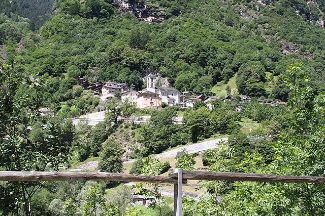
Arvigo (Arvigo)

- former municipality of Switzerland
 Hiking in Arvigo
Arvigo, a picturesque village in the canton of Graubünden, Switzerland, is known for its stunning landscapes and outdoor activities, making it a great destination for hiking enthusiasts. The area offers a variety of trails that cater to different skill levels, from easy walks to more challenging hikes.
Hiking Highlights in Arvigo:
-
Scenic Views: Hikes in Arvigo provide breathtaking views of the surrounding mountains, valleys, and the charming architecture of the village itself. The region's natural beauty is particularly striking in autumn when the foliage changes color.
-
Trail Options:
- Easy Trails: There are gentle paths suitable for families and beginners. These often lead to scenic viewpoints or along rivers.
- Moderate Trails: Some trails may take you through lush forests and meadows, offering a chance to experience local flora and fauna.
- Challenging Routes: Experienced hikers can find more rugged trails that climb higher into the mountains, offering a rewarding experience and panoramic vistas.
-
Coordinate with Weather: Weather can change rapidly in the mountains, so it's essential to check forecasts before heading out and to dress in layers.
-
Wildlife: Keep an eye out for local wildlife, including various bird species, chamois, and other mountain animals, making your hike a unique experience.
-
Cultural Aspects: Hiking in and around Arvigo allows you to explore traditional Swiss Alpine culture. You might encounter local cheese makers or unique architectural styles along your route.
-
Safety Precautions:
- Always let someone know your hiking plan.
- Carry sufficient water, snacks, and first-aid supplies.
- Ensure to have a good map or GPS for navigation.
-
Local Tips: It may be beneficial to visit the local tourist office for detailed maps, guided hike options, and any special events or seasonal activities. They often have excellent recommendations tailored to your preferences.
Conclusion:
Hiking in Arvigo is a rewarding experience that combines spectacular natural beauty with cultural exploration. Be sure to take your time, enjoy the scenery, and embrace the tranquility that the Swiss Alps offer. Happy hiking!
- Country:

- Postal Code: 6543
- Local Dialing Code: 091
- Licence Plate Code: GR
- Coordinates: 46° 18' 7" N, 9° 6' 45" E


- GPS tracks (wikiloc): [Link]
- AboveSeaLevel: 872 м m
- Area: 17.01 sq km
- Web site: http://www.arvigo.ch
- Wikipedia en: wiki(en)
- Wikipedia: wiki(de)
- Wikidata storage: Wikidata: Q66036
- Wikipedia Commons Category: [Link]
- Freebase ID: [/m/026ds0d]
- GeoNames ID: Alt: [7285104]
- VIAF ID: Alt: [311186678]
- GND ID: Alt: [105936042X]
- HDS ID: [1548]
- Swiss municipality code: [3801]
Shares border with regions:

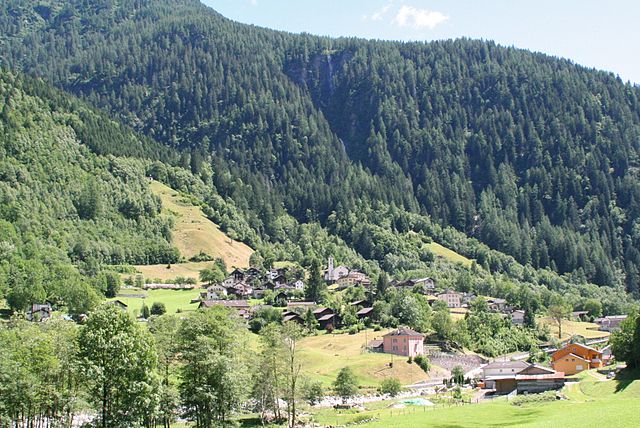
Buseno
- municipality in Switzerland
Hiking in Buseno
Buseno is a small, picturesque village located in the southern part of Switzerland, particularly in the canton of Graubünden. It's known for its stunning landscapes, mountainous terrain, and tranquil atmosphere, making it an excellent destination for hiking enthusiasts....
- Country:
- Postal Code: 6542
- Local Dialing Code: 091
- Licence Plate Code: GR
- Coordinates: 46° 16' 23" N, 9° 6' 26" E
- GPS tracks (wikiloc): [Link]
- AboveSeaLevel: 801 м m
- Area: 11.15 sq km
- Population: 83
- Web site: [Link]


San Vittore
- municipality in Graubünden, Switzerland
Hiking in San Vittore
San Vittore, located in the canton of Graubünden in Switzerland, offers a variety of hiking opportunities amidst stunning alpine scenery. Here’s an overview of what to expect when hiking in this beautiful region:...
- Country:
- Postal Code: 6534
- Local Dialing Code: 091
- Licence Plate Code: GR
- Coordinates: 46° 14' 17" N, 9° 6' 22" E
- GPS tracks (wikiloc): [Link]
- AboveSeaLevel: 688 м m
- Area: 22.06 sq km
- Population: 825
- Web site: [Link]


Cauco
- former municipality of Switzerland
Hiking in Cauco
Cauco, a beautiful and less-traveled area, offers a variety of hiking experiences characterized by stunning landscapes, diverse ecosystems, and rich cultural experiences. While specific trails can vary based on the exact location within Cauco, I can provide general information that may help you plan your hiking adventure in this region....
- Country:
- Postal Code: 6546
- Local Dialing Code: 091
- Licence Plate Code: GR
- Coordinates: 46° 20' 7" N, 9° 7' 15" E
- GPS tracks (wikiloc): [Link]
- AboveSeaLevel: 1057 м m
- Area: 10.89 sq km
- Web site: [Link]

Selma
- village in Graubünden, Switzerland
Hiking in Selma
Selma, located in the beautiful region of Graubünden in Switzerland, is surrounded by stunning alpine scenery, making it an excellent destination for hiking enthusiasts. Here’s what you can expect when hiking in and around Selma:...
- Country:
- Postal Code: 6545
- Local Dialing Code: 091
- Licence Plate Code: GR
- Coordinates: 46° 18' 59" N, 9° 7' 0" E
- GPS tracks (wikiloc): [Link]
- AboveSeaLevel: 977 м m
- Area: 2.91 sq km
- Web site: [Link]
Braggio
- former municipality of Switzerland
Hiking in Braggio
Braggio is a small village located in the beautiful region of Ticino, Switzerland, known for its stunning natural landscapes and hiking opportunities. If you're considering hiking in and around Braggio, here are some key points to keep in mind:...
- Country:
- Postal Code: 6544
- Local Dialing Code: 091
- Licence Plate Code: GR
- Coordinates: 46° 18' 11" N, 9° 7' 27" E
- GPS tracks (wikiloc): [Link]
- AboveSeaLevel: 1324 м m
- Area: 6.91 sq km
- Web site: [Link]


Osogna
- municipality in the canton of Ticino, Switzerland
Hiking in Osogna
Osogna is a charming village located in the Ticino canton of Switzerland, known for its stunning natural landscapes, rich history, and proximity to various hiking trails. It's a great starting point for exploring the beautiful surrounding areas, including the scenic Ticino region. Here are some highlights of hiking in and around Osogna:...
- Country:
- Postal Code: 6703
- Local Dialing Code: 091
- Licence Plate Code: TI
- Coordinates: 46° 19' 34" N, 9° 1' 16" E
- GPS tracks (wikiloc): [Link]
- AboveSeaLevel: 1196 м m
- Area: 18.97 sq km
- Web site: [Link]
Cresciano
- former municipality in the canton of Ticino, Switzerland
Hiking in Cresciano
Cresciano, located in the scenic Ticino region of Switzerland, offers a variety of hiking opportunities characterized by beautiful landscapes, charming villages, and rich natural diversity. Here are some highlights and tips for hiking in Cresciano:...
- Country:
- Postal Code: 6705
- Local Dialing Code: 091
- Licence Plate Code: TI
- Coordinates: 46° 18' 12" N, 9° 1' 59" E
- GPS tracks (wikiloc): [Link]
- AboveSeaLevel: 1655 м m
- Area: 17.19 sq km
- Web site: [Link]