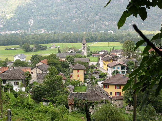
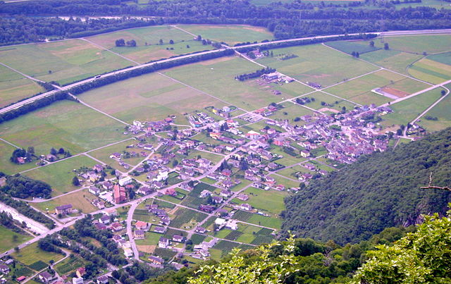
Cresciano (Cresciano)
- former municipality in the canton of Ticino, Switzerland
Cresciano, located in the scenic Ticino region of Switzerland, offers a variety of hiking opportunities characterized by beautiful landscapes, charming villages, and rich natural diversity. Here are some highlights and tips for hiking in Cresciano:
Hiking Trails
-
Crescia Waterfall Trail: A relatively easy hike that leads to beautiful waterfalls. This trail is perfect for families and those looking to enjoy a leisurely stroll amidst nature.
-
Monte Ceneri: For those seeking a more challenging hike, the trail leading up to Monte Ceneri provides stunning panoramic views of the surrounding valleys and mountains.
-
Gola di Biasca: A more strenuous option, this trail winds through dramatic gorges and offers breathtaking views along the way. Be sure to check the weather conditions before setting out, as this area can be rugged.
-
Path of the Ridges: This trail offers a spectacular view of the surrounding landscape and is ideal for those looking to connect with nature while experiencing varied terrains.
Tips for Hiking in Cresciano
- Check the Weather: Weather in the region can change rapidly. Always check the forecast before heading out, and dress in layers.
- Trail Maps: Although many trails are well-marked, it’s still a good idea to carry a trail map or a GPS device.
- Hydration and Snacks: Be sure to carry enough water and snacks, especially on longer hikes.
- Local Guides: Consider hiring a local guide if you're unfamiliar with the trails or want to learn more about the area's ecology and history.
- Respect Nature: Stick to marked trails, pack out what you pack in, and be respectful of wildlife.
Accessibility
Cresciano has good access points to several hiking trails. Public transport and well-maintained roads connect it to nearby towns and cities, making it easy to reach the starting points of various trails.
Hiking in Cresciano not only provides an opportunity for exercise but also allows you to immerse yourself in the stunning natural beauty of Switzerland. Enjoy your adventure!
- Country:

- Postal Code: 6705
- Local Dialing Code: 091
- Licence Plate Code: TI
- Coordinates: 46° 18' 12" N, 9° 1' 59" E


- GPS tracks (wikiloc): [Link]
- AboveSeaLevel: 1655 м m
- Area: 17.19 sq km
- Web site: http://www.cresciano.ch
- Wikipedia en: wiki(en)
- Wikipedia: wiki(de)
- Wikidata storage: Wikidata: Q67766
- Wikipedia Commons Category: [Link]
- Freebase ID: [/m/0gx056]
- GeoNames ID: Alt: [7285590]
- VIAF ID: Alt: [133886182]
- OSM relation ID: [1684669]
- GND ID: Alt: [4679990-4]
- HDS ID: [2250]
- Swiss municipality code: [5283]
Shares border with regions:


San Vittore
- municipality in Graubünden, Switzerland
San Vittore, located in the canton of Graubünden in Switzerland, offers a variety of hiking opportunities amidst stunning alpine scenery. Here’s an overview of what to expect when hiking in this beautiful region:...
- Country:

- Postal Code: 6534
- Local Dialing Code: 091
- Licence Plate Code: GR
- Coordinates: 46° 14' 17" N, 9° 6' 22" E


- GPS tracks (wikiloc): [Link]
- AboveSeaLevel: 688 м m
- Area: 22.06 sq km
- Population: 825
- Web site: [Link]


Arvigo
- former municipality of Switzerland
Arvigo, a picturesque village in the canton of Graubünden, Switzerland, is known for its stunning landscapes and outdoor activities, making it a great destination for hiking enthusiasts. The area offers a variety of trails that cater to different skill levels, from easy walks to more challenging hikes....
- Country:

- Postal Code: 6543
- Local Dialing Code: 091
- Licence Plate Code: GR
- Coordinates: 46° 18' 7" N, 9° 6' 45" E


- GPS tracks (wikiloc): [Link]
- AboveSeaLevel: 872 м m
- Area: 17.01 sq km
- Web site: [Link]


Osogna
- municipality in the canton of Ticino, Switzerland
Osogna is a charming village located in the Ticino canton of Switzerland, known for its stunning natural landscapes, rich history, and proximity to various hiking trails. It's a great starting point for exploring the beautiful surrounding areas, including the scenic Ticino region. Here are some highlights of hiking in and around Osogna:...
- Country:

- Postal Code: 6703
- Local Dialing Code: 091
- Licence Plate Code: TI
- Coordinates: 46° 19' 34" N, 9° 1' 16" E


- GPS tracks (wikiloc): [Link]
- AboveSeaLevel: 1196 м m
- Area: 18.97 sq km
- Web site: [Link]


Claro
- former municipality in the canton of Ticino, Switzerland
Claro, a picturesque village in the southern part of Switzerland, is nestled in the Ticino region, a gem for hikers and outdoor enthusiasts. The region offers a variety of trails that highlight its stunning landscapes, diverse flora, and charming valleys. Here are some key aspects to consider when hiking in Claro:...
- Country:

- Postal Code: 6702
- Local Dialing Code: 091
- Licence Plate Code: TI
- Coordinates: 46° 15' 58" N, 9° 2' 12" E


- GPS tracks (wikiloc): [Link]
- AboveSeaLevel: 989 м m
- Area: 21.22 sq km
- Web site: [Link]


Moleno
- former municipality in Switzerland
Moleno is a small village located in the picturesque region of the Val di Frapporta, in the province of Pavia, Italy. The area is known for its stunning natural landscapes, lush forests, and beautiful mountains, making it a fantastic destination for hiking enthusiasts....
- Country:

- Postal Code: 6524
- Local Dialing Code: 091
- Licence Plate Code: TI
- Coordinates: 46° 16' 6" N, 8° 59' 51" E


- GPS tracks (wikiloc): [Link]
- AboveSeaLevel: 1156 м m
- Area: 7.49 sq km


Preonzo
- former municipality in Switzerland
Preonzo is a picturesque village located in the region of Ticino in southern Switzerland, nestled in the valley of the River Brenno. It's a fantastic area for hiking enthusiasts, offering a range of trails that cater to different skill levels. Here are some highlights and tips for hiking in Preonzo:...
- Country:

- Postal Code: 6523
- Local Dialing Code: 091
- Licence Plate Code: TI
- Coordinates: 46° 16' 0" N, 9° 0' 0" E


- GPS tracks (wikiloc): [Link]
- AboveSeaLevel: 250 м m
- Area: 16.44 sq km

