Aspremont (Aspremont)
- commune in Hautes-Alpes, France
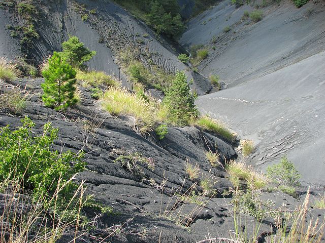
 Hiking in Aspremont
Aspremont, located in the Hautes-Alpes region of southeastern France, offers a beautiful hiking experience amidst stunning alpine landscapes. Here are some key points to consider when hiking in Aspremont:
Scenic Trails
- Diverse Terrain: The area features a range of hikes suitable for various skill levels, from easy strolls to challenging mountain routes.
- Breathtaking Views: Many trails provide expansive views of the surrounding mountains, valleys, and, on clear days, the Mediterranean in the distance.
Popular Hiking Routes
- Le Pic de Bure: A challenging hike that rewards you with panoramic views; it's suitable for experienced hikers.
- Col de la Croix: An easier option for families and beginners, offering beautiful scenery and more accessible paths.
- Local Trails: There are numerous marked trails around the village that vary in difficulty, often leading to historic sites or notable natural features.
Best Time to Hike
- Spring and Fall: These seasons provide pleasant temperatures and fewer crowds. Spring showcases blooming wildflowers, while fall offers vibrant leaf colors.
- Summer: Ideal for higher altitudes, but be prepared for more hikers and warmer temperatures.
Safety Tips
- Weather Conditions: Always check the weather forecast before heading out, as conditions can change rapidly in the mountains.
- Equipment: Wear sturdy hiking boots, and consider trekking poles for stability, especially on steep inclines. Carry enough water and snacks.
- Navigation: Some trails can be less marked, so having a map or GPS device is recommended.
Local Culture
- Wildlife: Keep an eye out for local wildlife, such as chamois and various bird species.
- Culinary Delights: After a long hike, enjoying local cuisine at nearby restaurants can be a rewarding experience.
Access
- Getting There: Aspremont is accessible by car, and there may be public transport options available depending on the season.
Hiking in Aspremont allows you to connect with nature while enjoying stunning views and the serene atmosphere of the Hautes-Alpes region. Always remember to respect the local environment and leave no trace behind. Happy hiking!
- Country:

- Postal Code: 05140
- Coordinates: 44° 29' 33" N, 5° 43' 40" E


- GPS tracks (wikiloc): [Link]
- AboveSeaLevel: 715 м m
- Area: 18.52 sq km
- Population: 341
- Wikipedia en: wiki(en)
- Wikipedia: wiki(fr)
- Wikidata storage: Wikidata: Q472337
- Wikipedia Commons Category: [Link]
- Freebase ID: [/m/03m80gs]
- Freebase ID: [/m/03m80gs]
- GeoNames ID: Alt: [6615718]
- GeoNames ID: Alt: [6615718]
- SIREN number: [210500088]
- SIREN number: [210500088]
- INSEE municipality code: 05008
- INSEE municipality code: 05008
Shares border with regions:

Sigottier
- commune in Hautes-Alpes, France
Hiking in Sigottier
Sigottier is a charming commune located in the French Alps, specifically in the Hautes-Alpes department. The area is renowned for its stunning natural landscapes, offering a variety of hiking opportunities for outdoor enthusiasts. Here are some highlights for hiking in and around Sigottier:...
- Country:
- Postal Code: 05700
- Coordinates: 44° 27' 18" N, 5° 41' 31" E
- GPS tracks (wikiloc): [Link]
- Area: 25.33 sq km
- Population: 87

Aspres-sur-Buëch
- commune in Hautes-Alpes, France
Hiking in Aspres-sur-Buëch
Aspres-sur-Buëch is a charming commune located in the Hautes-Alpes region of France, offering a range of hiking opportunities amidst stunning natural landscapes. The area is characterized by its picturesque valleys, rugged terrain, and beautiful views of the surrounding mountains. Here are some highlights for hiking around Aspres-sur-Buëch:...
- Country:
- Postal Code: 05140
- Coordinates: 44° 31' 25" N, 5° 44' 59" E
- GPS tracks (wikiloc): [Link]
- Area: 42.65 sq km
- Population: 832


Saint-Pierre-d'Argençon
- commune in Hautes-Alpes, France
Hiking in Saint-Pierre-d'Argençon
Saint-Pierre-d'Argençon is a beautiful village located in the Hautes-Alpes region of southeastern France. It is surrounded by stunning natural scenery, making it a great destination for hiking enthusiasts. Here are some details about hiking in this area:...
- Country:
- Postal Code: 05140
- Coordinates: 44° 31' 12" N, 5° 41' 54" E
- GPS tracks (wikiloc): [Link]
- Area: 18.81 sq km
- Population: 157

La Bâtie-Montsaléon
- commune in Hautes-Alpes, France
Hiking in La Bâtie-Montsaléon
La Bâtie-Montsaléon is a beautiful destination for hiking enthusiasts located in the Drôme department of France. Nestled in the stunning landscapes of the Provence-Alpes-Côte d'Azur region, it offers numerous trails that showcase the area's natural beauty, rich flora, and panoramic views of the surrounding mountains....
- Country:
- Postal Code: 05700
- Coordinates: 44° 27' 22" N, 5° 44' 58" E
- GPS tracks (wikiloc): [Link]
- Area: 15.08 sq km
- Population: 234
- Web site: [Link]

La Piarre
- commune in Hautes-Alpes, France
Hiking in La Piarre
La Piarre, located in the French Alps, is a beautiful region that offers various hiking opportunities. Here are some key highlights for those looking to explore hiking in La Piarre:...
- Country:
- Postal Code: 05700
- Coordinates: 44° 28' 31" N, 5° 39' 20" E
- GPS tracks (wikiloc): [Link]
- Area: 21.67 sq km
- Population: 90

Chabestan
- commune in Hautes-Alpes, France
Hiking in Chabestan
Chabestan, known for its breathtaking landscapes and diverse terrain, offers numerous hiking opportunities for outdoor enthusiasts of all levels. Although there may not be extensive information readily available about Chabestan, I can provide you with general tips that are applicable to hiking in areas with similar landscapes and characteristics....
- Country:
- Postal Code: 05400
- Coordinates: 44° 28' 41" N, 5° 46' 59" E
- GPS tracks (wikiloc): [Link]
- Area: 12.2 sq km
- Population: 136
- Web site: [Link]