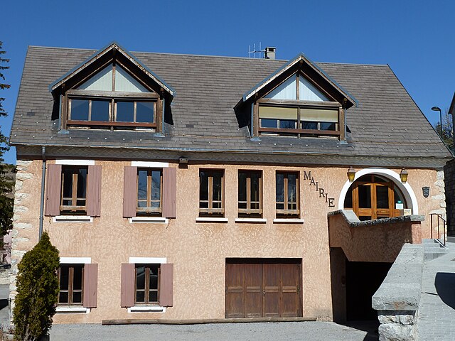
Aspres-sur-Buëch (Aspres-sur-Buëch)
- commune in Hautes-Alpes, France
 Hiking in Aspres-sur-Buëch
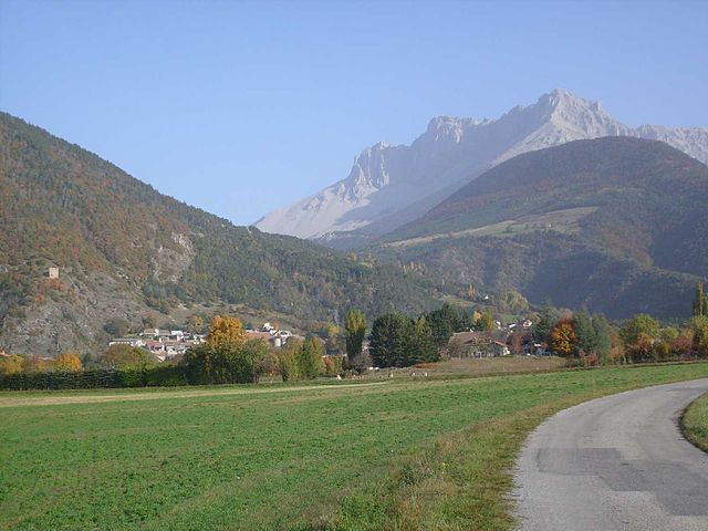
Aspres-sur-Buëch is a charming commune located in the Hautes-Alpes region of France, offering a range of hiking opportunities amidst stunning natural landscapes. The area is characterized by its picturesque valleys, rugged terrain, and beautiful views of the surrounding mountains. Here are some highlights for hiking around Aspres-sur-Buëch:
Trails and Terrain
-
Local Trails: There are various marked hiking trails suitable for different fitness levels. These trails often take you through beautiful forests, meadows, and along the Buëch River, allowing you to enjoy the region's diverse flora and fauna.
-
GR Trails: The region is part of the extensive network of Grande Randonnée (GR) trails in France, which are long-distance hiking paths. The GR94 is one such trail that passes through the area, offering challenging routes for more experienced hikers.
-
Scenic Views: Many trails in Aspres-sur-Buëch provide breathtaking views of the surrounding Alps, especially on clear days. Hikers can enjoy panoramic vistas of peaks like the Dévoluy and Oisans Massif.
Seasonality
- Spring and Summer: These seasons are ideal for hiking as the weather is generally mild, and the landscapes are green and blooming with wildflowers.
- Fall: Autumn provides beautiful foliage and cooler temperatures, perfect for those looking for a quieter hiking experience.
- Winter: While hiking is possible in winter, it's important to consider snow and ice conditions. Some trails may be closed or require snowshoes.
Preparation
- Gear: Ensure you have appropriate footwear, a good backpack, and enough water and snacks. Depending on the length of your hike, you may also want to carry additional layers for changing weather conditions.
- Maps and Guides: It's advisable to have a detailed map of the trails or a reliable GPS device. Local tourist offices can provide resources.
Safety Tips
- Stay on marked trails to protect the environment and for your own safety.
- Inform someone of your hiking plans, especially if you are going on longer or less traveled routes.
- Be prepared for sudden weather changes, especially in mountainous areas.
Local Attractions
After a day of hiking, you can explore the local culture in Aspres-sur-Buëch, sample regional cuisine, or relax in the commune's quaint atmosphere.
Overall, Aspres-sur-Buëch offers a wonderful setting for hikers looking to enjoy the beauty of the French Alps, whether you're a beginner or an experienced adventurer. Always check local conditions and regulations before heading out, and enjoy your hike!
- Country:

- Postal Code: 05140
- Coordinates: 44° 31' 25" N, 5° 44' 59" E


- GPS tracks (wikiloc): [Link]
- Area: 42.65 sq km
- Population: 832
- Wikipedia en: wiki(en)
- Wikipedia: wiki(fr)
- Wikidata storage: Wikidata: Q379985
- Wikipedia Commons Category: [Link]
- Freebase ID: [/m/03mfm6l]
- Freebase ID: [/m/03mfm6l]
- GeoNames ID: Alt: [6446620]
- GeoNames ID: Alt: [6446620]
- SIREN number: [210500104]
- SIREN number: [210500104]
- PACTOLS thesaurus ID: [pcrtR6sbwreH7k]
- PACTOLS thesaurus ID: [pcrtR6sbwreH7k]
- INSEE municipality code: 05010
- INSEE municipality code: 05010
Shares border with regions:

La Cluse
- former commune in Hautes-Alpes, France
Hiking in La Cluse
La Cluse, often referred to as La Cluse and its surrounding areas, is a beautiful destination for hikers looking for scenic views, diverse landscapes, and unique geological features. Located in the Jura region of France, it is characterized by rugged terrain, forests, and panoramic views of both mountains and valleys....
- Country:
- Postal Code: 05250
- Coordinates: 44° 38' 25" N, 5° 50' 56" E
- GPS tracks (wikiloc): [Link]
- Population: 43

Oze
- commune in Hautes-Alpes, France
Hiking in Oze
Oze National Park, located in central Japan, is a stunning destination for hiking enthusiasts. This park features a unique blend of diverse ecosystems, scenic landscapes, and rich wildlife. Here are some key points to know about hiking in Oze:...
- Country:
- Postal Code: 05400
- Coordinates: 44° 30' 18" N, 5° 48' 19" E
- GPS tracks (wikiloc): [Link]
- Area: 12.03 sq km
- Population: 109
Dévoluy
- commune in Hautes-Alpes, France
Hiking in Dévoluy
Le Dévoluy is a stunning mountain range located in the French Alps, known for its diverse landscapes, breathtaking scenery, and extensive hiking opportunities. Whether you're an experienced hiker or a beginner, there's something for everyone in this area....
- Country:
- Postal Code: 05250
- Coordinates: 44° 41' 33" N, 5° 56' 28" E
- GPS tracks (wikiloc): [Link]
- Area: 186.37 sq km
- Population: 1011
- Web site: [Link]

Veynes
- commune in Hautes-Alpes, France
Hiking in Veynes
Veynes, located in the Hautes-Alpes region of France, offers a beautiful setting for hiking enthusiasts. The area is characterized by stunning mountain scenery, varied terrain, and a network of trails suitable for different skill levels. Here are some highlights and tips for hiking in Veynes:...
- Country:
- Postal Code: 05400
- Coordinates: 44° 32' 3" N, 5° 49' 25" E
- GPS tracks (wikiloc): [Link]
- Area: 42.6 sq km
- Population: 3159
- Web site: [Link]

Aspremont
- commune in Hautes-Alpes, France
Hiking in Aspremont
Aspremont, located in the Hautes-Alpes region of southeastern France, offers a beautiful hiking experience amidst stunning alpine landscapes. Here are some key points to consider when hiking in Aspremont:...
- Country:
- Postal Code: 05140
- Coordinates: 44° 29' 33" N, 5° 43' 40" E
- GPS tracks (wikiloc): [Link]
- AboveSeaLevel: 715 м m
- Area: 18.52 sq km
- Population: 341


Saint-Pierre-d'Argençon
- commune in Hautes-Alpes, France
Hiking in Saint-Pierre-d'Argençon
Saint-Pierre-d'Argençon is a beautiful village located in the Hautes-Alpes region of southeastern France. It is surrounded by stunning natural scenery, making it a great destination for hiking enthusiasts. Here are some details about hiking in this area:...
- Country:
- Postal Code: 05140
- Coordinates: 44° 31' 12" N, 5° 41' 54" E
- GPS tracks (wikiloc): [Link]
- Area: 18.81 sq km
- Population: 157

Saint-Julien-en-Beauchêne
- commune in Hautes-Alpes, France
Hiking in Saint-Julien-en-Beauchêne
Saint-Julien-en-Beauchêne is a charming commune located in the Hautes-Alpes region of southeastern France. The area is known for its stunning natural landscapes, including mountains, forests, and picturesque valleys, making it an excellent destination for hikers of all levels....
- Country:
- Postal Code: 05140
- Coordinates: 44° 36' 58" N, 5° 42' 35" E
- GPS tracks (wikiloc): [Link]
- Area: 59.43 sq km
- Population: 124
- Web site: [Link]


La Faurie
- commune in Hautes-Alpes, France
Hiking in La Faurie
La Faurie is a picturesque village located in the Département of Hautes-Alpes in southeastern France, within the Provence-Alpes-Côte d'Azur region. The surrounding landscape offers stunning views and a variety of hiking opportunities suitable for different skill levels....
- Country:
- Postal Code: 05140
- Coordinates: 44° 34' 2" N, 5° 44' 24" E
- GPS tracks (wikiloc): [Link]
- Area: 31.44 sq km
- Population: 315
Montmaur
- commune in Hautes-Alpes, France
Hiking in Montmaur
Montmaur, located in the Hautes-Alpes department of France, offers a range of hiking opportunities for outdoor enthusiasts. Nestled in the picturesque French Alps, this area is characterized by stunning landscapes, diverse flora and fauna, and a variety of trails suitable for different skill levels....
- Country:
- Postal Code: 05400
- Coordinates: 44° 34' 16" N, 5° 52' 27" E
- GPS tracks (wikiloc): [Link]
- Area: 48.77 sq km
- Population: 515

Chabestan
- commune in Hautes-Alpes, France
Hiking in Chabestan
Chabestan, known for its breathtaking landscapes and diverse terrain, offers numerous hiking opportunities for outdoor enthusiasts of all levels. Although there may not be extensive information readily available about Chabestan, I can provide you with general tips that are applicable to hiking in areas with similar landscapes and characteristics....
- Country:
- Postal Code: 05400
- Coordinates: 44° 28' 41" N, 5° 46' 59" E
- GPS tracks (wikiloc): [Link]
- Area: 12.2 sq km
- Population: 136
- Web site: [Link]