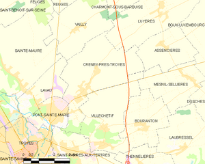
Assencières (Assencières)

- commune in Aube, France
- Country:

- Postal Code: 10220
- Coordinates: 48° 21' 31" N, 4° 11' 56" E


- GPS tracks (wikiloc): [Link]
- Area: 7.39 sq km
- Population: 175
- Wikipedia en: wiki(en)
- Wikipedia: wiki(fr)
- Wikidata storage: Wikidata: Q958037
- Wikipedia Commons Category: [Link]
- Freebase ID: [/m/03m8q6f]
- GeoNames ID: Alt: [6446909]
- SIREN number: [211000138]
- BnF ID: [15246108h]
- INSEE municipality code: 10014
Shares border with regions:


Bouy-Luxembourg
- commune in Aube, France
- Country:
- Postal Code: 10220
- Coordinates: 48° 22' 42" N, 4° 15' 26" E
- GPS tracks (wikiloc): [Link]
- Area: 12.04 sq km
- Population: 211


Mesnil-Sellières
- commune in Aube, France
- Country:
- Postal Code: 10220
- Coordinates: 48° 20' 24" N, 4° 13' 16" E
- GPS tracks (wikiloc): [Link]
- Area: 8.43 sq km
- Population: 588

Creney-près-Troyes
- commune in Aube, France
- Country:
- Postal Code: 10150
- Coordinates: 48° 19' 56" N, 4° 7' 37" E
- GPS tracks (wikiloc): [Link]
- Area: 15.76 sq km
- Population: 1783

Rouilly-Sacey
- commune in Aube, France
- Country:
- Postal Code: 10220
- Coordinates: 48° 20' 46" N, 4° 15' 45" E
- GPS tracks (wikiloc): [Link]
- Area: 19.48 sq km
- Population: 387

Villechétif
- commune in Aube, France
- Country:
- Postal Code: 10410
- Coordinates: 48° 18' 41" N, 4° 8' 42" E
- GPS tracks (wikiloc): [Link]
- Area: 12.24 sq km
- Population: 921


Luyères
- commune in Aube, France
- Country:
- Postal Code: 10150
- Coordinates: 48° 22' 56" N, 4° 11' 42" E
- GPS tracks (wikiloc): [Link]
- AboveSeaLevel: 150 м m
- Area: 17.37 sq km
- Population: 453