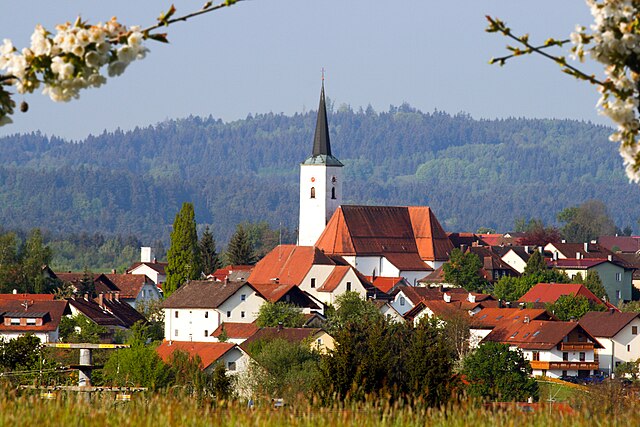
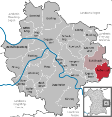
Außernzell (Außernzell)
- municipality of Germany
Außernzell is a picturesque area located in Bavaria, Germany, known for its beautiful landscapes, rolling hills, and lush greenery. Hiking in this region can be quite rewarding for both beginners and experienced hikers. Here are some highlights and tips for hiking in Außernzell:
Hiking Trails
-
Local Trails: Außernzell offers a network of well-marked hiking trails that range in difficulty. The trails often lead through forests, fields, and along rivers, providing a diverse hiking experience.
-
Scenic Views: Many trails offer stunning vistas of the Bavarian countryside, particularly in the clearer months when you can enjoy views of the surrounding mountains and valleys.
-
Nature and Wildlife: While hiking, keep an eye out for local wildlife. The area is home to various bird species and other fauna, perfect for nature enthusiasts.
Recommendations
-
Start with Easy Trails: If you are new to hiking, consider starting on one of the easier trails before moving on to more challenging routes.
-
Local Guides: Consider joining a guided hike if you want to learn more about the area’s history and ecology. Local guides can provide valuable insights and enhance your experience.
-
Weather Considerations: Check the weather before setting out, as conditions can change quickly. Always dress in layers and wear sturdy hiking shoes.
-
Carry Essentials: Always bring enough water, snacks, a basic first-aid kit, and a map or GPS device to help navigate the trails.
Nearby Attractions
-
Cultural Sites: The region is home to several small villages and churches that reflect Bavarian culture and history, adding a cultural aspect to your hiking adventure.
-
Seasonal Hiking: Depending on the season, you may encounter different flora and fauna, making each hike unique. Spring and summer are ideal for wildflowers, while autumn offers beautiful foliage.
Overall, hiking in Außernzell can be a serene and enjoyable experience, allowing you to immerse yourself in nature while exploring the scenic beauty of Bavaria. Be sure to follow local guidelines and respect nature during your hikes!
- Country:

- Postal Code: 94532
- Local Dialing Code: 08544; 09903
- Licence Plate Code: DEG
- Coordinates: 48° 43' 0" N, 13° 12' 0" E


- GPS tracks (wikiloc): [Link]
- AboveSeaLevel: 372 м m
- Area: 24.11 sq km
- Population: 1377
- Web site: https://www.aussernzell.info/
- Wikipedia en: wiki(en)
- Wikipedia: wiki(de)
- Wikidata storage: Wikidata: Q306451
- Wikipedia Commons Category: [Link]
- Freebase ID: [/m/02q0_rk]
- GeoNames ID: Alt: [2953932]
- VIAF ID: Alt: [136722609]
- OSM relation ID: [959813]
- GND ID: Alt: [4519632-1]
- Historical Gazetteer (GOV) ID: [AUSELLJN68OR]
- Bavarikon ID: [ODB_A00001434]
- German municipality key: 09271114
Shares border with regions:


Zenting
- municipality of Germany
Zenting, located in Bavaria, Germany, is surrounded by beautiful landscapes perfect for hiking enthusiasts. Here are some details to consider when planning your hikes in the Zenting area:...
- Country:

- Postal Code: 94579
- Local Dialing Code: 09907
- Licence Plate Code: FRG
- Coordinates: 48° 48' 0" N, 13° 16' 0" E


- GPS tracks (wikiloc): [Link]
- AboveSeaLevel: 450 м m
- Area: 22.26 sq km
- Population: 1170
- Web site: [Link]


Eging am See
- municipality of Germany
Eging am See, located in Bavaria, Germany, is a charming destination for outdoor enthusiasts, particularly those interested in hiking. The area is known for its scenic landscapes, including the beautiful Egginger See (Eging Lake), lush forests, and rolling hills. Here are some highlights and tips for hiking in Eging am See:...
- Country:

- Postal Code: 94535
- Local Dialing Code: 08544
- Licence Plate Code: PA
- Coordinates: 48° 43' 0" N, 13° 16' 0" E


- GPS tracks (wikiloc): [Link]
- AboveSeaLevel: 399 м m
- Area: 23.66 sq km
- Population: 3208
- Web site: [Link]


Iggensbach
- municipality of Germany
Iggensbach is a beautiful village located in Bavaria, Germany, known for its picturesque landscapes and outdoor recreational opportunities, including hiking. Here's a brief overview of what you can expect when hiking in and around Iggensbach:...
- Country:

- Postal Code: 94547
- Local Dialing Code: 09903
- Licence Plate Code: DEG
- Coordinates: 48° 44' 0" N, 13° 8' 0" E


- GPS tracks (wikiloc): [Link]
- AboveSeaLevel: 382 м m
- Area: 19.08 sq km
- Population: 2014
- Web site: [Link]


Thurmansbang
- municipality of Germany
Thurmansbang is a picturesque village located in Bavaria, Germany, surrounded by the beautiful landscape of the Bavarian Forest. It's an excellent destination for hiking enthusiasts, offering a variety of trails that cater to different skill levels and preferences....
- Country:

- Postal Code: 94169
- Local Dialing Code: 08504
- Licence Plate Code: FRG
- Coordinates: 48° 46' 0" N, 13° 19' 0" E


- GPS tracks (wikiloc): [Link]
- AboveSeaLevel: 494 м m
- Area: 32.93 sq km
- Population: 2159
- Web site: [Link]


Schöllnach
- municipality of Germany
Schöllnach is a beautiful region located in Bavaria, Germany, known for its lush landscapes and scenic hiking trails. Nestled in the heart of the Bavarian Forest, it offers a variety of hiking opportunities suitable for all levels, from beginners to experienced hikers....
- Country:

- Postal Code: 94508
- Local Dialing Code: 09903
- Licence Plate Code: DEG
- Coordinates: 48° 45' 0" N, 13° 10' 0" E


- GPS tracks (wikiloc): [Link]
- AboveSeaLevel: 371 м m
- Area: 39.9 sq km
- Population: 4772
- Web site: [Link]

