Aubin (Aubin)

- commune in Aveyron, France
- Country:

- Postal Code: 12110
- Coordinates: 44° 31' 40" N, 2° 14' 45" E


- GPS tracks (wikiloc): [Link]
- Area: 27.23 sq km
- Population: 3834
- Wikipedia en: wiki(en)
- Wikipedia: wiki(fr)
- Wikidata storage: Wikidata: Q990646
- Wikipedia Commons Category: [Link]
- Freebase ID: [/m/03m92p4]
- GeoNames ID: Alt: [6454955]
- SIREN number: [211200134]
- BnF ID: [15246989j]
- INSEE municipality code: 12013
Shares border with regions:

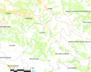
Auzits
- commune in Aveyron, France
- Country:
- Postal Code: 12390
- Coordinates: 44° 30' 25" N, 2° 19' 40" E
- GPS tracks (wikiloc): [Link]
- Area: 24.34 sq km
- Population: 860
- Web site: [Link]

Firmi
- commune in Aveyron, France
- Country:
- Postal Code: 12300
- Coordinates: 44° 32' 24" N, 2° 18' 39" E
- GPS tracks (wikiloc): [Link]
- Area: 29.13 sq km
- Population: 2430


Galgan
- commune in Aveyron, France
- Country:
- Postal Code: 12220
- Coordinates: 44° 30' 10" N, 2° 10' 44" E
- GPS tracks (wikiloc): [Link]
- Area: 20.37 sq km
- Population: 359


Valzergues
- commune in Aveyron, France
- Country:
- Postal Code: 12220
- Coordinates: 44° 29' 57" N, 2° 13' 17" E
- GPS tracks (wikiloc): [Link]
- Area: 6.49 sq km
- Population: 217


Viviez
- commune in Aveyron, France
- Country:
- Postal Code: 12110
- Coordinates: 44° 33' 23" N, 2° 12' 57" E
- GPS tracks (wikiloc): [Link]
- Area: 6.53 sq km
- Population: 1276
- Web site: [Link]

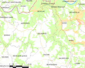
Les Albres
- commune in Aveyron, France
- Country:
- Postal Code: 12220
- Coordinates: 44° 32' 16" N, 2° 10' 25" E
- GPS tracks (wikiloc): [Link]
- Area: 15.22 sq km
- Population: 343


Cransac
- commune in Aveyron, France
- Country:
- Postal Code: 12110
- Coordinates: 44° 31' 30" N, 2° 17' 5" E
- GPS tracks (wikiloc): [Link]
- Area: 6.91 sq km
- Population: 1537
- Web site: [Link]
Decazeville
- commune in Aveyron, France
- Country:
- Postal Code: 12300
- Coordinates: 44° 33' 33" N, 2° 15' 20" E
- GPS tracks (wikiloc): [Link]
- Area: 13.88 sq km
- Population: 5521
- Web site: [Link]


Lugan
- commune in Aveyron, France
- Country:
- Postal Code: 12220
- Coordinates: 44° 28' 58" N, 2° 15' 32" E
- GPS tracks (wikiloc): [Link]
- AboveSeaLevel: 500 м m
- Area: 12.61 sq km
- Population: 339