Auvet-et-la-Chapelotte (Auvet-et-la-Chapelotte)

- commune in Haute-Saône, France
- Country:

- Postal Code: 70100
- Coordinates: 47° 30' 33" N, 5° 31' 2" E


- GPS tracks (wikiloc): [Link]
- Area: 14.43 sq km
- Population: 247
- Wikipedia en: wiki(en)
- Wikipedia: wiki(fr)
- Wikidata storage: Wikidata: Q789556
- Wikipedia Commons Category: [Link]
- Freebase ID: [/m/03nt184]
- GeoNames ID: Alt: [6450800]
- SIREN number: [217000439]
- BnF ID: [15272437k]
- PACTOLS thesaurus ID: [pcrtN6jf94QyEs]
- INSEE municipality code: 70043
Shares border with regions:

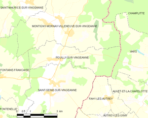
Pouilly-sur-Vingeanne
- commune in Côte-d'Or, France
- Country:
- Postal Code: 21610
- Coordinates: 47° 32' 24" N, 5° 25' 55" E
- GPS tracks (wikiloc): [Link]
- Area: 10.56 sq km
- Population: 116

Autrey-lès-Gray
- commune in Haute-Saône, France
- Country:
- Postal Code: 70100
- Coordinates: 47° 29' 11" N, 5° 29' 27" E
- GPS tracks (wikiloc): [Link]
- Area: 32.4 sq km
- Population: 380
Bouhans-et-Feurg
- commune in Haute-Saône, France
- Country:
- Postal Code: 70100
- Coordinates: 47° 28' 42" N, 5° 30' 25" E
- GPS tracks (wikiloc): [Link]
- Area: 9.75 sq km
- Population: 253
Chargey-lès-Gray
- commune in Haute-Saône, France
- Country:
- Postal Code: 70100
- Coordinates: 47° 29' 15" N, 5° 34' 31" E
- GPS tracks (wikiloc): [Link]
- Area: 16.56 sq km
- Population: 726
Fahy-lès-Autrey
- commune in Haute-Saône, France
- Country:
- Postal Code: 70100
- Coordinates: 47° 30' 46" N, 5° 28' 54" E
- GPS tracks (wikiloc): [Link]
- Area: 6.2 sq km
- Population: 116


Oyrières
- commune in Haute-Saône, France
- Country:
- Postal Code: 70600
- Coordinates: 47° 31' 58" N, 5° 33' 49" E
- GPS tracks (wikiloc): [Link]
- Area: 14.03 sq km
- Population: 390


Vars
- commune in Haute-Saône, France
- Country:
- Postal Code: 70600
- Coordinates: 47° 32' 2" N, 5° 32' 0" E
- GPS tracks (wikiloc): [Link]
- Area: 16.16 sq km
- Population: 199