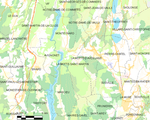
Avignonet (Avignonet)

- commune in Isère, France
 Hiking in Avignonet
Avignonet is a charming locality that offers beautiful hiking opportunities, especially for those who appreciate scenic landscapes and historical surroundings. Here are some key highlights about hiking in and around Avignonet:
-
Scenic Trails: The region boasts various trails ranging from easy strolls to more challenging hikes. Many paths weave through vineyards, olive groves, and rolling hills, providing stunning views of the countryside.
-
Historical Sites: As you hike, you'll likely encounter historical landmarks, such as old churches or ruins, which add a cultural element to your adventure. Exploring these sites provides context about the area’s history and heritage.
-
Nature and Wildlife: The diverse ecosystems around Avignonet make it a great spot for nature enthusiasts. Depending on the time of year, you may see a variety of wildflowers and local fauna, enhancing your hiking experience.
-
Guided Tours: If you’re new to the area or prefer a structured experience, consider joining a guided hiking tour. Local guides can provide valuable insights into the geography, history, and ecology of the region.
-
Preparation: Ensure you wear appropriate hiking gear, including sturdy boots and weather-appropriate clothing. Carry plenty of water, snacks, and a map (or a GPS device) to stay oriented.
-
Respect Nature: When hiking, be mindful of local wildlife and follow Leave No Trace principles to help preserve the natural beauty of Avignonet for future hikers.
Whether you're looking for a leisurely walk or a more strenuous hike, the area around Avignonet offers a wonderful blend of nature, history, and culture. Enjoy your adventure!
- Country:

- Postal Code: 38650
- Coordinates: 44° 57' 32" N, 5° 39' 25" E


- GPS tracks (wikiloc): [Link]
- Area: 8.41 sq km
- Population: 189
- Web site: http://commune-avignonet.fr
- Wikipedia en: wiki(en)
- Wikipedia: wiki(fr)
- Wikidata storage: Wikidata: Q1069612
- Wikipedia Commons Category: [Link]
- Freebase ID: [/m/03g_7h_]
- GeoNames ID: Alt: [6448719]
- SIREN number: [213800238]
- BnF ID: [15257852c]
- INSEE municipality code: 38023
Shares border with regions:


Monteynard
- commune in Isère, France
Hiking in Monteynard
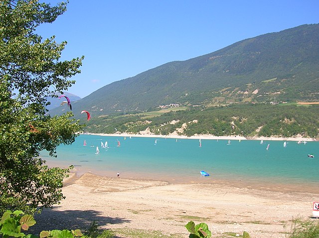
Monteynard, located in the Isère department of southeastern France, is known for its stunning landscapes, particularly the beautiful turquoise waters of the Lake Monteynard-Avignonet and the surrounding mountainous terrain. Hiking in this area offers a variety of trails that cater to different skill levels, providing opportunities for both leisurely strolls and more challenging hikes....
- Country:
- Postal Code: 38770
- Coordinates: 44° 58' 33" N, 5° 42' 18" E
- GPS tracks (wikiloc): [Link]
- Area: 10.72 sq km
- Population: 498
- Web site: [Link]

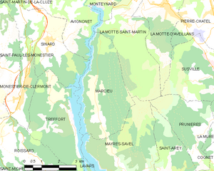
La Motte-Saint-Martin
- commune in Isère, France
Hiking in La Motte-Saint-Martin
La Motte-Saint-Martin is a charming village located in the Vosges department in northeastern France, surrounded by beautiful natural landscapes that are perfect for hiking enthusiasts. The area is characterized by its rolling hills, lush forests, and scenic views, making it an excellent destination for outdoor activities. Here are some highlights of hiking in and around La Motte-Saint-Martin:...
- Country:
- Postal Code: 38770
- Coordinates: 44° 57' 1" N, 5° 43' 4" E
- GPS tracks (wikiloc): [Link]
- Area: 14.64 sq km
- Population: 432
- Web site: [Link]


Saint-Martin-de-la-Cluze
- commune in Isère, France
Hiking in Saint-Martin-de-la-Cluze
Saint-Martin-de-la-Cluze is a picturesque village located in the French Alps, specifically in the Isère department. Its stunning natural scenery and diverse topography make it a fantastic destination for hiking enthusiasts....
- Country:
- Postal Code: 38650
- Coordinates: 44° 58' 58" N, 5° 39' 31" E
- GPS tracks (wikiloc): [Link]
- AboveSeaLevel: 760 м m
- Area: 16.26 sq km
- Population: 705
- Web site: [Link]
Marcieu
- commune in Isère, France
Hiking in Marcieu
Marcieu is a charming village located in the French Alps, within the Isère department. It’s part of the Chartreuse Regional Natural Park, renowned for its stunning landscapes, diverse wildlife, and rich flora. Hiking in Marcieu offers a variety of trails suitable for different skill levels, making it a great destination for both casual walkers and experienced hikers....
- Country:
- Postal Code: 38350
- Coordinates: 44° 54' 53" N, 5° 41' 23" E
- GPS tracks (wikiloc): [Link]
- Area: 11.97 sq km
- Population: 75
- Web site: [Link]


Sinard
- commune in Isère, France
Hiking in Sinard
Sinard is a beautiful area that offers various hiking opportunities, though it’s less widely known compared to some other hiking destinations. The region is characterized by stunning landscapes, including mountains, forests, and possibly bodies of water, making it an excellent choice for nature enthusiasts....
- Country:
- Postal Code: 38650
- Coordinates: 44° 56' 44" N, 5° 39' 25" E
- GPS tracks (wikiloc): [Link]
- Area: 10.44 sq km
- Population: 662