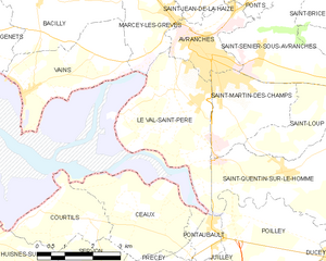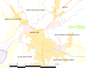
Avranches (Avranches)
- commune in Manche, France
- Country:

- Postal Code: 50300
- Coordinates: 48° 41' 4" N, 1° 21' 25" E


- GPS tracks (wikiloc): [Link]
- Area: 4.5 sq km
- Population: 7766
- Web site: http://www.avranches.fr
- Wikipedia en: wiki(en)
- Wikipedia: wiki(fr)
- Wikidata storage: Wikidata: Q204430
- Wikipedia Commons Category: [Link]
- Freebase ID: [/m/02hczr]
- Freebase ID: [/m/02hczr]
- GeoNames ID: Alt: [3035639]
- GeoNames ID: Alt: [3035639]
- SIREN number: [215000258]
- SIREN number: [215000258]
- BnF ID: [152620049]
- BnF ID: [152620049]
- VIAF ID: Alt: [132643376]
- VIAF ID: Alt: [132643376]
- OSM relation ID: [416063]
- OSM relation ID: [416063]
- GND ID: Alt: [4079897-5]
- GND ID: Alt: [4079897-5]
- PACTOLS thesaurus ID: [pcrtLufMdlgyKG]
- PACTOLS thesaurus ID: [pcrtLufMdlgyKG]
- MusicBrainz area ID: [1890159a-0667-453c-8f92-55531d7a7e44]
- MusicBrainz area ID: [1890159a-0667-453c-8f92-55531d7a7e44]
- Quora topic ID: [Avranches]
- Quora topic ID: [Avranches]
- EMLO location ID: [5a48bbde-1a34-4843-bb47-cd96a7cd27f6]
- EMLO location ID: [5a48bbde-1a34-4843-bb47-cd96a7cd27f6]
- Digital Atlas of the Roman Empire ID: [133]
- Digital Atlas of the Roman Empire ID: [133]
- NKCR AUT ID: [ge887069]
- NKCR AUT ID: [ge887069]
- INSEE municipality code: 50025
- INSEE municipality code: 50025
Shares border with regions:


Saint-Jean-de-la-Haize
- commune in Manche, France
- Country:

- Postal Code: 50300
- Coordinates: 48° 42' 15" N, 1° 21' 39" E


- GPS tracks (wikiloc): [Link]
- Area: 8.95 sq km
- Population: 499


Ponts
- commune in Manche, France
- Country:

- Postal Code: 50300
- Coordinates: 48° 42' 12" N, 1° 20' 42" E


- GPS tracks (wikiloc): [Link]
- Area: 6.7 sq km
- Population: 615
- Web site: [Link]


Saint-Senier-sous-Avranches
- commune in Manche, France
- Country:

- Postal Code: 50300
- Coordinates: 48° 41' 4" N, 1° 20' 30" E


- GPS tracks (wikiloc): [Link]
- Area: 8.62 sq km
- Population: 1377


Saint-Martin-des-Champs
- commune in Manche, France
- Country:

- Postal Code: 50300
- Coordinates: 48° 40' 10" N, 1° 19' 52" E


- GPS tracks (wikiloc): [Link]
- Area: 6.49 sq km
- Population: 2327


Le Val-Saint-Père
- commune in Manche, France
- Country:

- Postal Code: 50300
- Coordinates: 48° 39' 48" N, 1° 22' 30" E


- GPS tracks (wikiloc): [Link]
- Area: 11.1 sq km
- Population: 2017
- Web site: [Link]


Marcey-les-Grèves
- commune in Manche, France
- Country:

- Postal Code: 50300
- Coordinates: 48° 41' 48" N, 1° 23' 29" E


- GPS tracks (wikiloc): [Link]
- Area: 6.73 sq km
- Population: 1270
