Saint-Martin-des-Champs (Saint-Martin-des-Champs)

- commune in Manche, France
- Country:

- Postal Code: 50300
- Coordinates: 48° 40' 10" N, 1° 19' 52" E


- GPS tracks (wikiloc): [Link]
- Area: 6.49 sq km
- Population: 2327
- Wikipedia en: wiki(en)
- Wikipedia: wiki(fr)
- Wikidata storage: Wikidata: Q581232
- Wikipedia Commons Category: [Link]
- Freebase ID: [/m/03qf731]
- Freebase ID: [/m/03qf731]
- GeoNames ID: Alt: [6435619]
- GeoNames ID: Alt: [6435619]
- SIREN number: [215005166]
- SIREN number: [215005166]
- BnF ID: [15262489m]
- BnF ID: [15262489m]
- INSEE municipality code: 50516
- INSEE municipality code: 50516
Shares border with regions:

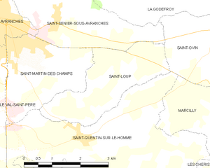
Saint-Loup
- commune in Manche, France
- Country:
- Postal Code: 50300
- Coordinates: 48° 40' 4" N, 1° 17' 42" E
- GPS tracks (wikiloc): [Link]
- Area: 6.45 sq km
- Population: 716

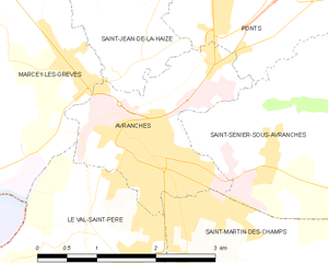
Avranches
- commune in Manche, France
- Country:
- Postal Code: 50300
- Coordinates: 48° 41' 4" N, 1° 21' 25" E
- GPS tracks (wikiloc): [Link]
- Area: 4.5 sq km
- Population: 7766
- Web site: [Link]


Saint-Quentin-sur-le-Homme
- commune in Manche, France
- Country:
- Postal Code: 50220
- Coordinates: 48° 38' 51" N, 1° 19' 0" E
- GPS tracks (wikiloc): [Link]
- Area: 16.84 sq km
- Population: 1219
- Web site: [Link]


Saint-Senier-sous-Avranches
- commune in Manche, France
- Country:
- Postal Code: 50300
- Coordinates: 48° 41' 4" N, 1° 20' 30" E
- GPS tracks (wikiloc): [Link]
- Area: 8.62 sq km
- Population: 1377

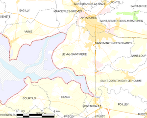
Le Val-Saint-Père
- commune in Manche, France
- Country:
- Postal Code: 50300
- Coordinates: 48° 39' 48" N, 1° 22' 30" E
- GPS tracks (wikiloc): [Link]
- Area: 11.1 sq km
- Population: 2017
- Web site: [Link]