Ayguetinte (Ayguetinte)

- commune in Gers, France
- Country:

- Postal Code: 32410
- Coordinates: 43° 50' 3" N, 0° 25' 38" E


- GPS tracks (wikiloc): [Link]
- AboveSeaLevel: 113 м m
- Area: 6.31 sq km
- Population: 162
- Wikipedia en: wiki(en)
- Wikipedia: wiki(fr)
- Wikidata storage: Wikidata: Q997031
- Wikipedia Commons Category: [Link]
- Freebase ID: [/m/03cfpmj]
- GeoNames ID: Alt: [6616500]
- SIREN number: [213200249]
- BnF ID: [15255611r]
- INSEE municipality code: 32024
Shares border with regions:
Larroque-Saint-Sernin
- commune in Gers, France
- Country:
- Postal Code: 32410
- Coordinates: 43° 49' 31" N, 0° 27' 55" E
- GPS tracks (wikiloc): [Link]
- Area: 17.96 sq km
- Population: 168


Castéra-Verduzan
- commune in Gers, France
- Country:
- Postal Code: 32410
- Coordinates: 43° 48' 16" N, 0° 25' 50" E
- GPS tracks (wikiloc): [Link]
- Area: 19.82 sq km
- Population: 990
- Web site: [Link]


Valence-sur-Baïse
- commune in Gers, France
- Country:
- Postal Code: 32310
- Coordinates: 43° 52' 56" N, 0° 22' 53" E
- GPS tracks (wikiloc): [Link]
- Area: 27.6 sq km
- Population: 1131
- Web site: [Link]


Beaucaire
- commune in Gers, France
- Country:
- Postal Code: 32410
- Coordinates: 43° 50' 15" N, 0° 23' 5" E
- GPS tracks (wikiloc): [Link]
- Area: 16.14 sq km
- Population: 277

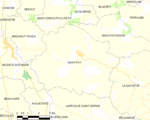
Saint-Puy
- commune in Gers, France
- Country:
- Postal Code: 32310
- Coordinates: 43° 52' 35" N, 0° 27' 44" E
- GPS tracks (wikiloc): [Link]
- Area: 36.88 sq km
- Population: 592
- Web site: [Link]