Bélesta (Bélesta)
- commune in Ariège, France
- Country:

- Postal Code: 09300
- Coordinates: 42° 54' 13" N, 1° 56' 4" E


- GPS tracks (wikiloc): [Link]
- Area: 26.94 sq km
- Population: 1029
- Wikipedia en: wiki(en)
- Wikipedia: wiki(fr)
- Wikidata storage: Wikidata: Q629760
- Wikipedia Commons Category: [Link]
- Freebase ID: [/m/03m8lk6]
- GeoNames ID: Alt: [6454942]
- SIREN number: [210900478]
- OSM relation ID: [1776127]
- INSEE municipality code: 09047
Shares border with regions:


Rivel
- commune in Aude, France
- Country:
- Postal Code: 11230
- Coordinates: 42° 56' 40" N, 2° 0' 1" E
- GPS tracks (wikiloc): [Link]
- Area: 24.3 sq km
- Population: 196

Fougax-et-Barrineuf
- commune in Ariège, France
- Country:
- Postal Code: 09300
- Coordinates: 42° 52' 48" N, 1° 53' 33" E
- GPS tracks (wikiloc): [Link]
- Area: 31.48 sq km
- Population: 439

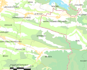
Lesparrou
- commune in Ariège, France
- Country:
- Postal Code: 09300
- Coordinates: 42° 55' 50" N, 1° 54' 16" E
- GPS tracks (wikiloc): [Link]
- Area: 16.09 sq km
- Population: 231


Belcaire
- commune in Aude, France
- Country:
- Postal Code: 11340
- Coordinates: 42° 48' 57" N, 1° 57' 26" E
- GPS tracks (wikiloc): [Link]
- Area: 30.68 sq km
- Population: 393
- Web site: [Link]


Roquefeuil
- commune in Aude, France
- Country:
- Postal Code: 11340
- Coordinates: 42° 49' 13" N, 1° 59' 42" E
- GPS tracks (wikiloc): [Link]
- Area: 22.38 sq km
- Population: 284

L'Aiguillon
- commune in Ariège, France
- Country:
- Postal Code: 09300
- Coordinates: 42° 55' 2" N, 1° 54' 4" E
- GPS tracks (wikiloc): [Link]
- Area: 6.37 sq km
- Population: 420