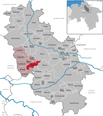
Bülstedt (Bülstedt)
- municipality of Germany
Bülstedt, a small village in Lower Saxony, Germany, is surrounded by beautiful countryside and offers a variety of hiking opportunities. While it may not be as well-known as larger hiking regions, it provides a peaceful escape into nature for those looking to explore the area.
Hiking Trails
-
Local Trails: There are several local trails that meander through forests, fields, and along rivers. These trails often provide a chance to see local flora and fauna and enjoy the tranquility of the rural landscape.
-
Nature Reserves: Look for trails that lead into nearby nature reserves, which can provide stunning views and a diverse range of ecosystems. Walking here allows you to observe wildlife and engage with nature.
-
Cultural Routes: Some paths may also take you through historic sites or farms that represent the local culture and heritage.
Preparation Tips
- Maps and Guides: Make sure to have a local map or a hiking app for navigation as well-marked trails can vary in accessibility.
- Weather Checks: The weather can be changeable, so check forecasts before heading out, and dress in layers.
- Footwear: Good hiking boots are recommended to navigate uneven terrain comfortably.
Accessibility
Bülstedt is well-connected, and many trails start from the village or can be accessed with a short drive. It's best to think about the length and difficulty level of hikes that suit your group.
Local Amenities
After a hike, you might want to enjoy some local cuisine. Look for nearby restaurants or cafés where you can relax and refuel.
Summary
Hiking in Bülstedt offers a lovely blend of nature and tranquility, perfect for those looking to escape the hustle and bustle of city life. Whether you are a seasoned hiker or a novice, the area holds a welcoming atmosphere for all outdoor enthusiasts. Enjoy your exploration!
- Country:

- Postal Code: 27412
- Local Dialing Code: 04288; 04283
- Licence Plate Code: ROW
- Coordinates: 53° 12' 33" N, 9° 9' 39" E


- GPS tracks (wikiloc): [Link]
- AboveSeaLevel: 25 м m
- Area: 25.53 sq km
- Population: 748
- Web site: http://www.tarmstedt.de/
- Wikipedia en: wiki(en)
- Wikipedia: wiki(de)
- Wikidata storage: Wikidata: Q514936
- Wikipedia Commons Category: [Link]
- Freebase ID: [/m/02rzw3k]
- Freebase ID: [/m/02rzw3k]
- Freebase ID: [/m/02rzw3k]
- GeoNames ID: Alt: [2941747]
- GeoNames ID: Alt: [2941747]
- GeoNames ID: Alt: [2941747]
- VIAF ID: Alt: [143218405]
- VIAF ID: Alt: [143218405]
- VIAF ID: Alt: [143218405]
- OSM relation ID: [965607]
- OSM relation ID: [965607]
- OSM relation ID: [965607]
- GND ID: Alt: [4278684-8]
- GND ID: Alt: [4278684-8]
- GND ID: Alt: [4278684-8]
- Library of Congress authority ID: Alt: [n93098499]
- Library of Congress authority ID: Alt: [n93098499]
- Library of Congress authority ID: Alt: [n93098499]
- Historical Gazetteer (GOV) ID: [BULEDT_W2733]
- Historical Gazetteer (GOV) ID: [BULEDT_W2733]
- Historical Gazetteer (GOV) ID: [BULEDT_W2733]
- German municipality key: 03357010
- German municipality key: 03357010
- German municipality key: 03357010

