Bacilly (Bacilly)

- commune in Manche, France
- Country:

- Postal Code: 50530
- Coordinates: 48° 42' 4" N, 1° 26' 27" E


- GPS tracks (wikiloc): [Link]
- Area: 15.88 sq km
- Population: 929
- Web site: http://www.ville-bacilly.com
- Wikipedia en: wiki(en)
- Wikipedia: wiki(fr)
- Wikidata storage: Wikidata: Q531895
- Wikipedia Commons Category: [Link]
- Freebase ID: [/m/03qcp_5]
- Freebase ID: [/m/03qcp_5]
- GeoNames ID: Alt: [6449458]
- GeoNames ID: Alt: [6449458]
- SIREN number: [215000274]
- SIREN number: [215000274]
- BnF ID: [152620060]
- BnF ID: [152620060]
- INSEE municipality code: 50027
- INSEE municipality code: 50027
Shares border with regions:


Dragey-Ronthon
- commune in Manche, France
- Country:
- Postal Code: 50530
- Coordinates: 48° 43' 0" N, 1° 30' 0" E
- GPS tracks (wikiloc): [Link]
- AboveSeaLevel: 40 м m
- Area: 15.17 sq km
- Population: 817
- Web site: [Link]

Genêts
- commune in Manche, France
- Country:
- Postal Code: 50530
- Coordinates: 48° 41' 3" N, 1° 28' 36" E
- GPS tracks (wikiloc): [Link]
- Area: 6.89 sq km
- Population: 431
- Web site: [Link]


Vains
- commune in Manche, France
- Country:
- Postal Code: 50300
- Coordinates: 48° 40' 54" N, 1° 24' 44" E
- GPS tracks (wikiloc): [Link]
- Area: 8.58 sq km
- Population: 741
- Web site: [Link]


Marcey-les-Grèves
- commune in Manche, France
- Country:
- Postal Code: 50300
- Coordinates: 48° 41' 48" N, 1° 23' 29" E
- GPS tracks (wikiloc): [Link]
- Area: 6.73 sq km
- Population: 1270

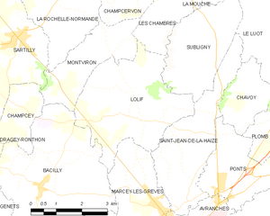
Lolif
- commune in Manche, France
- Country:
- Postal Code: 50530
- Coordinates: 48° 44' 2" N, 1° 23' 35" E
- GPS tracks (wikiloc): [Link]
- Area: 12.5 sq km
- Population: 559
- Web site: [Link]