Bad Gottleuba-Berggießhübel (Bad Gottleuba-Berggießhübel)

- town in the Free State of Saxony, Germany
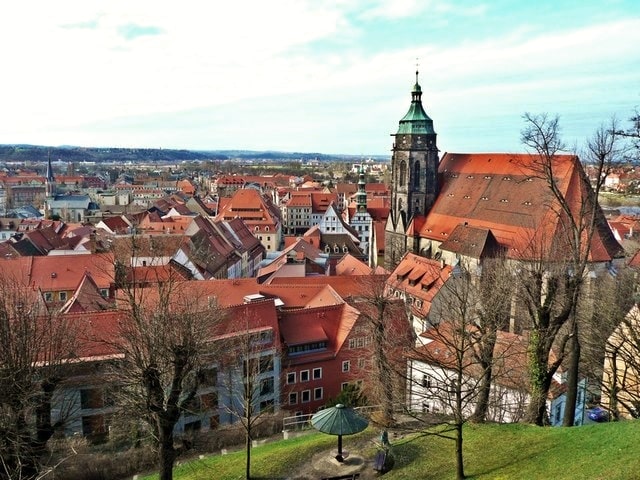
 Hiking in Bad Gottleuba-Berggießhübel
Bad Gottleuba-Berggießhübel is a picturesque region located in the Saxon Switzerland area of Germany, known for its stunning landscapes, rich natural beauty, and a variety of hiking opportunities. Here are some key points to consider if you plan to hike in this area:
Hiking Trails:
-
Talwanderweg: This is a relatively easy, family-friendly path that meanders through the beautiful valleys. It provides plenty of opportunities to enjoy the surrounding nature and is suitable for all skill levels.
-
Saxon Switzerland National Park: While not directly in Bad Gottleuba-Berggießhübel, the park is nearby and offers numerous trails. The trails here can range from easy walks to challenging climbs, including famous routes leading to rock formations like the Bastei.
-
Panorama Trails: Look for trails that offer breathtaking views of the Elbe River and surrounding valleys. The forest trails in the area are particularly inviting in spring and autumn when the foliage changes colors.
Scenic Highlights:
- Rocks and Cliffs: The region features fascinating rock formations typical of the Saxon Switzerland area, perfect for photography and nature appreciation.
- Historical Landmarks: You may come across ruins and historical sites along the trails, which can make your hike even more enriching.
Preparation:
- Weather Conditions: Be aware of the weather before you head out, as conditions can change quickly in mountainous areas.
- Gear: Wear appropriate hiking boots and carry enough water and snacks. A map or GPS device can also be very helpful for navigation.
- Difficulty Levels: Assess your own fitness and skill level to choose suitable trails. Some routes may have steep ascents or more rigorous terrain.
Safety:
- Always inform someone of your hiking plans and expected return time, especially if you are hiking alone.
- Be cautious of wildlife and other natural hazards while on the trail.
Overall, hiking in Bad Gottleuba-Berggießhübel offers a wonderful blend of natural beauty, adventure, and tranquility, making it an excellent choice for hikers of all levels. Enjoy your hiking experience!
- Country:

- Postal Code: 01816
- Local Dialing Code: 035054; 035032; 035025; 035023
- Licence Plate Code: PIR
- Coordinates: 50° 51' 30" N, 13° 57' 0" E


- GPS tracks (wikiloc): [Link]
- AboveSeaLevel: 364 м m
- Area: 88.75 sq km
- Population: 5624
- Web site: http://www.stadt-badgottleuba-berggiesshuebel.de/
- Wikipedia en: wiki(en)
- Wikipedia: wiki(de)
- Wikidata storage: Wikidata: Q6307
- Wikipedia Commons Gallery: [Link]
- Wikipedia Commons Category: [Link]
- Freebase ID: [/m/04hv24]
- Freebase ID: [/m/04hv24]
- GeoNames ID: Alt: [6550816]
- GeoNames ID: Alt: [6550816]
- VIAF ID: Alt: [247846782]
- VIAF ID: Alt: [247846782]
- OSM relation ID: [534518]
- OSM relation ID: [534518]
- GND ID: Alt: [4710075-8]
- GND ID: Alt: [4710075-8]
- MusicBrainz area ID: [8dd1c6f8-b1f3-4c3e-8c59-87965cc3314f]
- MusicBrainz area ID: [8dd1c6f8-b1f3-4c3e-8c59-87965cc3314f]
- Historical Gazetteer (GOV) ID: [BADBELJO60XU]
- Historical Gazetteer (GOV) ID: [BADBELJO60XU]
- German municipality key: 14628020
- German municipality key: 14628020
Includes regions:
Bad Gottleuba
- human settlement in Germany
Hiking in Bad Gottleuba
Bad Gottleuba, located in the Saxon Switzerland region of Germany, offers stunning landscapes and a variety of hiking opportunities. The area is characterized by its unique sandstone formations, dense forests, and picturesque valleys, making it a fantastic destination for both casual hikers and more experienced adventurers....
- Country:
Bahra
- human settlement in Germany
Hiking in Bahra
Bahra, located in Saudi Arabia, is known for its beautiful landscapes and cultural heritage, making it an intriguing destination for hiking enthusiasts. Here are some key points about hiking in the region:...
- Country:
Berggießhübel
- human settlement in Germany
Hiking in Berggießhübel
Berggießhübel is a small town in the Saxon Switzerland region of Germany, known for its beautiful landscapes, rich natural features, and various hiking trails. Here are some key points to consider if you're thinking about hiking in this area:...
- Country:
Breitenau
Hiking in Breitenau
Breitenau, located in the scenic region of Germany, offers a range of hiking opportunities that appeal to both novice and experienced hikers. Nestled in nature, the area is characterized by beautiful landscapes, including rolling hills, dense forests, and picturesque meadows. Here are a few highlights about hiking in Breitenau:...
- Country:
Börnersdorf
- human settlement in Germany
Hiking in Börnersdorf
Börnersdorf is a small village located in Saxony, Germany, surrounded by beautiful landscapes and natural areas that make it an appealing location for hiking enthusiasts. The region offers a variety of trails suitable for different skill levels, ranging from easy walks to more challenging hikes....
- Country:
Forsthaus
- human settlement in Germany
Hiking in Forsthaus
Forsthaus is often referred to as a beautiful hiking destination, typically characterized by its scenic nature and well-maintained trails. While it is essential to specify which Forsthaus you mean, as several regions and parks may have areas called Forsthaus, I can assume you're referring to a general hiking context....
- Country:
Hellendorf
- human settlement in Germany
Hiking in Hellendorf
Hellendorf is a small village that is often associated with beautiful natural landscapes and scenic trails perfect for hiking enthusiasts. While specific hiking trails may not be widely documented, the region typically offers a variety of paths suitable for different skill levels....
- Country:
Hennersbach
- human settlement in Germany
Hiking in Hennersbach
Hennersbach is a small village located in Germany, specifically in the state of North Rhine-Westphalia. While it may not be as widely known as some larger hiking destinations, it offers opportunities for outdoor enthusiasts to explore scenic landscapes and enjoy nature....
- Country:
Langenhennersdorf
- human settlement in Germany
Hiking in Langenhennersdorf
Langenhennersdorf is a picturesque village located in the Saxon Switzerland region of Germany, renowned for its stunning natural landscapes, unique rock formations, and a network of well-marked hiking trails. Here are some highlights for hiking in the area:...
- Country:
- Postal Code: 01816
- Local Dialing Code: 035032
- Coordinates: 50° 53' 10" N, 14° 0' 30" E
- GPS tracks (wikiloc): [Link]
Markersbach
Hiking in Markersbach
Markersbach is a charming village located in the Erzgebirge region of Saxony, Germany. This area is known for its picturesque landscapes, rich natural beauty, and extensive hiking trails that cater to all levels of hikers. Here’s what you need to know about hiking in Markersbach:...
- Country:
Oelsen
Hiking in Oelsen
Oelsen might not be widely recognized as a hiking destination, but there are many beautiful places to explore in various regions around the world. If you're looking for hiking opportunities in a specific area known as Oelsen, you might need to clarify the location....
- Country:
Zwiesel
Hiking in Zwiesel
Zwiesel is a charming town located in the Bavarian Forest of Germany, known for its beautiful natural landscapes and outdoor activities, making it a great destination for hiking enthusiasts. Here are some highlights and tips for hiking in and around Zwiesel:...
- Country:
Shares border with regions:


Altenberg
- municipality of Germany
Hiking in Altenberg
Altenberg, Saxony, is a picturesque destination known for its stunning natural landscapes, making it an excellent location for hiking enthusiasts. Situated in the Ore Mountains (Erzgebirge), Altenberg offers a variety of hiking trails that cater to different skill levels and preferences....
- Country:
- Postal Code: 01778; 01773
- Local Dialing Code: 035057; 035056; 035054; 035052
- Licence Plate Code: PIR
- Coordinates: 50° 45' 52" N, 13° 45' 28" E
- GPS tracks (wikiloc): [Link]
- AboveSeaLevel: 750 м m
- Area: 145810000 sq km
- Population: 7926
- Web site: [Link]


Bahretal
- municipality in the Sächsische Schweiz-Osterzgebirge district in Saxony, Germany
Hiking in Bahretal
Bahretal is a picturesque municipality in Saxony, Germany, known for its charming landscapes and opportunities for hiking and outdoor activities. While it may not be as widely recognized as some major hiking destinations, it offers a variety of trails and scenic routes that cater to both casual walkers and more experienced hikers....
- Country:
- Postal Code: 01819
- Local Dialing Code: 035025; 035023
- Licence Plate Code: PIR
- Coordinates: 50° 53' 15" N, 13° 54' 0" E
- GPS tracks (wikiloc): [Link]
- AboveSeaLevel: 299 м m
- Area: 36.47 sq km
- Population: 2193
- Web site: [Link]


Dohma
- municipality in the Sächsische Schweiz-Osterzgebirge district, in Saxony, Germany
Hiking in Dohma
Dohma is not a well-known location in the hiking community, so I'll do my best to provide information based on general advice for hiking in regions that may have similar features. If you meant a specific area or if there's a typo in the name, please clarify!...
- Country:
- Postal Code: 01796
- Local Dialing Code: 03501
- Licence Plate Code: PIR
- Coordinates: 50° 55' 0" N, 13° 56' 0" E
- GPS tracks (wikiloc): [Link]
- AboveSeaLevel: 215 м m
- Area: 19.53 sq km
- Population: 1955
- Web site: [Link]

Pirna
- town in the Free State of Saxony, Germany
Hiking in Pirna
Pirna, located in Germany’s Saxon Switzerland region, is a fantastic destination for hiking enthusiasts. The area is renowned for its stunning sandstone formations, deep gorges, and lush forests, making it a picturesque and diverse hiking environment....
- Country:
- Postal Code: 01796; 8300
- Local Dialing Code: 03501
- Licence Plate Code: PIR
- Coordinates: 50° 57' 44" N, 13° 56' 25" E
- GPS tracks (wikiloc): [Link]
- AboveSeaLevel: 118 м m
- Area: 53.06 sq km
- Population: 38310
- Web site: [Link]


Königstein
- town in the Free State of Saxony in Germany
Hiking in Königstein
Königstein, located in the Saxon Switzerland region of Germany, is renowned for its stunning natural landscapes, rich history, and excellent hiking opportunities. Here are some key highlights regarding hiking in and around Königstein:...
- Country:
- Postal Code: 01824
- Local Dialing Code: 035021
- Licence Plate Code: PIR
- Coordinates: 50° 55' 8" N, 14° 4' 17" E
- GPS tracks (wikiloc): [Link]
- AboveSeaLevel: 212 м m
- Area: 26.93 sq km
- Population: 2098
- Web site: [Link]


Liebstadt
- town in the Sächsische Schweiz-Osterzgebirge district, in the Free State of Saxony, Germany
Hiking in Liebstadt
Liebstadt is a small town located in the Saxon Switzerland region of Germany, known for its picturesque landscapes and hiking opportunities. Here’s an overview of what you can expect when hiking in and around Liebstadt:...
- Country:
- Postal Code: 01825
- Local Dialing Code: 035025
- Licence Plate Code: PIR
- Coordinates: 50° 51' 53" N, 13° 51' 20" E
- GPS tracks (wikiloc): [Link]
- AboveSeaLevel: 337 м m
- Area: 37.36 sq km
- Population: 1288
- Web site: [Link]


Rosenthal-Bielatal
- municipality in the Sächsische Schweiz-Osterzgebirge district, in Saxony, Germany
Hiking in Rosenthal-Bielatal
Rosenthal-Bielatal is a beautiful region located in the eastern part of Germany, near the borders of the Czech Republic. It is known for its stunning natural landscapes, rocky cliffs, and dense forests, making it an excellent destination for hiking enthusiasts....
- Country:
- Postal Code: 01824
- Local Dialing Code: 035033
- Licence Plate Code: PIR
- Coordinates: 50° 52' 0" N, 14° 3' 0" E
- GPS tracks (wikiloc): [Link]
- AboveSeaLevel: 408 м m
- Area: 46.6 sq km
- Population: 1600
- Web site: [Link]