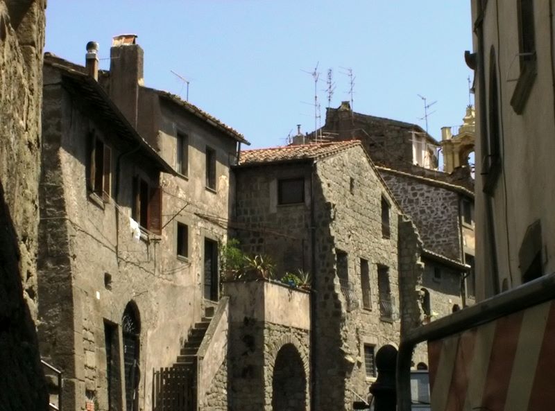
Bagnoregio (Bagnoregio)
.svg)
- Italian comune
 Hiking in Bagnoregio
Bagnoregio, often referred to as the "dying town," is a picturesque hilltop village located in the Lazio region of Italy. It sits atop a hill overlooking the Tiber River Valley and is known for its stunning views and unique geology. Hiking in this area can be a rewarding experience, combining natural beauty with historical exploration.
Hiking Trails and Routes
-
Civita di Bagnoregio Trail:
- Distance: Approximately 1 km (0.6 miles) from Bagnoregio to Civita.
- Difficulty: Easy.
- This short trail connects Bagnoregio with the neighboring village of Civita di Bagnoregio. It is well-maintained and offers stunning views of the surrounding landscape. The path is mostly paved and features scenic overlooks.
-
Rocca di Bagnoregio:
- A more challenging hike can be found around the ancient fortress of Rocca di Bagnoregio. Trails in this area will take you through dense woods and rocky terrains, offering a chance to explore the ruins and enjoy panoramic views of the valley.
-
Valle dei Calanchi:
- This area features striking clay formations known as "calanchi." There are several trails that wind through this unique landscape, providing opportunities for photographers and nature lovers alike.
-
Sentiero del Sole (Sun Trail):
- This hiking route offers a longer loop that encompasses various natural landscapes, cultural sites, and panoramic views. It’s a great way to immerse yourself in the natural beauty surrounding Bagnoregio.
What to Bring
- Hiking Shoes: Comfortable, sturdy footwear is essential as some paths can be uneven or steep.
- Water: Always stay hydrated, especially when hiking during warmer months.
- Snacks: Energetic snacks can keep your stamina up while exploring.
- Camera: Bagnoregio is exceptionally photogenic, so don’t forget to capture the scenery.
- Sun Protection: Wear a hat and bring sunscreen, particularly during the summer months.
Best Time to Visit
- Spring (April to June): Mild temperatures and blooming flowers make this a beautiful time to hike.
- Fall (September to October): The autumn foliage provides spectacular colors across the landscape.
Local Culture and History
While hiking, take the opportunity to explore Bagnoregio itself, with its charming streets, historical architecture, and local cuisine. Be sure to visit local shops and enjoy a meal featuring regional dishes.
Hiking Etiquette
- Stay on marked paths to preserve the natural environment.
- Carry out what you carry in—leave no trace behind.
- Respect local wildlife and plant life.
Hiking in Bagnoregio offers both the thrill of physical activity and the chance to delve into Italy's rich cultural heritage. Enjoy your hike!
- Country:

- Postal Code: 01022
- Local Dialing Code: 0761
- Licence Plate Code: VT
- Coordinates: 42° 37' 48" N, 12° 5' 21" E


- GPS tracks (wikiloc): [Link]
- AboveSeaLevel: 484 м m
- Area: 72.81 sq km
- Population: 3609
- Web site: http://www.comune.bagnoregio.vt.it
- Wikipedia en: wiki(en)
- Wikipedia: wiki(it)
- Wikidata storage: Wikidata: Q159498
- Wikipedia Commons Category: [Link]
- Freebase ID: [/m/0gm3qh]
- GeoNames ID: Alt: [6540496]
- VIAF ID: Alt: [126127018]
- OSM relation ID: [42090]
- GND ID: Alt: [4428387-8]
- UN/LOCODE: [ITZIM]
- Digital Atlas of the Roman Empire ID: [16584]
- Pleiades ID: [413052]
- ISTAT ID: 056003
- Italian cadastre code: A577
Shares border with regions:

Viterbo
- Italian comune
Hiking in Viterbo
Viterbo, located in the Lazio region of Italy, is surrounded by beautiful natural landscapes that make it a fantastic destination for hiking enthusiasts. Here are some highlights about hiking in and around Viterbo:...
- Country:
- Postal Code: 01100
- Local Dialing Code: 0761
- Licence Plate Code: VT
- Coordinates: 42° 25' 7" N, 12° 6' 15" E
- GPS tracks (wikiloc): [Link]
- AboveSeaLevel: 326 м m
- Area: 406.28 sq km
- Population: 67420
- Web site: [Link]
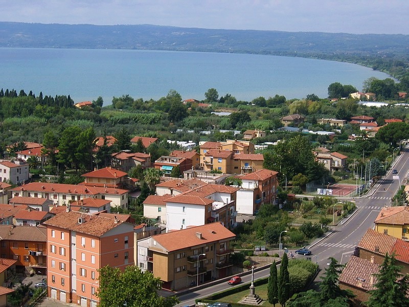

Bolsena
- Italian comune
Hiking in Bolsena
Bolsena, located in the Lazio region of Italy, is known for its stunning natural beauty and historical significance, making it an excellent destination for hiking enthusiasts. Here are some key points and recommendations for hiking in and around Bolsena:...
- Country:
- Postal Code: 01023
- Local Dialing Code: 0761
- Licence Plate Code: VT
- Coordinates: 42° 38' 41" N, 11° 59' 9" E
- GPS tracks (wikiloc): [Link]
- AboveSeaLevel: 350 м m
- Area: 63.57 sq km
- Population: 3941
- Web site: [Link]
Castiglione in Teverina
- Italian comune
Hiking in Castiglione in Teverina
Castiglione in Teverina is a charming village located in the province of Viterbo, in the Lazio region of Italy. Nestled in the picturesque landscape of the Tuscia area, it offers a variety of hiking opportunities for outdoor enthusiasts....
- Country:
- Postal Code: 01024
- Local Dialing Code: 0761
- Licence Plate Code: VT
- Coordinates: 42° 38' 56" N, 12° 12' 15" E
- GPS tracks (wikiloc): [Link]
- AboveSeaLevel: 228 м m
- Area: 19.89 sq km
- Population: 2321
- Web site: [Link]


Celleno
- Italian comune
Hiking in Celleno
Celleno, a charming town located in the Lazio region of Italy, offers beautiful hiking opportunities that showcase its stunning landscapes, historical sites, and a rich natural environment. Here are some highlights of hiking in Celleno:...
- Country:
- Postal Code: 01020
- Local Dialing Code: 0761
- Licence Plate Code: VT
- Coordinates: 42° 33' 39" N, 12° 8' 14" E
- GPS tracks (wikiloc): [Link]
- AboveSeaLevel: 407 м m
- Area: 23.82 sq km
- Population: 1336
- Web site: [Link]
Civitella d'Agliano
- Italian comune
Hiking in Civitella d'Agliano
Civitella d'Agliano is a charming village in Italy, located in the province of Viterbo in the Lazio region. Surrounded by beautiful landscapes, rolling hills, and lush vineyards, it offers some wonderful hiking opportunities for outdoor enthusiasts. Here are some highlights about hiking in and around Civitella d'Agliano:...
- Country:
- Postal Code: 01020
- Local Dialing Code: 0761
- Licence Plate Code: VT
- Coordinates: 42° 36' 15" N, 12° 11' 16" E
- GPS tracks (wikiloc): [Link]
- AboveSeaLevel: 262 м m
- Area: 32.96 sq km
- Population: 1557
- Web site: [Link]


Lubriano
- Italian comune
Hiking in Lubriano
Lubriano is a charming village located in the Italian region of Lazio, specifically in the province of Viterbo. It sits atop a hill, offering stunning views of the surrounding landscapes, including the nearby Necropolis of Tarquinia and the beautiful countryside of the Tuscia region. Hiking in and around Lubriano provides an excellent opportunity to explore this picturesque area rich in history and natural beauty....
- Country:
- Postal Code: 01020
- Local Dialing Code: 0761
- Licence Plate Code: VT
- Coordinates: 42° 38' 13" N, 12° 6' 34" E
- GPS tracks (wikiloc): [Link]
- AboveSeaLevel: 441 м m
- Area: 16.61 sq km
- Population: 893
- Web site: [Link]

Montefiascone
- Italian comune
Hiking in Montefiascone
Montefiascone, located near the shores of Lake Bolsena in Italy's Lazio region, offers a variety of scenic hiking opportunities. The area is characterized by beautiful landscapes, charming medieval architecture, and rich historical significance. Here are some key points about hiking in this region:...
- Country:
- Postal Code: 01027
- Local Dialing Code: 0761
- Licence Plate Code: VT
- Coordinates: 42° 32' 33" N, 12° 1' 55" E
- GPS tracks (wikiloc): [Link]
- AboveSeaLevel: 590 м m
- Area: 104.93 sq km
- Population: 13498
- Web site: [Link]


Orvieto
- Italian comune
Hiking in Orvieto
Orvieto, a stunning hilltop town in Italy's Umbria region, offers fantastic hiking opportunities with breathtaking views and rich historical contexts. Here are some highlights about hiking in and around Orvieto:...
- Country:
- Postal Code: 05018
- Local Dialing Code: 0763
- Licence Plate Code: TR
- Coordinates: 42° 43' 0" N, 12° 6' 0" E
- GPS tracks (wikiloc): [Link]
- AboveSeaLevel: 325 м m
- Area: 281.27 sq km
- Population: 20468
- Web site: [Link]