Bain-de-Bretagne (Bain-de-Bretagne)

- commune in Ille-et-Vilaine, France
- Country:

- Postal Code: 35470
- Coordinates: 47° 50' 39" N, 1° 41' 5" E


- GPS tracks (wikiloc): [Link]
- Area: 64.77 sq km
- Population: 7335
- Web site: http://www.baindebretagne.fr/
- Wikipedia en: wiki(en)
- Wikipedia: wiki(fr)
- Wikidata storage: Wikidata: Q225183
- Wikipedia Commons Category: [Link]
- Freebase ID: [/m/03c8p7q]
- Freebase ID: [/m/03c8p7q]
- GeoNames ID: Alt: [3035324]
- GeoNames ID: Alt: [3035324]
- SIREN number: [213500127]
- SIREN number: [213500127]
- BnF ID: [15256956s]
- BnF ID: [15256956s]
- VIAF ID: Alt: [139517957]
- VIAF ID: Alt: [139517957]
- OSM relation ID: [909655]
- OSM relation ID: [909655]
- archINFORM location ID: [45358]
- archINFORM location ID: [45358]
- Library of Congress authority ID: Alt: [n00037260]
- Library of Congress authority ID: Alt: [n00037260]
- PACTOLS thesaurus ID: [pcrtt2HYcncLUg]
- PACTOLS thesaurus ID: [pcrtt2HYcncLUg]
- WOEID: [577883]
- WOEID: [577883]
- INSEE municipality code: 35012
- INSEE municipality code: 35012
Shares border with regions:


Pléchâtel
- commune in Ille-et-Vilaine, France
- Country:
- Postal Code: 35470
- Coordinates: 47° 53' 40" N, 1° 44' 55" E
- GPS tracks (wikiloc): [Link]
- Area: 36.32 sq km
- Population: 2716
- Web site: [Link]


La Bosse-de-Bretagne
- commune in Ille-et-Vilaine, France
- Country:
- Postal Code: 35320
- Coordinates: 47° 52' 10" N, 1° 35' 56" E
- GPS tracks (wikiloc): [Link]
- Area: 10.21 sq km
- Population: 647

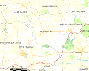
La Dominelais
- commune in Ille-et-Vilaine, France
- Country:
- Postal Code: 35390
- Coordinates: 47° 45' 45" N, 1° 41' 18" E
- GPS tracks (wikiloc): [Link]
- Area: 32.45 sq km
- Population: 1350


Saint-Sulpice-des-Landes
- commune in Ille-et-Vilaine, France
- Country:
- Postal Code: 35390
- Coordinates: 47° 46' 0" N, 1° 37' 23" E
- GPS tracks (wikiloc): [Link]
- AboveSeaLevel: 45 м m
- Area: 11.19 sq km
- Population: 792

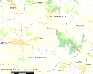
Mernel
- commune in Ille-et-Vilaine, France
- Country:
- Postal Code: 35330
- Coordinates: 47° 53' 52" N, 1° 58' 2" E
- GPS tracks (wikiloc): [Link]
- Area: 17.37 sq km
- Population: 1047
- Web site: [Link]

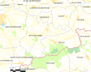
Ercé-en-Lamée
- commune in Ille-et-Vilaine, France
- Country:
- Postal Code: 35620
- Coordinates: 47° 49' 49" N, 1° 33' 33" E
- GPS tracks (wikiloc): [Link]
- Area: 39.21 sq km
- Population: 1504
- Web site: [Link]


La Noë-Blanche
- commune in Ille-et-Vilaine, France
- Country:
- Postal Code: 35470
- Coordinates: 47° 48' 9" N, 1° 44' 29" E
- GPS tracks (wikiloc): [Link]
- Area: 23.18 sq km
- Population: 981
- Web site: [Link]


Pancé
- commune in Ille-et-Vilaine, France
- Country:
- Postal Code: 35320
- Coordinates: 47° 52' 53" N, 1° 39' 30" E
- GPS tracks (wikiloc): [Link]
- Area: 19.33 sq km
- Population: 1156
- Web site: [Link]