Saint-Sulpice-des-Landes (Saint-Sulpice-des-Landes)

- commune in Ille-et-Vilaine, France
- Country:

- Postal Code: 35390
- Coordinates: 47° 46' 0" N, 1° 37' 23" E


- GPS tracks (wikiloc): [Link]
- AboveSeaLevel: 45 м m
- Area: 11.19 sq km
- Population: 792
- Wikipedia en: wiki(en)
- Wikipedia: wiki(fr)
- Wikidata storage: Wikidata: Q1070544
- Wikipedia Commons Category: [Link]
- Freebase ID: [/m/03mf059]
- Freebase ID: [/m/03mf059]
- Freebase ID: [/m/03mf059]
- GeoNames ID: Alt: [6616615]
- GeoNames ID: Alt: [6616615]
- GeoNames ID: Alt: [6616615]
- SIREN number: [213503162]
- SIREN number: [213503162]
- SIREN number: [213503162]
- BnF ID: [15257257f]
- BnF ID: [15257257f]
- BnF ID: [15257257f]
- OSM relation ID: [146042]
- OSM relation ID: [146042]
- OSM relation ID: [146042]
- INSEE municipality code: 35316
- INSEE municipality code: 35316
- INSEE municipality code: 35316
Shares border with regions:

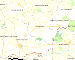
La Dominelais
- commune in Ille-et-Vilaine, France
- Country:
- Postal Code: 35390
- Coordinates: 47° 45' 45" N, 1° 41' 18" E
- GPS tracks (wikiloc): [Link]
- Area: 32.45 sq km
- Population: 1350


Ruffigné
- commune in Loire-Atlantique, France
- Country:
- Postal Code: 44660
- Coordinates: 47° 45' 25" N, 1° 29' 37" E
- GPS tracks (wikiloc): [Link]
- Area: 33.63 sq km
- Population: 714
- Web site: [Link]


Bain-de-Bretagne
- commune in Ille-et-Vilaine, France
- Country:
- Postal Code: 35470
- Coordinates: 47° 50' 39" N, 1° 41' 5" E
- GPS tracks (wikiloc): [Link]
- Area: 64.77 sq km
- Population: 7335
- Web site: [Link]

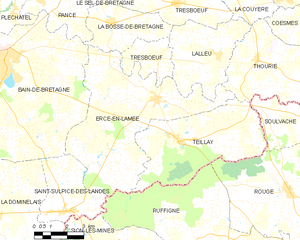
Ercé-en-Lamée
- commune in Ille-et-Vilaine, France
- Country:
- Postal Code: 35620
- Coordinates: 47° 49' 49" N, 1° 33' 33" E
- GPS tracks (wikiloc): [Link]
- Area: 39.21 sq km
- Population: 1504
- Web site: [Link]


Sion-les-Mines
- commune in Loire-Atlantique, France
- Country:
- Postal Code: 44590
- Coordinates: 47° 44' 6" N, 1° 35' 31" E
- GPS tracks (wikiloc): [Link]
- Area: 54.71 sq km
- Population: 1612
- Web site: [Link]