Bajardo (Bajardo)
- Italian comune
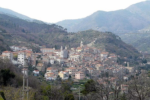
Bajardo, a charming village located in the Liguria region of Italy, offers some beautiful hiking opportunities, particularly for those who appreciate nature and stunning landscapes. Nestled in the hills of the Italian Riviera, it's surrounded by lush greenery, picturesque vistas, and a rich cultural heritage.
Hiking Trails
-
Via dei Monti Ligure: This long-distance trail runs through the Ligurian mountains and passes near Bajardo. It offers a series of connected paths that showcase the region's natural beauty, with varying difficulty levels for hikers of all abilities.
-
Bajardo to San Romolo: This scenic hike takes you from Bajardo to the nearby village of San Romolo. The route is relatively moderate and provides panoramic views of the surrounding countryside and the Mediterranean Sea in the distance.
-
Monte Bignone: For those looking for a more challenging hike, the trail to Monte Bignone offers a rewarding experience. The summit provides breathtaking views of the sea and the surrounding mountains.
Tips for Hiking in Bajardo
- Prepare Properly: Bring adequate supplies, such as water, snacks, a first-aid kit, and appropriate clothing for changing weather conditions.
- Check Trail Conditions: Before heading out, check local resources or with local hiking groups to ensure trails are open and safe.
- Respect Nature: Follow the Leave No Trace principles to minimize your impact on the environment.
- Local Guidance: If you’re unfamiliar with the area or want to learn more about the local flora and fauna, consider hiring a local guide.
Best Time to Go
The ideal seasons for hiking in Bajardo are spring (April to June) and autumn (September to October) when the weather is mild, and the landscape is lush. Summer can be quite hot, while winter may present challenges with snow in higher elevations.
Cultural and Historical Aspects
In addition to the natural beauty, Bajardo itself is rich in history and culture, featuring ancient stone houses and several historical sites. After a day of hiking, exploring the village can be a great way to round out your experience, enjoying local cuisine and hospitality.
Overall, hiking in Bajardo can be a rewarding experience, blending exercise, exploration, and the beauty of the Ligurian landscape.
- Country:

- Postal Code: 18031
- Local Dialing Code: 0184
- Licence Plate Code: IM
- Coordinates: 43° 54' 13" N, 7° 43' 6" E


- GPS tracks (wikiloc): [Link]
- AboveSeaLevel: 900 м m
- Area: 24.32 sq km
- Population: 326
- Web site: http://www.comunebajardo.it
- Wikipedia en: wiki(en)
- Wikipedia: wiki(it)
- Wikidata storage: Wikidata: Q268168
- Wikipedia Commons Category: [Link]
- Freebase ID: [/m/0gby7s]
- GeoNames ID: Alt: [6542792]
- VIAF ID: Alt: [311731867]
- OSM relation ID: [42714]
- MusicBrainz area ID: [06c87780-5d56-43a6-9d93-47ef2346e408]
- ISTAT ID: 008007
- Italian cadastre code: A581
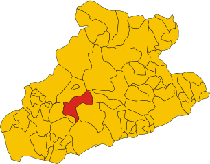
Shares border with regions:


Apricale
- Italian comune
Apricale, a picturesque village in the Liguria region of Italy, offers some fantastic hiking opportunities. Nestled in the Sanremo valleys and surrounded by lush vegetation, it boasts beautiful landscapes, historical sites, and a rich cultural experience....
- Country:

- Postal Code: 18035
- Local Dialing Code: 0184
- Licence Plate Code: IM
- Coordinates: 43° 52' 50" N, 7° 39' 38" E


- GPS tracks (wikiloc): [Link]
- AboveSeaLevel: 291 м m
- Area: 19.94 sq km
- Population: 618
- Web site: [Link]


Badalucco
- Italian comune
Badalucco is a charming village located in the province of Imperia, in the Liguria region of Italy. Nestled in the foothills of the Alps, it offers a number of hiking opportunities that provide stunning views of the surrounding mountains and the nearby coastline....
- Country:

- Postal Code: 18010
- Local Dialing Code: 0184
- Licence Plate Code: IM
- Coordinates: 43° 54' 57" N, 7° 50' 49" E


- GPS tracks (wikiloc): [Link]
- AboveSeaLevel: 179 м m
- Area: 16.1 sq km
- Population: 1123
- Web site: [Link]


Castel Vittorio
- Italian comune
Castel Vittorio, a charming medieval village located in the Italian region of Liguria, is nestled in the scenic hills of the Nervia Valley. Hiking in this area offers a mix of natural beauty, cultural heritage, and various trails suitable for different skill levels....
- Country:

- Postal Code: 18030
- Local Dialing Code: 0184
- Licence Plate Code: IM
- Coordinates: 43° 55' 40" N, 7° 40' 27" E


- GPS tracks (wikiloc): [Link]
- AboveSeaLevel: 420 м m
- Area: 25.93 sq km
- Population: 288
- Web site: [Link]


Ceriana
- Italian comune
Ceriana is a charming medieval village located in the Italian region of Liguria, not far from the beautiful Ligurian coast and the Riviera dei Fiori. The area boasts stunning landscapes, with rolling hills, olive groves, and panoramic views of the surrounding countryside and the sea. Here are some key highlights for hiking in and around Ceriana:...
- Country:

- Postal Code: 18034
- Local Dialing Code: 0184
- Licence Plate Code: IM
- Coordinates: 43° 52' 45" N, 7° 46' 29" E


- GPS tracks (wikiloc): [Link]
- AboveSeaLevel: 369 м m
- Area: 31.79 sq km
- Population: 1214
- Web site: [Link]


Molini di Triora
- Italian comune
Molini di Triora is a picturesque village located in the Liguria region of Italy, nestled in the mountains of the Impero Valley. This area is rich in natural beauty, historical significance, and offers plenty of hiking opportunities for enthusiasts....
- Country:

- Postal Code: 18010
- Local Dialing Code: 0184
- Licence Plate Code: IM
- Coordinates: 43° 59' 25" N, 7° 46' 29" E


- GPS tracks (wikiloc): [Link]
- AboveSeaLevel: 460 м m
- Area: 58.05 sq km
- Population: 604
- Web site: [Link]


Perinaldo
- Italian comune
Perinaldo is a charming village located in the Italian region of Liguria, known for its stunning natural landscapes and historic architecture. It's situated in the hills above the Riviera dei Fiori, offering excellent opportunities for hiking and outdoor activities. Here are some key points about hiking in Perinaldo:...
- Country:

- Postal Code: 18032
- Local Dialing Code: 0184
- Licence Plate Code: IM
- Coordinates: 43° 52' 1" N, 7° 40' 28" E


- GPS tracks (wikiloc): [Link]
- AboveSeaLevel: 572 м m
- Area: 20.3 sq km
- Population: 871
- Web site: [Link]


Sanremo
- Italian comune
Sanremo, located on the Italian Riviera in the region of Liguria, is well-known for its beautiful landscapes, mild climate, and stunning coastal views. Hiking in and around Sanremo offers a wonderful opportunity to explore the natural beauty of the area, from the Mediterranean coast to the surrounding hills and mountains. Here are some highlights and tips for hiking in Sanremo:...
- Country:

- Postal Code: 18038
- Local Dialing Code: 0184
- Licence Plate Code: IM
- Coordinates: 43° 49' 17" N, 7° 47' 12" E


- GPS tracks (wikiloc): [Link]
- AboveSeaLevel: 15 м m
- Area: 55.96 sq km
- Population: 54824
- Web site: [Link]

