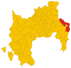
Ballao (Ballao)
%20-%202016.svg)
- Italian comune
 Hiking in Ballao
Ballao is a small town located in the province of Cagliari in Sardinia, Italy. It is surrounded by beautiful landscapes that are ideal for hiking enthusiasts. While it may not be as well-known as some other hiking destinations, it offers a variety of trails that cater to different skill levels and preferences.
Hiking Highlights in Ballao:
-
Natural Beauty: The area is characterized by stunning natural scenery, including rugged hills, valleys, and lush vegetation. The diverse flora and fauna make it a scenic destination for nature lovers.
-
Trail Options: There are several hiking trails around Ballao that range from easy walks to more challenging treks. The trails often lead through picturesque landscapes and may pass by ancient ruins or rural farmland.
-
Cultural Experience: Hiking in this region also allows you to experience the local culture of Sardinia. You may encounter traditional shepherds, ancient stone structures, and local wildlife.
-
Nearby Natural Parks: Consider visiting nearby natural parks, like the Gennargentu National Park, which offers more extensive trail networks and breathtaking views.
-
Planning Your Hike: Make sure to check the weather conditions and prepare accordingly. It's advisable to carry enough water, food, and a first-aid kit. Familiarize yourself with the trail map and let someone know about your hiking plans.
-
Best Time to Hike: The best times for hiking in Ballao are typically during the spring and fall when the weather is mild and the landscapes are vibrant.
-
Local Guides: If you're unfamiliar with the area, consider hiring a local guide who can provide insights about the best trails and safety tips.
Always be respectful of the local environment and culture while hiking, and enjoy the natural beauty and tranquility that Ballao has to offer!
- Country:

- Postal Code: 09040
- Local Dialing Code: 070
- Licence Plate Code: SU
- Coordinates: 39° 32' 56" N, 9° 21' 46" E


- GPS tracks (wikiloc): [Link]
- AboveSeaLevel: 98 м m
- Area: 46.63 sq km
- Population: 790
- Web site: http://www.comune.ballao.ca.it
- Wikipedia en: wiki(en)
- Wikipedia: wiki(it)
- Wikidata storage: Wikidata: Q283625
- Wikipedia Commons Category: [Link]
- Freebase ID: [/m/0gqx1f]
- Freebase ID: [/m/0gqx1f]
- GeoNames ID: Alt: [6537889]
- GeoNames ID: Alt: [6537889]
- VIAF ID: Alt: [132429883]
- VIAF ID: Alt: [132429883]
- OSM relation ID: [39970]
- OSM relation ID: [39970]
- ISTAT ID: 111003
- ISTAT ID: 111003
- Italian cadastre code: A597
- Italian cadastre code: A597
Shares border with regions:


Escalaplano
- Italian comune
Hiking in Escalaplano
Escalaplano is a charming village located in the province of Nuoro, in the heart of Sardinia, Italy. It offers a unique blend of stunning natural landscapes, rich history, and traditional Sardinian culture. Here are some insights into hiking in and around Escalaplano:...
- Country:
- Postal Code: 08043
- Local Dialing Code: 070
- Licence Plate Code: SU
- Coordinates: 39° 37' 29" N, 9° 21' 7" E
- GPS tracks (wikiloc): [Link]
- AboveSeaLevel: 338 м m
- Area: 94.04 sq km
- Population: 2154
- Web site: [Link]


Armungia
- Italian comune
Hiking in Armungia
Armungia, a small village in the province of Cagliari in Sardinia, Italy, is surrounded by beautiful natural landscapes that offer great hiking opportunities. The region is characterized by its rugged terrain, rolling hills, and scenic views, making it ideal for outdoor enthusiasts....
- Country:
- Postal Code: 09040
- Local Dialing Code: 070
- Licence Plate Code: SU
- Coordinates: 39° 31' 19" N, 9° 22' 52" E
- GPS tracks (wikiloc): [Link]
- AboveSeaLevel: 366 м m
- Area: 54.75 sq km
- Population: 459
- Web site: [Link]


Goni
- Italian comune
Hiking in Goni
Goni is a region that offers diverse hiking opportunities, characterized by stunning landscapes and rich biodiversity. While it may not be as widely known as major hiking destinations, it can still provide an excellent experience for outdoor enthusiasts. Here are some key points to consider when hiking in Goni:...
- Country:
- Postal Code: 09040
- Local Dialing Code: 070
- Licence Plate Code: SU
- Coordinates: 39° 34' 43" N, 9° 17' 8" E
- GPS tracks (wikiloc): [Link]
- AboveSeaLevel: 383 м m
- Area: 18.6 sq km
- Population: 478
- Web site: [Link]


Muravera
- Italian comune
Hiking in Muravera
Muravera is a beautiful town located on the southeastern coast of Sardinia, Italy. Known for its stunning landscapes, beautiful beaches, and lush countryside, it offers an array of hiking opportunities that appeal to both novice and experienced outdoors enthusiasts. Here’s an overview of what you can expect when you consider hiking in and around Muravera:...
- Country:
- Postal Code: 09043
- Local Dialing Code: 070
- Licence Plate Code: SU
- Coordinates: 39° 25' 11" N, 9° 34' 35" E
- GPS tracks (wikiloc): [Link]
- AboveSeaLevel: 9 м m
- Area: 93.51 sq km
- Population: 5273
- Web site: [Link]
San Nicolò Gerrei
- Italian comune
Hiking in San Nicolò Gerrei
San Nicolò Gerrei is a charming area in the province of Cagliari, Sardinia, characterized by its beautiful landscapes, rich flora and fauna, and traditional Sardinian culture. Hiking in this region offers a unique opportunity to explore the stunning natural beauty, including mountains, forests, and striking geological formations....
- Country:
- Postal Code: 09040
- Local Dialing Code: 070
- Licence Plate Code: SU
- Coordinates: 39° 29' 50" N, 9° 18' 21" E
- GPS tracks (wikiloc): [Link]
- AboveSeaLevel: 365 м m
- Area: 63.52 sq km
- Population: 769
- Web site: [Link]


San Vito
- Italian comune
Hiking in San Vito
San Vito is located in the province of Vibo Valentia in Calabria, Italy, and is known for its stunning natural landscapes, picturesque villages, and rich cultural history. Here’s what you should know about hiking in the San Vito area:...
- Country:
- Postal Code: 09040
- Local Dialing Code: 070
- Licence Plate Code: SU
- Coordinates: 39° 26' 31" N, 9° 32' 26" E
- GPS tracks (wikiloc): [Link]
- AboveSeaLevel: 10 м m
- Area: 231.64 sq km
- Population: 3632
- Web site: [Link]
Silius
- Italian comune
Hiking in Silius
Silius, located in Sardinia, Italy, is a beautiful destination for hiking enthusiasts. The region boasts a diverse landscape, combining lush forests, rugged mountains, and stunning coastal views. Here’s a general overview of what you can expect when hiking in Silius:...
- Country:
- Postal Code: 09040
- Local Dialing Code: 070
- Licence Plate Code: SU
- Coordinates: 39° 31' 1" N, 9° 17' 38" E
- GPS tracks (wikiloc): [Link]
- AboveSeaLevel: 585 м m
- Area: 38.36 sq km
- Population: 1168
- Web site: [Link]

Villaputzu
- Italian comune
Hiking in Villaputzu
Villaputzu, located on the southeastern coast of Sardinia, Italy, is a picturesque location for hiking enthusiasts. The region is characterized by its stunning coastal scenery, traditional Sardinian landscape, and a mild Mediterranean climate, which makes it ideal for outdoor activities year-round....
- Country:
- Postal Code: 09040
- Local Dialing Code: 070
- Licence Plate Code: SU
- Coordinates: 39° 26' 21" N, 9° 34' 34" E
- GPS tracks (wikiloc): [Link]
- AboveSeaLevel: 11 м m
- Area: 181.31 sq km
- Population: 4718
- Web site: [Link]


Perdasdefogu
- Italian comune
Hiking in Perdasdefogu
Perdasdefogu is a charming village located in the Ogliastra region of Sardinia, Italy. Known for its stunning natural landscapes and rich historical background, it offers a variety of hiking opportunities that cater to different skill levels....
- Country:
- Postal Code: 08046
- Local Dialing Code: 0782
- Licence Plate Code: NU
- Coordinates: 39° 40' 48" N, 9° 26' 25" E
- GPS tracks (wikiloc): [Link]
- AboveSeaLevel: 600 м m
- Area: 77.75 sq km
- Population: 1881
- Web site: [Link]