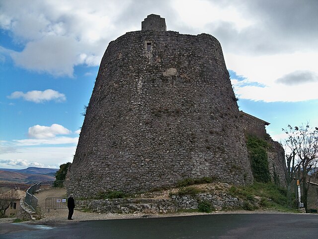
Banon (Banon)
- commune in Alpes-de-Haute-Provence, France
 Hiking in Banon
Banon, situated in the Alpes-de-Haute-Provence region of France, is a charming village known for its picturesque landscapes, rich history, and excellent hiking opportunities. Here's a guide to hiking in and around Banon:
Scenic Trails
-
Tour du Luberon: This is part of a larger circular route that encircles the Luberon mountain range. The trails vary in difficulty and offer breathtaking views of the landscape, vineyards, and the characteristic ochre cliffs.
-
Banon to Pierrevert: This hike takes you through the beautiful countryside surrounding Banon, with gentle slopes and trails that lead to beautiful vistas and hidden spots perfect for picnics.
-
Les Sentiers de la Lavande: Enjoy hiking through the fields of lavender, particularly in late June to early August when the purple blooms are at their peak. This area is not only visually stunning but also fragrant.
What to Expect
- Terrain: The trails around Banon vary from easy walks to more challenging hikes. There are paths suitable for all levels, from families to seasoned hikers.
- Wildlife: Keep an eye out for local wildlife, including deer, birds, and various species of flora and fauna, especially during the spring and fall.
Tips for Hiking in Banon
- Maps and Markers: Always take a map or a GPS device. While many trails are well-marked, having a reliable source of navigation is essential, especially for longer hikes.
- Weather: The weather can change quickly in the mountains, so check forecasts before setting out. Dress in layers and be prepared for sudden changes.
- Hydration and Snacks: Carry plenty of water and snacks. There might not be many places to refill along the trails.
Additional Activities
After a day of hiking, take some time to explore Banon itself. The village is famous for its goat cheese and quaint streets, making it a delightful spot to relax. The local market is also well worth a visit, typically held weekly.
In summary, hiking around Banon offers a wonderful experience filled with natural beauty, varying landscapes, and a chance to enjoy the charm of rural France. Ensure you are well-prepared, respect the environment, and most importantly, enjoy the journey!
- Country:

- Postal Code: 04150
- Coordinates: 44° 2' 17" N, 5° 37' 41" E


- GPS tracks (wikiloc): [Link]
- Area: 39.81 sq km
- Population: 966
- Web site: http://www.village-banon.fr
- Wikipedia en: wiki(en)
- Wikipedia: wiki(fr)
- Wikidata storage: Wikidata: Q326687
- Wikipedia Commons Category: [Link]
- Freebase ID: [/m/0806lh]
- Freebase ID: [/m/0806lh]
- GeoNames ID: Alt: [6446579]
- GeoNames ID: Alt: [6446579]
- SIREN number: [210400180]
- SIREN number: [210400180]
- BnF ID: [152443584]
- BnF ID: [152443584]
- WOEID: [578037]
- WOEID: [578037]
- SUDOC authorities ID: [131860194]
- SUDOC authorities ID: [131860194]
- INSEE municipality code: 04018
- INSEE municipality code: 04018
Shares border with regions:

Revest-des-Brousses
- commune in Alpes-de-Haute-Provence, France
Hiking in Revest-des-Brousses
Revest-des-Brousses is a charming commune located in the Alpes-de-Haute-Provence region of southeastern France. This area offers a variety of beautiful hiking opportunities, surrounded by stunning landscapes of hills, forests, and rural vistas....
- Country:
- Postal Code: 04150
- Coordinates: 43° 58' 19" N, 5° 40' 18" E
- GPS tracks (wikiloc): [Link]
- Area: 22.95 sq km
- Population: 271

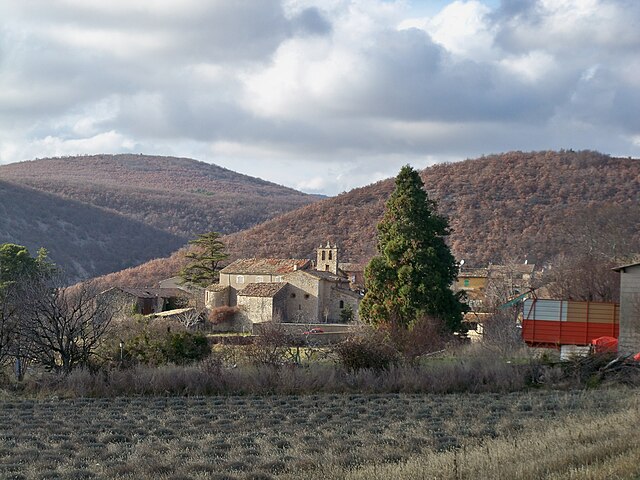
La Rochegiron
- commune in Alpes-de-Haute-Provence, France
Hiking in La Rochegiron
La Rochegiron, located in the Auvergne region of France, is a wonderful destination for hiking enthusiasts. With its picturesque landscapes, scenic views, and a variety of trails, it caters to both novice and experienced hikers. Here’s a bit more information about what you can expect when hiking in the area:...
- Country:
- Postal Code: 04150
- Coordinates: 44° 4' 39" N, 5° 39' 20" E
- GPS tracks (wikiloc): [Link]
- Area: 30.11 sq km
- Population: 93

Montsalier
- commune in Alpes-de-Haute-Provence, France
Hiking in Montsalier
Montsalier is a wonderful destination for hiking enthusiasts, located in the beautiful region of Provence-Alpes-Côte d'Azur in southeastern France. The area offers a variety of trails that cater to different skill levels, from leisurely walks to more challenging hikes. Here are some key points to consider:...
- Country:
- Postal Code: 04150
- Coordinates: 44° 0' 44" N, 5° 36' 33" E
- GPS tracks (wikiloc): [Link]
- AboveSeaLevel: 630 м m
- Area: 23.81 sq km
- Population: 127

Saumane
- commune in Alpes-de-Haute-Provence, France
Hiking in Saumane
Saumane, located in the Alpes-de-Haute-Provence region of southeastern France, offers a beautiful and diverse landscape for hiking enthusiasts. This area is characterized by its beautiful scenery, rolling hills, and a variety of trails suitable for all skill levels. Here are some key points to consider for hiking in Saumane:...
- Country:
- Postal Code: 04150
- Coordinates: 44° 5' 26" N, 5° 41' 26" E
- GPS tracks (wikiloc): [Link]
- Area: 3.21 sq km
- Population: 111

Ongles
- commune in Alpes-de-Haute-Provence, France
Hiking in Ongles
Ongles, located in the Alpes-de-Haute-Provence region of France, offers a unique hiking experience characterized by stunning landscapes, charming rustic villages, and a rich natural environment. Whether you're an experienced hiker or a beginner, you'll find various trails that cater to different skill levels....
- Country:
- Postal Code: 04230
- Coordinates: 44° 1' 40" N, 5° 44' 1" E
- GPS tracks (wikiloc): [Link]
- Area: 31.46 sq km
- Population: 363

Redortiers
- commune in Alpes-de-Haute-Provence, France
Hiking in Redortiers
Redortiers is a picturesque village located in the Drôme department of southeastern France, nestled in the beautiful landscape of the Provence region. The area is surrounded by stunning natural scenery, making it an excellent destination for hiking enthusiasts....
- Country:
- Postal Code: 04150
- Coordinates: 44° 6' 17" N, 5° 37' 6" E
- GPS tracks (wikiloc): [Link]
- Area: 45.77 sq km
- Population: 73

Vachères
- commune in Alpes-de-Haute-Provence, France
Hiking in Vachères
Vachères is a charming village located in the Provence-Alpes-Côte d'Azur region of southeastern France. Nestled in the heart of the Luberon area, it offers stunning natural landscapes, picturesque views, and a variety of hiking trails suited for all skill levels. Here are some highlights of hiking in Vachères:...
- Country:
- Postal Code: 04110
- Coordinates: 43° 55' 53" N, 5° 38' 18" E
- GPS tracks (wikiloc): [Link]
- Area: 23.42 sq km
- Population: 264
Simiane-la-Rotonde
- commune in Alpes-de-Haute-Provence, France
Hiking in Simiane-la-Rotonde
Simiane-la-Rotonde is a charming village located in the Provence-Alpes-Côte d'Azur region of southeastern France, known for its picturesque landscapes and rich history. It's an excellent destination for hiking enthusiasts looking to explore the beautiful natural surroundings of the Luberon region....
- Country:
- Postal Code: 04150
- Coordinates: 43° 58' 50" N, 5° 33' 46" E
- GPS tracks (wikiloc): [Link]
- Area: 67.86 sq km
- Population: 592
- Web site: [Link]
Lardiers
- commune in Alpes-de-Haute-Provence, France
Hiking in Lardiers
Lardiers is a small village located in the Alpes-de-Haute-Provence region of France. It's known for its picturesque scenery and offers a variety of hiking opportunities that cater to different skill levels. Here are some key points to consider when hiking in and around Lardiers:...
- Country:
- Postal Code: 04230
- Coordinates: 44° 3' 25" N, 5° 42' 44" E
- GPS tracks (wikiloc): [Link]
- Area: 30.08 sq km
- Population: 112