Barcelonne-du-Gers (Barcelonne-du-Gers)

- commune in Gers, France
- Country:

- Postal Code: 32720
- Coordinates: 43° 42' 12" N, 0° 14' 9" E


- GPS tracks (wikiloc): [Link]
- Area: 20.29 sq km
- Population: 1363
- Web site: http://www.barcelonne-du-gers.fr
- Wikipedia en: wiki(en)
- Wikipedia: wiki(fr)
- Wikidata storage: Wikidata: Q473917
- Wikipedia Commons Category: [Link]
- Freebase ID: [/m/03cfplh]
- Freebase ID: [/m/03cfplh]
- GeoNames ID: Alt: [6448322]
- GeoNames ID: Alt: [6448322]
- SIREN number: [213200272]
- SIREN number: [213200272]
- BnF ID: [15255614s]
- BnF ID: [15255614s]
- VIAF ID: Alt: [249127166]
- VIAF ID: Alt: [249127166]
- PACTOLS thesaurus ID: [pcrt0xUlh9OyWo]
- PACTOLS thesaurus ID: [pcrt0xUlh9OyWo]
- INSEE municipality code: 32027
- INSEE municipality code: 32027
Shares border with regions:
Vergoignan
- commune in Gers, France
- Country:
- Postal Code: 32720
- Coordinates: 43° 43' 4" N, 0° 11' 54" E
- GPS tracks (wikiloc): [Link]
- Area: 10.44 sq km
- Population: 283
Arblade-le-Bas
- commune in Gers, France
- Country:
- Postal Code: 32720
- Coordinates: 43° 42' 26" N, 0° 10' 37" E
- GPS tracks (wikiloc): [Link]
- Area: 7.67 sq km
- Population: 153


Aire-sur-l'Adour
- commune in Landes, France
- Country:
- Postal Code: 40800
- Coordinates: 43° 42' 11" N, 0° 15' 46" E
- GPS tracks (wikiloc): [Link]
- AboveSeaLevel: 80 м m
- Area: 57.78 sq km
- Population: 6099
- Web site: [Link]


Lelin-Lapujolle
- commune in Gers, France
- Country:
- Postal Code: 32400
- Coordinates: 43° 42' 24" N, 0° 8' 47" E
- GPS tracks (wikiloc): [Link]
- AboveSeaLevel: 142.0 м m
- Area: 13.56 sq km
- Population: 267


Bernède
- commune in Gers, France
- Country:
- Postal Code: 32400
- Coordinates: 43° 40' 10" N, 0° 13' 18" E
- GPS tracks (wikiloc): [Link]
- Area: 8.18 sq km
- Population: 206

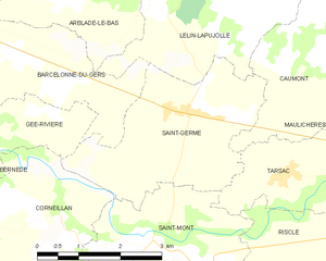
Saint-Germé
- commune in Gers, France
- Country:
- Postal Code: 32400
- Coordinates: 43° 40' 48" N, 0° 8' 47" E
- GPS tracks (wikiloc): [Link]
- Area: 9.55 sq km
- Population: 490


Gée-Rivière
- commune in Gers, France
- Country:
- Postal Code: 32720
- Coordinates: 43° 40' 41" N, 0° 11' 21" E
- GPS tracks (wikiloc): [Link]
- Area: 2.74 sq km
- Population: 46