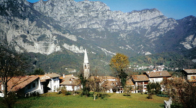
Barcis (Barcis)
.svg)
- Italian comune
 Hiking in Barcis
Barcis is a picturesque village located in the Friuli Venezia Giulia region of northeastern Italy, surrounded by stunning natural landscapes, including mountains, lakes, and forests. Hiking in Barcis offers a fantastic opportunity to explore the beautiful surroundings and experience the region's rich biodiversity.
Trails and Hiking Opportunities:
-
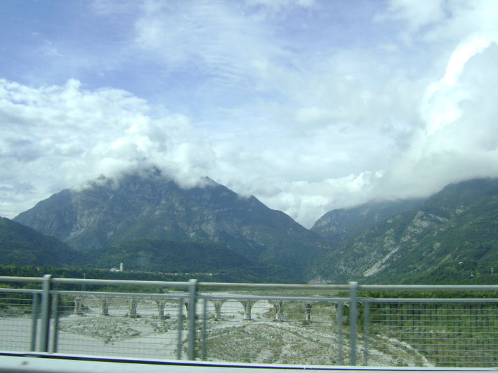
Lago di Barcis: The lake itself is a great starting point for a variety of hiking trails. You can enjoy easy walks along the shoreline, taking in the views of the turquoise waters and the surrounding mountains. The area offers several picnic spots, making it a great place for a family outing.
-
Sentiero del Diavolo (Devil's Path): This more challenging hike leads you through the forest and offers breathtaking views of the Val Cellina. It's a well-marked trail but requires good fitness levels and proper hiking gear.
-
The Three Peaks of Barcis: For those looking for a more strenuous challenge, there are hikes that take you up to the surrounding peaks, including the Monte Rest and Monte D'Avella. The panoramic views from the summits are well worth the effort.
-
Cansiglio Forest: Nearby, the Cansiglio Forest offers numerous trails through lush greenery, rich fauna, and historical sites. This vast area is perfect for those who enjoy longer hikes in uncrowded settings.
Tips for Hiking in Barcis:
-
Seasonal Considerations: The best time for hiking in Barcis is typically from spring to early autumn (April to October). In winter, some trails may be covered in snow and could require technical gear such as crampons or snowshoes.
-
Trail Markings: Most hiking trails in the area are well-marked with signs and colored blazes. However, it’s always advisable to have a map or a GPS device handy.
-
Safety Precautions: Always check the weather forecast before heading out, inform someone about your plans, and bring enough water and snacks. Cell phone reception can be limited in some areas.
-
Wildlife and Flora: Keep your eyes peeled for local wildlife, including deer, foxes, and a variety of bird species. There are also beautiful wildflowers and unique plants along the trails, particularly in spring.
-
Local Etiquette: Follow the principles of "Leave No Trace" by carrying out what you bring in and respecting natural habitats.
Hiking in Barcis can be a rewarding experience, allowing you to connect with nature while enjoying the tranquility of this stunning region. Whether you’re a seasoned hiker or a beginner, there are trails suitable for every level of fitness and experience.
- Country:

- Postal Code: 33080
- Local Dialing Code: 0427
- Licence Plate Code: PN
- Coordinates: 46° 11' 0" N, 12° 34' 0" E


- GPS tracks (wikiloc): [Link]
- AboveSeaLevel: 409 м m
- Area: 103.41 sq km
- Population: 256
- Web site: http://www.barcis.fvg.it
- Wikipedia en: wiki(en)
- Wikipedia: wiki(it)
- Wikidata storage: Wikidata: Q53153
- Wikipedia Commons Category: [Link]
- Freebase ID: [/m/0gqz0s]
- GeoNames ID: Alt: [6537926]
- VIAF ID: Alt: [132686751]
- OSM relation ID: [79141]
- ISTAT ID: 093006
- Italian cadastre code: A640
Shares border with regions:
Tambre
- Italian comune
Hiking in Tambre
Tambre, located in the Veneto region of Italy, is renowned for its stunning landscapes and outdoor activities, especially hiking. The hills and mountains in and around Tambre provide a variety of trails suitable for different skill levels, from leisurely walks to more challenging treks....
- Country:
- Postal Code: 32010
- Local Dialing Code: 0437
- Licence Plate Code: BL
- Coordinates: 46° 8' 0" N, 12° 25' 0" E
- GPS tracks (wikiloc): [Link]
- AboveSeaLevel: 922 м m
- Area: 45.27 sq km
- Population: 1366
- Web site: [Link]


Chies d'Alpago
- Italian comune
Hiking in Chies d'Alpago
Chies d'Alpago is a beautiful destination for hiking enthusiasts, located in the Veneto region of northern Italy. Nestled in the Alps, this area offers stunning views, diverse landscapes, and a variety of trails suitable for all skill levels....
- Country:
- Postal Code: 32010
- Local Dialing Code: 0437
- Licence Plate Code: BL
- Coordinates: 46° 9' 21" N, 12° 23' 22" E
- GPS tracks (wikiloc): [Link]
- AboveSeaLevel: 647 м m
- Area: 44.97 sq km
- Population: 1328
- Web site: [Link]
Andreis
- Propiedad de andreys Calderón
Hiking in Andreis
Andreis is a picturesque village located in the Friuli Venezia Giulia region of northeastern Italy. Surrounded by stunning landscapes, it offers a variety of hiking opportunities for both beginners and experienced adventurers. Here are some highlights and tips for hiking in and around Andreis:...
- Country:
- Postal Code: 33080
- Local Dialing Code: 0427
- Licence Plate Code: PN
- Coordinates: 46° 12' 0" N, 12° 37' 0" E
- GPS tracks (wikiloc): [Link]
- AboveSeaLevel: 455 м m
- Area: 26.95 sq km
- Population: 248
- Web site: [Link]


Aviano
- Italian comune
Hiking in Aviano
Aviano, located in the northeastern part of Italy, is surrounded by beautiful landscapes that offer numerous hiking opportunities for outdoor enthusiasts. Nestled near the Friuli Venezia Giulia region and the Dolomites, the area provides a mix of mountainous terrain, forests, and valleys, making it an excellent destination for hikers of all levels....
- Country:
- Postal Code: 33081
- Local Dialing Code: 0434
- Licence Plate Code: PN
- Coordinates: 46° 4' 0" N, 12° 35' 0" E
- GPS tracks (wikiloc): [Link]
- AboveSeaLevel: 159 м m
- Area: 113.35 sq km
- Population: 9080
- Web site: [Link]


Claut
- Italian comune
Hiking in Claut
Claut is a picturesque village located in the Friuli Venezia Giulia region of northeastern Italy. Nestled in the heart of the Carnic Alps, it offers excellent hiking opportunities for both beginners and experienced hikers. Here are some aspects to consider when hiking in Claut:...
- Country:
- Postal Code: 33080
- Local Dialing Code: 0427
- Licence Plate Code: PN
- Coordinates: 46° 16' 0" N, 12° 31' 0" E
- GPS tracks (wikiloc): [Link]
- AboveSeaLevel: 613 м m
- Area: 165.91 sq km
- Population: 946
- Web site: [Link]

Frisanco
- Italian comune
Hiking in Frisanco
Frisanco, located in the province of Pordenone in the Friuli Venezia Giulia region of Italy, offers a delightful experience for hikers of all levels. The area is surrounded by the beautiful Friulian Dolomites, providing stunning landscapes, varying terrains, and rich natural biodiversity....
- Country:
- Postal Code: 33080
- Local Dialing Code: 0427
- Licence Plate Code: PN
- Coordinates: 46° 13' 0" N, 12° 44' 0" E
- GPS tracks (wikiloc): [Link]
- AboveSeaLevel: 500 м m
- Area: 60.99 sq km
- Population: 600
- Web site: [Link]

Montereale Valcellina
- Italian comune
Hiking in Montereale Valcellina
Montereale Valcellina, located in the Friuli Venezia Giulia region of Italy, offers stunning landscapes and a variety of hiking opportunities for outdoor enthusiasts. The area is known for its rugged mountains, lush forests, and the picturesque Valcellina valley, making it a hidden gem for hikers....
- Country:
- Postal Code: 33086
- Local Dialing Code: 0427
- Licence Plate Code: PN
- Coordinates: 46° 10' 0" N, 12° 40' 0" E
- GPS tracks (wikiloc): [Link]
- AboveSeaLevel: 317 м m
- Area: 67.88 sq km
- Population: 4365
- Web site: [Link]