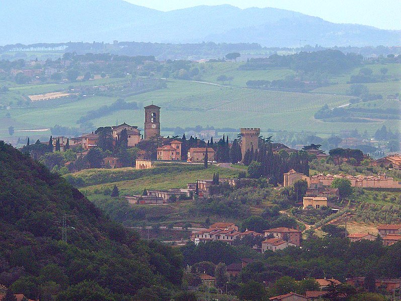
Bastia Umbra (Bastia Umbra)
.svg)
- town in the region Umbria, Italy
 Hiking in Bastia Umbra
Bastia Umbra, located in the region of Umbria in Italy, is a charming town that offers various opportunities for hiking enthusiasts. Nestled near the beautiful city of Assisi and surrounded by the stunning Umbrian landscape, it serves as a fantastic gateway for numerous trails that showcase the region’s natural beauty and rich history.
Key Hiking Areas and Trails
-
Monte Subasio:
- This mountain is one of the most popular hiking destinations near Bastia Umbra. The area features a network of trails that lead to the summit, where hikers can enjoy breathtaking views of Assisi, the surrounding valleys, and even the Apennine Mountains on clear days.
-
Trail to Assisi:
- There are several paths connecting Bastia Umbra to Assisi. These trails often wind through olive groves, vineyards, and picturesque farmland, providing a serene natural ambiance. One of the most famous routes is part of the "Via Francigena," an ancient pilgrimage trail.
-
Park of Mount Subasio:
- This regional park features a variety of well-marked trails that cater to different skill levels. The park is rich in flora and fauna and also includes historical sites such as hermitages and ruins that date back to the time of St. Francis.
Tips for Hiking in Bastia Umbra
-
Best Time to Hike: The ideal seasons for hiking in Bastia Umbra are spring (April to June) and fall (September to October) when temperatures are mild, and the scenery is vibrant.
-
Gear: Wear comfortable, sturdy hiking boots. Depending on the trail, some may require trekking poles. Don't forget essentials like water, snacks, a map, and sun protection.
-
Local Information: Before setting out, check with local visitor centers for trail updates, maps, or guided hiking options. They can provide insights into current conditions and must-see sights.
-
Respect Nature: Follow Leave No Trace principles to preserve the stunning environment. Stay on marked trails and carry out any litter.
By exploring the trails around Bastia Umbra, you not only experience the natural beauty of Umbria but also get a glimpse into its rich cultural and historical heritage. Happy hiking!
- Country:

- Postal Code: 06083
- Local Dialing Code: 075
- Licence Plate Code: PG
- Coordinates: 43° 4' 0" N, 12° 33' 0" E


- GPS tracks (wikiloc): [Link]
- AboveSeaLevel: 200 м m
- Area: 27.6 sq km
- Population: 21773
- Web site: http://www.comune.bastia.pg.it
- Wikipedia en: wiki(en)
- Wikipedia: wiki(it)
- Wikidata storage: Wikidata: Q20126
- Wikipedia Commons Gallery: [Link]
- Wikipedia Commons Category: [Link]
- Freebase ID: [/m/0gm1rd]
- GeoNames ID: Alt: [6542181]
- VIAF ID: Alt: [236873844]
- OSM relation ID: [42302]
- GND ID: Alt: [4217847-2]
- UN/LOCODE: [ITBAS]
- ISTAT ID: 054002
- Italian cadastre code: A710
Shares border with regions:


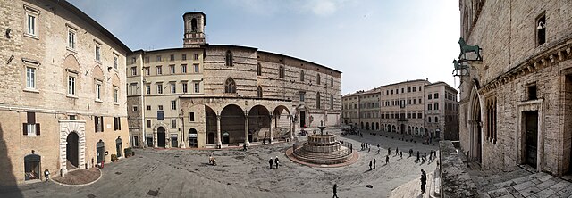
Assisi
- city in Italy
Hiking in Assisi
Hiking in Assisi, a picturesque town in Umbria, Italy, offers a blend of natural beauty, historical significance, and spiritual experience. The region is adorned with rolling hills, olive groves, and vineyards, making it a fantastic destination for both novice and experienced hikers. Here are some highlights:...
- Country:
- Postal Code: 06081
- Local Dialing Code: 075
- Licence Plate Code: PG
- Coordinates: 43° 4' 12" N, 12° 37' 3" E
- GPS tracks (wikiloc): [Link]
- AboveSeaLevel: 424 м m
- Area: 187.19 sq km
- Population: 28290
- Web site: [Link]


Bettona
- Italian comune
Hiking in Bettona
Bettona, a charming medieval town located in the Umbria region of Italy, is not only known for its historic architecture and panoramic views but also offers wonderful hiking opportunities. The surrounding landscape provides a mix of rolling hills, vineyards, olive groves, and woods, making it a great destination for outdoor enthusiasts....
- Country:
- Postal Code: 06084
- Local Dialing Code: 075
- Licence Plate Code: PG
- Coordinates: 43° 1' 0" N, 12° 29' 0" E
- GPS tracks (wikiloc): [Link]
- AboveSeaLevel: 353 м m
- Area: 45.08 sq km
- Population: 4357
- Web site: [Link]

Torgiano
- Italian comune
Hiking in Torgiano
Torgiano, located in the Umbria region of Italy, is a charming town renowned for its stunning landscapes, rich history, and excellent wine production, particularly the famous Torgiano Rosso Wine. Hiking in and around Torgiano offers a variety of experiences, from gentle walks through vineyards to more challenging trails with scenic views of the surrounding hills and valleys....
- Country:
- Postal Code: 06089
- Local Dialing Code: 075
- Licence Plate Code: PG
- Coordinates: 43° 1' 32" N, 12° 26' 3" E
- GPS tracks (wikiloc): [Link]
- AboveSeaLevel: 219 м m
- Area: 37.66 sq km
- Population: 6662
- Web site: [Link]

Perugia
- Italian comune
Hiking in Perugia
Perugia, the capital of the Umbria region in Italy, is known for its rich history, vibrant culture, and beautiful landscapes. Hiking in and around Perugia offers a unique opportunity to explore both its natural beauty and historical sites. Here are some highlights and tips for hiking in this area:...
- Country:
- Postal Code: 06121–06135
- Local Dialing Code: 075
- Licence Plate Code: PG
- Coordinates: 43° 6' 44" N, 12° 23' 20" E
- GPS tracks (wikiloc): [Link]
- AboveSeaLevel: 493 м m
- Area: 449.51 sq km
- Population: 165683
- Web site: [Link]