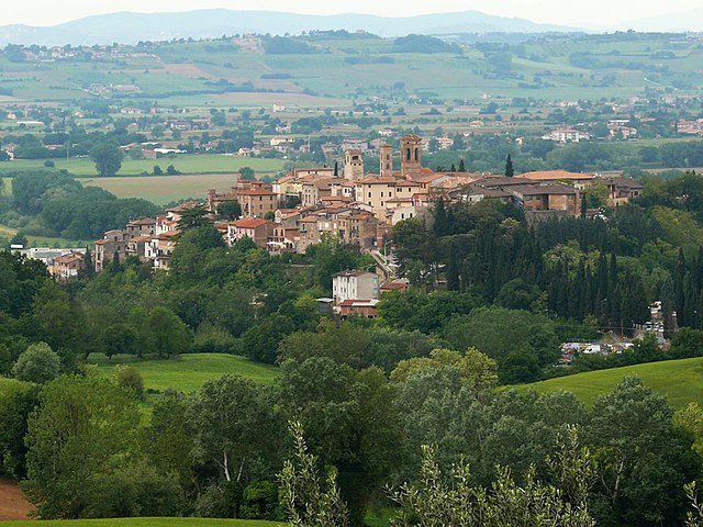
Torgiano (Torgiano)
.svg)
- Italian comune
 Hiking in Torgiano
Torgiano, located in the Umbria region of Italy, is a charming town renowned for its stunning landscapes, rich history, and excellent wine production, particularly the famous Torgiano Rosso Wine. Hiking in and around Torgiano offers a variety of experiences, from gentle walks through vineyards to more challenging trails with scenic views of the surrounding hills and valleys.
Here are some highlights and tips for hiking in Torgiano:
Hiking Trails
-
Vineyard Paths: Many trails wind through the vineyards and olive groves surrounding Torgiano. These paths are generally well-marked and perfect for leisurely walks, allowing you to enjoy the beautiful countryside.
-
The Umbria Wine Trail: This trail connects various towns known for their wine production, including Torgiano. Hiking sections of this trail can give you a chance to explore the region’s rich viticulture.
-
Biodiversity Trails: Explore the natural parks nearby, such as the Monte Tezio Regional Park. Here, you can find a variety of trails that showcase the diverse fauna and flora of the region.
-
Historic Routes: Some trails lead to historical sites and ancient ruins, so you can combine a bit of history with your hiking adventure.
What to Keep in Mind
-
Preparation: Always check trail conditions before heading out. It’s also a good idea to wear appropriate footwear and bring ample water and snacks.
-
Weather: The weather can change rapidly in the hills, so plan accordingly. Spring and fall are ideal for hiking, as the temperatures are generally pleasant.
-
Local Guidance: Consider joining a guided hike or local group. They can provide insight into the area’s history, culture, and natural features that you might miss on your own.
-
Wine Tasting: After your hike, take the opportunity to visit local wineries or enjoy a meal featuring traditional Umbrian dishes paired with local wines.
-
Respect Nature: Follow Leave No Trace principles to protect the beautiful landscapes and preserve them for future generations.
Exploring Torgiano on foot allows you to fully appreciate the charm of this Umbrian town, with its rolling hills, beautiful vineyards, and rich cultural heritage. Enjoy your hiking adventure!
- Country:

- Postal Code: 06089
- Local Dialing Code: 075
- Licence Plate Code: PG
- Coordinates: 43° 1' 32" N, 12° 26' 3" E


- GPS tracks (wikiloc): [Link]
- AboveSeaLevel: 219 м m
- Area: 37.66 sq km
- Population: 6662
- Web site: http://www.comune.torgiano.pg.it
- Wikipedia en: wiki(en)
- Wikipedia: wiki(it)
- Wikidata storage: Wikidata: Q20590
- Wikipedia Commons Gallery: [Link]
- Wikipedia Commons Category: [Link]
- Freebase ID: [/m/0gm2lx]
- GeoNames ID: Alt: [6541117]
- VIAF ID: Alt: [140720531]
- OSM relation ID: [42280]
- GND ID: Alt: [4364932-4]
- WOEID: [725001]
- UN/LOCODE: [ITTXO]
- DMOZ ID: Alt: [Regional/Europe/Italy/Umbria/Localities/Torgiano/]
- ISTAT ID: 054053
- Italian cadastre code: L216
Shares border with regions:


Bastia Umbra
- town in the region Umbria, Italy
Hiking in Bastia Umbra
Bastia Umbra, located in the region of Umbria in Italy, is a charming town that offers various opportunities for hiking enthusiasts. Nestled near the beautiful city of Assisi and surrounded by the stunning Umbrian landscape, it serves as a fantastic gateway for numerous trails that showcase the region’s natural beauty and rich history....
- Country:
- Postal Code: 06083
- Local Dialing Code: 075
- Licence Plate Code: PG
- Coordinates: 43° 4' 0" N, 12° 33' 0" E
- GPS tracks (wikiloc): [Link]
- AboveSeaLevel: 200 м m
- Area: 27.6 sq km
- Population: 21773
- Web site: [Link]


Bettona
- Italian comune
Hiking in Bettona
Bettona, a charming medieval town located in the Umbria region of Italy, is not only known for its historic architecture and panoramic views but also offers wonderful hiking opportunities. The surrounding landscape provides a mix of rolling hills, vineyards, olive groves, and woods, making it a great destination for outdoor enthusiasts....
- Country:
- Postal Code: 06084
- Local Dialing Code: 075
- Licence Plate Code: PG
- Coordinates: 43° 1' 0" N, 12° 29' 0" E
- GPS tracks (wikiloc): [Link]
- AboveSeaLevel: 353 м m
- Area: 45.08 sq km
- Population: 4357
- Web site: [Link]

Deruta
- Italian comune
Hiking in Deruta
Deruta, a charming town in Italy's Umbria region, is primarily known for its rich history and beautiful ceramics. While it may not be as famous for hiking as some other areas in Italy, it offers several opportunities for outdoor enthusiasts looking to explore the scenic beauty and landscape of the Umbrian countryside....
- Country:
- Postal Code: 06053
- Local Dialing Code: 075
- Licence Plate Code: PG
- Coordinates: 42° 59' 0" N, 12° 25' 0" E
- GPS tracks (wikiloc): [Link]
- AboveSeaLevel: 234 м m
- Area: 44.51 sq km
- Population: 9713
- Web site: [Link]
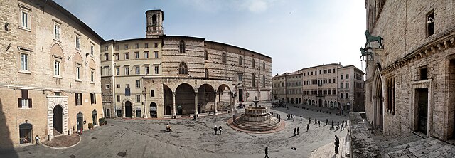

Perugia
- Italian comune
Hiking in Perugia
Perugia, the capital of the Umbria region in Italy, is known for its rich history, vibrant culture, and beautiful landscapes. Hiking in and around Perugia offers a unique opportunity to explore both its natural beauty and historical sites. Here are some highlights and tips for hiking in this area:...
- Country:
- Postal Code: 06121–06135
- Local Dialing Code: 075
- Licence Plate Code: PG
- Coordinates: 43° 6' 44" N, 12° 23' 20" E
- GPS tracks (wikiloc): [Link]
- AboveSeaLevel: 493 м m
- Area: 449.51 sq km
- Population: 165683
- Web site: [Link]