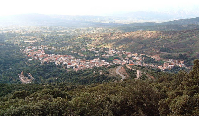
Baunei (Baunei)
%20-%202016.svg)
- Italian comune
 Hiking in Baunei
Baunei, located on the eastern coast of Sardinia, Italy, is a fantastic destination for hiking enthusiasts. It offers stunning landscapes, including dramatic cliffs, lush valleys, and breathtaking sea views. Here are some highlights and popular trails to consider when hiking in Baunei:
1.
- Difficulty: Moderate
- Distance: Approximately 3 km (1.9 miles) one way
- Highlights: This trail leads you to one of Sardinia’s most stunning beaches, Cala Goloritzé, known for its turquoise waters and unique limestone formations. The trail includes some rocky sections, so proper footwear is recommended.
2.
- Difficulty: Moderate to Challenging
- Highlights: This hiking route offers a glimpse into the breathtaking Bue Marino Caves, home to unique geological formations. The hike involves navigating through rugged terrain, and you may also spot local wildlife.
3.
- Difficulty: Moderate
- Distance: Approximately 6 km (3.7 miles) round trip
- Highlights: The hike to the ancient Nuragic settlement of Tiscali features a mix of steep ascents, scenic views, and a fascinating archaeological site. The place itself is situated in a limestone karst, surrounded by nature.
4.
- Difficulty: Moderate
- Distance: About 9 km (5.6 miles) round trip
- Highlights: This picturesque hike takes you through a forested area to the beautiful Cala Sisine beach. Along the way, you can enjoy views of the surrounding cliffs and the blue sea.
5.
- Difficulty: Easy to Moderate
- Distance: Approximately 4 km (2.5 miles) round trip
- Highlights: A shorter hike that provides an excellent opportunity for families or beginners. This path takes you through lush Mediterranean vegetation and offers beautiful coast views.
Tips for Hiking in Baunei:
- Best Time to Hike: Spring (April to June) and fall (September to October) are generally the best times for comfortable weather and fewer crowds.
- Equipment: Wear sturdy hiking boots and bring plenty of water, snacks, sunscreen, and a hat for sun protection. If you're planning a longer hike, consider a backpack.
- Respect Nature: Leave no trace, stay on marked trails, and respect the local flora and fauna.
- Local Guides: If you’re unfamiliar with the area or prefer a guided experience, consider booking a local tour guide who can provide insights into the history and ecology of the region.
Baunei offers a wealth of hiking opportunities that cater to various skill levels, making it a must-visit destination for hikers exploring Sardinia!
- Country:

- Postal Code: 08040
- Local Dialing Code: 0782
- Licence Plate Code: NU
- Coordinates: 40° 1' 51" N, 9° 39' 52" E


- GPS tracks (wikiloc): [Link]
- AboveSeaLevel: 480 м m
- Area: 211.9 sq km
- Population: 3602
- Web site: http://www.comunebaunei.it/
- Wikipedia en: wiki(en)
- Wikipedia: wiki(it)
- Wikidata storage: Wikidata: Q339776
- Wikipedia Commons Gallery: [Link]
- Wikipedia Commons Category: [Link]
- Freebase ID: [/m/0gqv2c]
- Freebase ID: [/m/0gqv2c]
- GeoNames ID: Alt: [6537850]
- GeoNames ID: Alt: [6537850]
- VIAF ID: Alt: [245907331]
- VIAF ID: Alt: [245907331]
- OSM relation ID: [40187]
- OSM relation ID: [40187]
- GND ID: Alt: [7738979-7]
- GND ID: Alt: [7738979-7]
- Library of Congress authority ID: Alt: [no2010137035]
- Library of Congress authority ID: Alt: [no2010137035]
- ISTAT ID: 091006
- ISTAT ID: 091006
- Italian cadastre code: A722
- Italian cadastre code: A722
Shares border with regions:


Dorgali
- Italian comune
Hiking in Dorgali
Dorgali is a picturesque town located on the eastern coast of Sardinia, Italy, surrounded by stunning natural landscapes that are perfect for hiking enthusiasts. The area is characterized by rugged mountains, limestone cliffs, dense forests, and pristine coastline, making it an ideal destination for outdoor adventures....
- Country:
- Postal Code: 08022
- Local Dialing Code: 0784
- Licence Plate Code: NU
- Coordinates: 40° 17' 30" N, 9° 35' 15" E
- GPS tracks (wikiloc): [Link]
- AboveSeaLevel: 400 м m
- Area: 226.54 sq km
- Population: 8596
- Web site: [Link]


Lotzorai
- Italian comune
Hiking in Lotzorai
Lotzorai, located in the Ogliastra region of Sardinia, Italy, is a beautiful destination for hiking enthusiasts. The area is known for its stunning natural landscapes, which include rugged mountains, lush greenery, and dramatic coastlines. Here are some highlights and tips for hiking in Lotzorai:...
- Country:
- Postal Code: 08040
- Local Dialing Code: 0782
- Licence Plate Code: NU
- Coordinates: 39° 58' 11" N, 9° 39' 47" E
- GPS tracks (wikiloc): [Link]
- AboveSeaLevel: 11 м m
- Area: 16.87 sq km
- Population: 2157
- Web site: [Link]
Talana
- Italian comune
Hiking in Talana
Talana is a beautiful destination for hiking enthusiasts, offering stunning landscapes and a variety of trails. While specific details about Talana can vary depending on the exact location you’re referring to, one well-known area is the Talana Hill in South Africa, which is significant both historically and naturally. Here’s an overview of what you can generally expect when hiking in Talana or similar natural areas:...
- Country:
- Postal Code: 08040
- Local Dialing Code: 0782
- Licence Plate Code: NU
- Coordinates: 40° 2' 33" N, 9° 29' 49" E
- GPS tracks (wikiloc): [Link]
- AboveSeaLevel: 682 м m
- Area: 118.68 sq km
- Population: 1013
- Web site: [Link]

Triei
- Italian comune
Hiking in Triei
Triei is a small village in the province of Trentino, Italy, and is surrounded by stunning natural landscapes, making it a great spot for hiking enthusiasts. The area is characterized by its beautiful mountains, lush valleys, and picturesque trails that cater to various skill levels....
- Country:
- Postal Code: 08040
- Local Dialing Code: 0782
- Licence Plate Code: NU
- Coordinates: 40° 2' 10" N, 9° 38' 26" E
- GPS tracks (wikiloc): [Link]
- AboveSeaLevel: 140 м m
- Area: 32.98 sq km
- Population: 1132
- Web site: [Link]


Urzulei
- Italian comune
Hiking in Urzulei
Urzulei is a picturesque town located in the heart of Sardinia, Italy, and it’s known for its stunning natural landscapes, rich history, and various hiking trails that attract outdoor enthusiasts. Here are some key aspects of hiking in and around Urzulei:...
- Country:
- Postal Code: 08040
- Local Dialing Code: 0782
- Licence Plate Code: NU
- Coordinates: 40° 5' 35" N, 9° 30' 27" E
- GPS tracks (wikiloc): [Link]
- AboveSeaLevel: 511 м m
- Area: 129.64 sq km
- Population: 1215
- Web site: [Link]