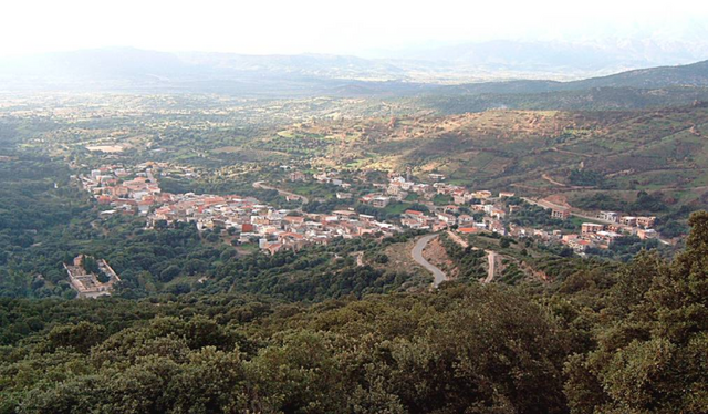
Urzulei (Urzulei)
%20-%202016.svg)
- Italian comune
 Hiking in Urzulei
Urzulei is a picturesque town located in the heart of Sardinia, Italy, and it’s known for its stunning natural landscapes, rich history, and various hiking trails that attract outdoor enthusiasts. Here are some key aspects of hiking in and around Urzulei:
Scenic Trails
-
Su Barchile and Gennargentu National Park: This area is characterized by dramatic granite cliffs, deep valleys, and lush vegetation. There are several trails that offer breathtaking views and varied terrain, suitable for both novice and experienced hikers.
-
Cala Gonone Trails: Nearby, you'll find trails leading to the coastline with stunning views of the Mediterranean Sea. The trek to Cala Luna is a popular route, providing both beach and scenic mountain experiences.
-
Old Sheep Trails: Some trails follow historical paths used by shepherds, offering insight into the region's pastoral history while allowing hikers to explore the unique Sardinian landscape.
Difficulty Levels
Hiking trails in Urzulei range from easy walks suitable for families to challenging treks that require advanced fitness and skills. It's important to choose trails that match your fitness level and experience.
Flora and Fauna
As you hike, you may encounter diverse wildlife, including various bird species and endemic plants. The region is known for its Mediterranean flora, which provides a beautiful backdrop for your hikes.
Practical Tips
- Preparation: Ensure you have appropriate hiking gear, plenty of water, and snacks. Hiking boots are recommended due to the rocky terrain.
- Weather: The best time for hiking in Urzulei is during the spring and autumn months when temperatures are milder. Summer can be very hot, so early morning hikes are advisable.
- Local Guides: Consider hiring a local guide for more challenging trails or to gain insight into the region’s natural history and cultural significance.
Cultural Aspects
Hiking in Urzulei also offers an opportunity to experience the rich local culture. You can visit ancient sites, traditional farms, and sample local Sardinian cuisine in nearby towns after your hike.
Whether you’re looking for a serene nature walk or a challenging hike, Urzulei provides an array of options that cater to every hiker’s preference. Enjoy your adventure in this beautiful part of Sardinia!
- Country:

- Postal Code: 08040
- Local Dialing Code: 0782
- Licence Plate Code: NU
- Coordinates: 40° 5' 35" N, 9° 30' 27" E


- GPS tracks (wikiloc): [Link]
- AboveSeaLevel: 511 м m
- Area: 129.64 sq km
- Population: 1215
- Web site: http://www.comunediurzulei.it
- Wikipedia en: wiki(en)
- Wikipedia: wiki(it)
- Wikidata storage: Wikidata: Q340614
- Wikipedia Commons Category: [Link]
- Freebase ID: [/m/0gqww9]
- Freebase ID: [/m/0gqww9]
- GeoNames ID: Alt: [6537884]
- GeoNames ID: Alt: [6537884]
- VIAF ID: Alt: [309645026]
- VIAF ID: Alt: [309645026]
- OSM relation ID: [40281]
- OSM relation ID: [40281]
- GND ID: Alt: [1054049203]
- GND ID: Alt: [1054049203]
- ISTAT ID: 091099
- ISTAT ID: 091099
- Italian cadastre code: L506
- Italian cadastre code: L506
Shares border with regions:


Dorgali
- Italian comune
Hiking in Dorgali
Dorgali is a picturesque town located on the eastern coast of Sardinia, Italy, surrounded by stunning natural landscapes that are perfect for hiking enthusiasts. The area is characterized by rugged mountains, limestone cliffs, dense forests, and pristine coastline, making it an ideal destination for outdoor adventures....
- Country:
- Postal Code: 08022
- Local Dialing Code: 0784
- Licence Plate Code: NU
- Coordinates: 40° 17' 30" N, 9° 35' 15" E
- GPS tracks (wikiloc): [Link]
- AboveSeaLevel: 400 м m
- Area: 226.54 sq km
- Population: 8596
- Web site: [Link]


Orgosolo
- Italian comune
Hiking in Orgosolo
Orgosolo, a picturesque village located in the mountains of Sardinia, Italy, offers a fantastic hiking experience for outdoor enthusiasts. The area is renowned for its rugged terrain, dramatic landscapes, and rich cultural heritage. Here are some key points to consider when planning a hiking trip in Orgosolo:...
- Country:
- Postal Code: 08027
- Local Dialing Code: 0784
- Licence Plate Code: NU
- Coordinates: 40° 12' 17" N, 9° 21' 9" E
- GPS tracks (wikiloc): [Link]
- AboveSeaLevel: 620 м m
- Area: 222.6 sq km
- Population: 4176
- Web site: [Link]


Baunei
- Italian comune
Hiking in Baunei
Baunei, located on the eastern coast of Sardinia, Italy, is a fantastic destination for hiking enthusiasts. It offers stunning landscapes, including dramatic cliffs, lush valleys, and breathtaking sea views. Here are some highlights and popular trails to consider when hiking in Baunei:...
- Country:
- Postal Code: 08040
- Local Dialing Code: 0782
- Licence Plate Code: NU
- Coordinates: 40° 1' 51" N, 9° 39' 52" E
- GPS tracks (wikiloc): [Link]
- AboveSeaLevel: 480 м m
- Area: 211.9 sq km
- Population: 3602
- Web site: [Link]
Talana
- Italian comune
Hiking in Talana
Talana is a beautiful destination for hiking enthusiasts, offering stunning landscapes and a variety of trails. While specific details about Talana can vary depending on the exact location you’re referring to, one well-known area is the Talana Hill in South Africa, which is significant both historically and naturally. Here’s an overview of what you can generally expect when hiking in Talana or similar natural areas:...
- Country:
- Postal Code: 08040
- Local Dialing Code: 0782
- Licence Plate Code: NU
- Coordinates: 40° 2' 33" N, 9° 29' 49" E
- GPS tracks (wikiloc): [Link]
- AboveSeaLevel: 682 м m
- Area: 118.68 sq km
- Population: 1013
- Web site: [Link]

Triei
- Italian comune
Hiking in Triei
Triei is a small village in the province of Trentino, Italy, and is surrounded by stunning natural landscapes, making it a great spot for hiking enthusiasts. The area is characterized by its beautiful mountains, lush valleys, and picturesque trails that cater to various skill levels....
- Country:
- Postal Code: 08040
- Local Dialing Code: 0782
- Licence Plate Code: NU
- Coordinates: 40° 2' 10" N, 9° 38' 26" E
- GPS tracks (wikiloc): [Link]
- AboveSeaLevel: 140 м m
- Area: 32.98 sq km
- Population: 1132
- Web site: [Link]