Bellefontaine (Bellefontaine)

- commune in Jura, France
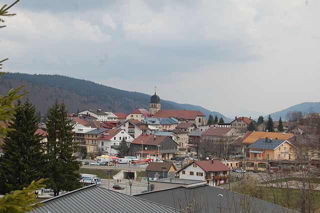
 Hiking in Bellefontaine
Bellefontaine is a picturesque village located in the Jura region of France, known for its stunning natural landscapes, rolling hills, and rich outdoor recreational opportunities. The Jura Mountains offer a fantastic environment for hiking enthusiasts, with a variety of trails suitable for all levels, from easy walks to more challenging hikes.
Hiking Trails in Bellefontaine:
-
Le Sentier des Lacs: This trail takes you on a scenic route around several lakes, providing stunning views and a chance to observe local wildlife. The terrain is relatively easy, making it suitable for families and beginners.
-
Monts Jura Trails: There are numerous hiking paths that lead to different summits within the Jura Mountains, offering breathtaking panoramic views. Trails may vary in difficulty, so be sure to choose one that matches your skill level.
-
Nature Reserves: The surrounding areas boast several nature reserves with well-marked trails. The Parc Naturel Régional du Haut-Jura is a great place to explore the diverse flora and fauna while enjoying well-maintained paths.
-
Historical Trails: Some hikes incorporate historical aspects, taking you past ancient sites, traditional farmhouses, and beautiful landscapes that tell the story of the region's culture and heritage.
Tips for Hiking in Bellefontaine:
- Map and Navigation: Always carry a good local map or GPS device, as some trails may be less marked.
- Weather Conditions: The weather in the Jura can change rapidly, so check forecasts and be prepared for varying conditions.
- Gear Up: Wear appropriate hiking footwear and clothing suitable for the terrain and weather. Sturdy boots and layered clothing are advisable.
- Hydration and Snacks: Bring enough water and snacks, especially for longer hikes, as amenities may be limited on some trails.
- Respect Nature: Follow Leave No Trace principles; stay on marked trails, pack out what you pack in, and respect wildlife.
Best Time to Hike:
The best time for hiking in Bellefontaine is typically from late spring to early autumn (May to October), when the weather is milder and the trails are more accessible. In winter, while cross-country skiing is popular, hiking may be less practical due to snow coverage.
Overall, Bellefontaine offers a beautiful setting for hiking, with trails that showcase the natural beauty and cultural richness of the Jura region. Enjoy your time exploring the great outdoors!
- Country:

- Postal Code: 39400
- Coordinates: 46° 33' 25" N, 6° 3' 56" E


- GPS tracks (wikiloc): [Link]
- Area: 24.71 sq km
- Population: 542
- Wikipedia en: wiki(en)
- Wikipedia: wiki(fr)
- Wikidata storage: Wikidata: Q741837
- Wikipedia Commons Category: [Link]
- Freebase ID: [/m/03mhslg]
- GeoNames ID: Alt: [6448785]
- SIREN number: [213900475]
- BnF ID: [152584128]
- INSEE municipality code: 39047
Shares border with regions:


Morbier
- commune in Jura, France
Hiking in Morbier
Morbier, located in the Jura Mountains of France, is a fantastic area for hiking enthusiasts, offering stunning landscapes, diverse trails, and rich natural beauty. Here are some key highlights about hiking in Morbier:...
- Country:
- Postal Code: 39400
- Coordinates: 46° 32' 13" N, 6° 1' 0" E
- GPS tracks (wikiloc): [Link]
- Area: 41.58 sq km
- Population: 2324
- Web site: [Link]

Les Rousses
- commune in Jura, France
Hiking in Les Rousses
Les Rousses is a delightful destination for hiking enthusiasts, located in the Jura Mountains of France, near the Swiss border. The region is characterized by its stunning landscapes, rolling hills, dense forests, and picturesque alpine scenery. Here are some highlights and considerations for hiking in Les Rousses:...
- Country:
- Postal Code: 39220
- Coordinates: 46° 29' 9" N, 6° 3' 42" E
- GPS tracks (wikiloc): [Link]
- AboveSeaLevel: 1160 м m
- Area: 38 sq km
- Population: 3410
- Web site: [Link]


Bois-d'Amont
- commune in Jura, France
Hiking in Bois-d'Amont
Bois-d'Amont is a charming village located in the Jura region of France, known for its stunning natural landscapes, diverse flora and fauna, and outdoor recreational activities, especially hiking. Here are some key points about hiking in Bois-d'Amont:...
- Country:
- Postal Code: 39220
- Coordinates: 46° 32' 8" N, 6° 8' 21" E
- GPS tracks (wikiloc): [Link]
- Area: 12.06 sq km
- Population: 1693
- Web site: [Link]


Chapelle-des-Bois
- commune in Doubs, France
Hiking in Chapelle-des-Bois
Chapelle-des-Bois is a charming village located in the Jura Mountains of France, known for its beautiful landscapes and outdoor recreational opportunities. Hiking in this area offers a variety of trails suitable for different skill levels, allowing hikers to immerse themselves in nature and enjoy the stunning scenery....
- Country:
- Postal Code: 25240
- Coordinates: 46° 35' 54" N, 6° 6' 52" E
- GPS tracks (wikiloc): [Link]
- Area: 39.69 sq km
- Population: 255