
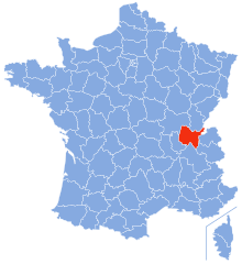
Jura (Jura)
.svg)

- French department
 Hiking in Jura
Hiking in the Jura department, located in the Bourgogne-Franche-Comté region of eastern France, presents a remarkable opportunity to explore stunning natural landscapes, rich biodiversity, and charming villages. The Jura mountain range, characterized by its rolling hills, dense forests, and picturesque lakes, offers diverse hiking trails suitable for all levels of hikers.
Key Features of Hiking in Jura:
-
Scenic Trails: The Jura boasts numerous well-marked hiking trails that cater to different skill levels. Popular trails include:
- The "Sentier des Chutes": This trail takes you along waterfalls and offers beautiful views of the surrounding countryside.
- The "Tour des Lacs": A circular route that covers several of the Jura's stunning lakes, including Lake Chalain and Lake Clairvaux.
-
Natural Attractions: The region is renowned for its stunning landscapes, including:
- Lakes: The Jura has numerous lakes perfect for hiking around, such as Lake Vouglans and the aforementioned lakes.
- Forests: Lush woodlands provide shade and a chance to encounter diverse wildlife, from deer to a variety of bird species.
-
Cultural Sites: Along the hiking trails, you can discover charming villages like Baume-les-Messieurs, known for its historical architecture and proximity to the stunning Baume Caves, or Arbois, famous for its wine and picturesque vineyards.
-
Seasonal Hiking: Each season presents a unique experience:
- Spring and summer offer vibrant flora and fauna, perfect for nature photography.
- Autumn brings stunning fall colors, making for a breathtaking backdrop.
- In winter, certain trails can be used for snowshoeing, offering a different kind of adventure.
-
Wildlife and Flora: The Jura is home to diverse wildlife, making it a great spot for birdwatching and observing other wildlife species. You'll also encounter a variety of plant species, particularly in the protected areas.
-
Additional Activities: Besides hiking, the Jura offers mountain biking, kayaking on its lakes, and winter sports in the snow-covered regions.
Tips for Hiking in Jura:
- Maps and Resources: Consider obtaining a detailed trail map or using a hiking app to help navigate the trails.
- Weather: Always check the weather conditions before setting out, as they can change rapidly, especially in mountainous areas.
- Preparation: Wear proper hiking boots, carry enough water, and have snacks on hand. Starting early in the day can help you avoid crowds and heat.
- Local Regulations: Stay on marked trails to protect the environment and follow local regulations regarding wildlife and camping.
Overall, hiking in the Jura is an enriching experience that combines natural beauty with cultural heritage, making it a must-visit destination for outdoor enthusiasts.
- Country:

- Capital: Lons-le-Saunier
- Coordinates: 46° 40' 31" N, 5° 33' 16" E


- GPS tracks (wikiloc): [Link]
- Area: 4999 sq km
- Population: 260587
- Web site: http://www.jura.pref.gouv.fr/
- Wikipedia en: wiki(en)
- Wikipedia: wiki(fr)
- Wikidata storage: Wikidata: Q3120
- Wikipedia Commons Gallery: [Link]
- Wikipedia Commons Category: [Link]
- Wikipedia Commons Maps Category: [Link]
- Freebase ID: [/m/0mh6s]
- GeoNames ID: Alt: [3012051]
- SIREN number: [223900010]
- BnF ID: [11936964n]
- VIAF ID: Alt: [234191213]
- OSM relation ID: [7460]
- GND ID: Alt: [4126127-6]
- archINFORM location ID: [1691]
- Library of Congress authority ID: Alt: [n81141839]
- MusicBrainz area ID: [e834a1e2-e967-4c89-8306-5f22d6376ab4]
- TGN ID: [7002956]
- SUDOC authorities ID: [027296946]
- Encyclopædia Britannica Online ID: [place/Jura-department-France]
- Gran Enciclopèdia Catalana ID: [0035139]
- NUTS code: [FR432]
- FAST ID: [1216997]
- NE.se ID: [jura-(departement-frankrike)]
- INSEE department code: [39]
- BAV ID: [ADV12666163]
- SIRET number: Alt: [22390001000362]
- ISO 3166-2 code: FR-39
Includes regions:
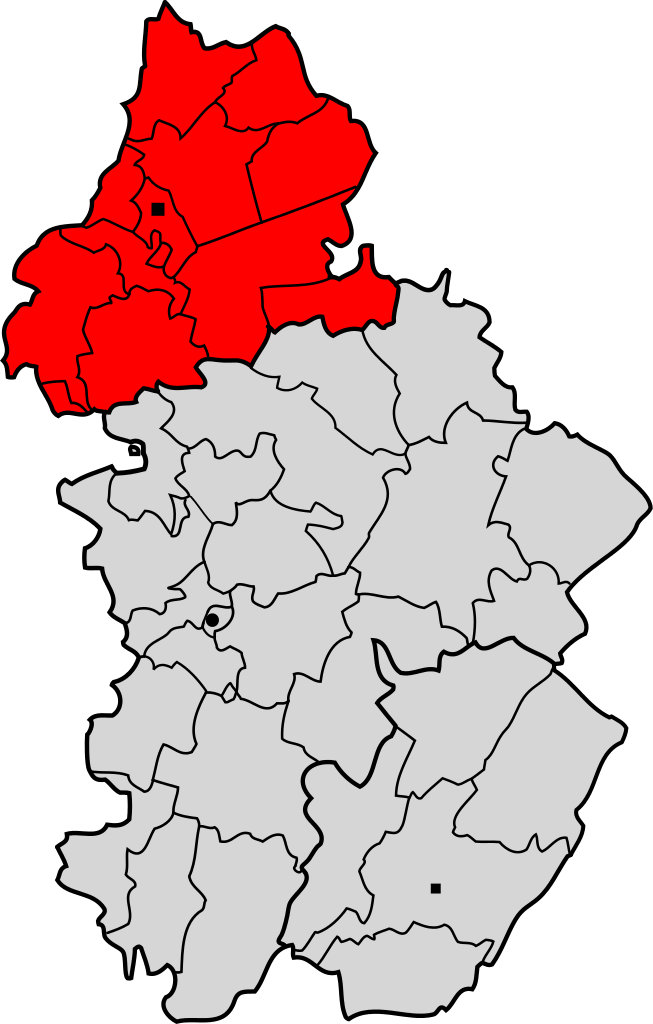
arrondissement of Lons-le-Saunier
- arrondissement of France
Hiking in arrondissement of Lons-le-Saunier
The Arrondissement of Lons-le-Saunier, located in the Jura department of France, offers a wealth of hiking opportunities set against a backdrop of stunning natural scenery, rolling hills, and a rich cultural landscape. This area is part of the Jura Mountains, which are known for their diverse landscapes that include forests, lakes, rivers, and charming villages....
- Country:
- Capital: Lons-le-Saunier
- Coordinates: 46° 45' 0" N, 5° 45' 0" E
- GPS tracks (wikiloc): [Link]
- Area: 2817 sq km
- Population: 104567


Lombard
- commune in Jura, France
Hiking in Lombard
Hiking in the Lombard region of the Jura Mountains offers stunning views, lush forests, and a diverse range of trails suitable for various skill levels. The Jura mountain range stretches along the border between France and Switzerland, and Lombard is typically associated with the more picturesque and accessible areas for hikers....
- Country:
- Postal Code: 39230
- Coordinates: 46° 47' 8" N, 5° 30' 27" E
- GPS tracks (wikiloc): [Link]
- Area: 5.41 sq km
- Population: 208

arrondissement of Saint-Claude
- arrondissement of France
Hiking in arrondissement of Saint-Claude
The Arrondissement of Saint-Claude, located in the Jura department in the Bourgogne-Franche-Comté region of France, is renowned for its beautiful landscapes and opportunities for outdoor activities, especially hiking. The area is characterized by its rolling hills, forests, lakes, and impressive geological formations, making it a perfect destination for nature enthusiasts....
- Country:
- Capital: Saint-Claude
- Coordinates: 46° 30' 0" N, 5° 50' 0" E
- GPS tracks (wikiloc): [Link]
- Population: 49969
arrondissement of Dole
- arrondissement of France
Hiking in arrondissement of Dole
The Arrondissement of Dole, located in the Jura department in the Bourgogne-Franche-Comté region of eastern France, offers a variety of hiking opportunities that showcase the stunning natural landscape of the Jura Mountains. Here are some highlights for hiking in this area:...
- Country:
- Capital: Dole
- Coordinates: 47° 5' 0" N, 5° 30' 0" E
- GPS tracks (wikiloc): [Link]
- Area: 1180 sq km
- Population: 106051
Shares border with regions:


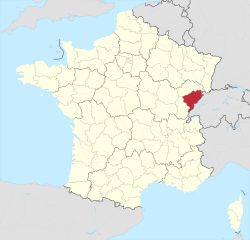
Haute-Saône
- French department
Hiking in Haute-Saône
Haute-Saône, located in the Bourgogne-Franche-Comté region of eastern France, offers a variety of beautiful hiking opportunities thanks to its diverse landscapes, which include rolling hills, forests, rivers, and charming villages. Here are some highlights of hiking in Haute-Saône:...
- Country:
- Capital: Vesoul
- Coordinates: 47° 35' 0" N, 6° 0' 0" E
- GPS tracks (wikiloc): [Link]
- Area: 5360 sq km
- Population: 237706
- Web site: [Link]


Saône-et-Loire
- French department
Hiking in Saône-et-Loire
Saône-et-Loire is a beautiful department in the Bourgogne-Franche-Comté region of France, known for its rich history, stunning landscapes, and diverse trails suitable for all levels of hikers. Here’s what you can expect when hiking in this picturesque region:...
- Country:
- Capital: Mâcon
- Coordinates: 46° 40' 0" N, 4° 42' 0" E
- GPS tracks (wikiloc): [Link]
- Area: 8575 sq km
- Population: 555408
- Web site: [Link]


Canton of Vaud
- canton of Switzerland
Hiking in Canton of Vaud
The Canton of Vaud, located in the French-speaking part of Switzerland, is a fantastic destination for hiking enthusiasts. It offers a diverse range of landscapes, from picturesque lakeside trails along Lake Geneva to challenging mountain hikes in the Alps. Here are some highlights of hiking in this beautiful region:...
- Country:

- Capital: Lausanne
- Licence Plate Code: VD
- Coordinates: 46° 37' 0" N, 6° 33' 0" E
- GPS tracks (wikiloc): [Link]
- AboveSeaLevel: 495 м m
- Area: 3212 sq km
- Web site: [Link]

Ain
- French département
Hiking in Ain
Certainly! Ain, a department located in the Auvergne-Rhône-Alpes region of France, offers a diverse range of hiking opportunities, from gentle trails suited for families to more challenging hikes for experienced trekkers. Here are some highlights about hiking in Ain:...
- Country:
- Capital: Bourg-en-Bresse
- Coordinates: 46° 5' 0" N, 5° 20' 0" E
- GPS tracks (wikiloc): [Link]
- Area: 5762 sq km
- Population: 631877
- Web site: [Link]

Côte-d’Or
- French department
- Country:
- Capital: Dijon
- Coordinates: 47° 25' 0" N, 4° 50' 0" E
- GPS tracks (wikiloc): [Link]
- Area: 8763 sq km
- Population: 533147
- Web site: [Link]

Doubs
- French department with 3 arrondissements
Hiking in Doubs
Hiking in the Doubs region, located in eastern France, offers stunning landscapes and a rich natural heritage. The Doubs department is known for its rugged terrain, deep valleys, and diverse ecosystems, making it a wonderful destination for outdoor enthusiasts. Here are some highlights and recommendations for hiking in the area:...
- Country:
- Capital: Besançon
- Coordinates: 47° 10' 0" N, 6° 25' 0" E
- GPS tracks (wikiloc): [Link]
- Area: 5234 sq km
- Population: 536959
- Web site: [Link]