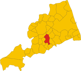
Belmonte Piceno (Belmonte Piceno)
.svg)
- Italian comune
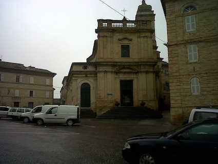
 Hiking in Belmonte Piceno
Belmonte Piceno is a charming village located in the Marche region of Italy, known for its beautiful landscapes and rich history. Hiking in and around Belmonte Piceno offers a wonderful way to explore the natural beauty and cultural heritage of the area. Here are some highlights of hiking in this region:
Trails and Routes
-
Local Trails: There are several well-marked trails around Belmonte Piceno that provide varying levels of hiking difficulty. Many of these trails take you through picturesque landscapes, including rolling hills, vineyards, and olive groves.
-
Nature Reserves: The nearby Sibillini Mountains National Park offers more challenging hikes with stunning views of the Apennines. You can explore trails that lead to high peaks, scenic ridges, and pristine lakes.
-
Historical Paths: Some trails may also take you through ancient villages, offering a glimpse into the history and architecture of the region. You can find old churches, castles, and fortifications along the way.
Tips for Hiking in Belmonte Piceno
-
Seasonal Considerations: Consider the time of year you plan to hike. Spring and fall typically offer the best weather, while summer can be hot, and winter conditions may make higher elevation trails challenging.
-
Preparation: Make sure to bring plenty of water, snacks, and appropriate gear. Given the rural setting, it’s also a good idea to inform someone of your plans before heading out.
-
Local Guides: If you’re unsure about the best routes or want to know more about the area, consider hiring a local guide. They can provide valuable insights and enhance your hiking experience.
-
Cultural Respect: When hiking through local villages, be respectful of the residents and their properties, especially in less touristy areas.
Wildlife and Flora
The landscapes around Belmonte Piceno are home to diverse flora and fauna. As you hike, you may encounter various bird species, wildflowers, and even some local wildlife. Early spring or late spring is a particularly vibrant time with wildflowers in full bloom.
Conclusion
Hiking in Belmonte Piceno offers a mix of natural beauty, cultural richness, and outdoor adventure. Whether you're a seasoned hiker or a casual walker, exploring this beautiful part of Marche can be a memorable experience filled with breathtaking views and historical discoveries.
- Country:

- Postal Code: 63838
- Local Dialing Code: 0734
- Licence Plate Code: FM
- Coordinates: 43° 5' 29" N, 13° 32' 20" E


- GPS tracks (wikiloc): [Link]
- AboveSeaLevel: 312 м m
- Area: 10.53 sq km
- Population: 624
- Web site: http://www.comunebelmontepiceno.it/
- Wikipedia en: wiki(en)
- Wikipedia: wiki(it)
- Wikidata storage: Wikidata: Q59224
- Wikipedia Commons Category: [Link]
- Freebase ID: [/m/0gl7mj]
- GeoNames ID: Alt: [6541070]
- VIAF ID: Alt: [2913150203818203250004]
- OSM relation ID: [42313]
- GND ID: Alt: [1137731869]
- TGN ID: [7056808]
- Google Maps Customer ID: [7058237724678349395]
- ISTAT ID: 109003
- Italian cadastre code: A760
Shares border with regions:


Fermo
- Italian comune
Hiking in Fermo
Fermo, located in the Marche region of Italy, offers a variety of hiking opportunities that showcase its stunning landscapes, historical sites, and charming countryside. Here are some highlights and tips for hiking in and around Fermo:...
- Country:
- Postal Code: 63900
- Local Dialing Code: 0734
- Licence Plate Code: FM
- Coordinates: 43° 9' 38" N, 13° 43' 5" E
- GPS tracks (wikiloc): [Link]
- AboveSeaLevel: 319 м m
- Area: 124.53 sq km
- Population: 37238
- Web site: [Link]


Falerone
- Italian comune
Hiking in Falerone
Falerone, located in the Le Marche region of Italy, is a picturesque town that offers a range of hiking opportunities, particularly suited for those who appreciate a mix of natural beauty, history, and culture. The surrounding countryside is characterized by rolling hills, vineyards, and olive groves, making it a wonderful destination for outdoor enthusiasts....
- Country:
- Postal Code: 63837
- Local Dialing Code: 0734
- Licence Plate Code: FM
- Coordinates: 43° 6' 28" N, 13° 28' 24" E
- GPS tracks (wikiloc): [Link]
- AboveSeaLevel: 432 м m
- Area: 24.61 sq km
- Population: 3330
- Web site: [Link]

Grottazzolina
- Italian comune
Hiking in Grottazzolina
Grottazzolina is a charming town located in the Marche region of Italy, known for its beautiful landscapes and natural scenery, making it a great destination for hiking enthusiasts. The area offers various trails that can cater to different levels of hikers. Here are some highlights about hiking in and around Grottazzolina:...
- Country:
- Postal Code: 63844
- Local Dialing Code: 0734
- Licence Plate Code: FM
- Coordinates: 43° 6' 40" N, 13° 36' 3" E
- GPS tracks (wikiloc): [Link]
- AboveSeaLevel: 227 м m
- Area: 9.26 sq km
- Population: 3333
- Web site: [Link]
Monsampietro Morico
- Italian comune
Hiking in Monsampietro Morico
Monsampietro Morico is a small, picturesque village located in the Marche region of Italy, known for its beautiful landscapes and hiking opportunities. The surrounding area is characterized by rolling hills, lush forests, and stunning views of the Apennine mountains, making it a great destination for hiking enthusiasts....
- Country:
- Postal Code: 63842
- Local Dialing Code: 0734
- Licence Plate Code: FM
- Coordinates: 43° 4' 3" N, 13° 33' 22" E
- GPS tracks (wikiloc): [Link]
- AboveSeaLevel: 289 м m
- Area: 9.76 sq km
- Population: 637
- Web site: [Link]


Montegiorgio
- Italian comune
Hiking in Montegiorgio
Montegiorgio, located in the Marche region of Italy, is a charming town that offers a variety of hiking opportunities amidst beautiful landscapes, rolling hills, and scenic views. Here are some key points to consider when hiking in and around Montegiorgio:...
- Country:
- Postal Code: 63833
- Local Dialing Code: 0734
- Licence Plate Code: FM
- Coordinates: 43° 7' 51" N, 13° 32' 13" E
- GPS tracks (wikiloc): [Link]
- AboveSeaLevel: 411 м m
- Area: 47.45 sq km
- Population: 6723
- Web site: [Link]
Monteleone di Fermo
- Italian comune
Hiking in Monteleone di Fermo
Monteleone di Fermo is a charming village located in the Marche region of Italy, surrounded by beautiful landscapes ideal for hiking enthusiasts. Here’s an overview of what you can expect when hiking in this area:...
- Country:
- Postal Code: 63841
- Local Dialing Code: 0734
- Licence Plate Code: FM
- Coordinates: 43° 2' 51" N, 13° 31' 43" E
- GPS tracks (wikiloc): [Link]
- AboveSeaLevel: 427 м m
- Area: 8.21 sq km
- Population: 381
- Web site: [Link]

Montottone
- Italian comune
Hiking in Montottone
Montottone is a charming hilltop village located in the Marche region of Italy. Known for its picturesque landscapes, rich history, and beautiful architecture, it offers a variety of hiking opportunities for outdoor enthusiasts. Here are some aspects to consider if you're planning to hike in and around Montottone:...
- Country:
- Postal Code: 63843
- Local Dialing Code: 0734
- Licence Plate Code: FM
- Coordinates: 43° 3' 43" N, 13° 35' 5" E
- GPS tracks (wikiloc): [Link]
- AboveSeaLevel: 277 м m
- Area: 16.38 sq km
- Population: 978
- Web site: [Link]


Servigliano
- Italian comune
Hiking in Servigliano
Servigliano is a charming town located in the Marche region of Italy, surrounded by picturesque landscapes that make it an excellent destination for hiking enthusiasts. Here are some aspects to consider if you're thinking about hiking in and around Servigliano:...
- Country:
- Postal Code: 63839
- Local Dialing Code: 0734
- Licence Plate Code: FM
- Coordinates: 43° 4' 51" N, 13° 29' 31" E
- GPS tracks (wikiloc): [Link]
- AboveSeaLevel: 216 м m
- Area: 18.49 sq km
- Population: 2267
- Web site: [Link]