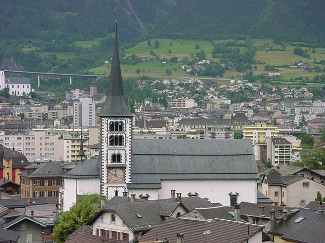
Betten (Betten VS)

- former municipality of Switzerland
 Hiking in Betten
Betten is a picturesque village located in the Valais region of Switzerland, known for its stunning alpine scenery and outdoor activities, including hiking. Here are some key points about hiking in Betten:
Hiking Trails
- Variety of Trails: The area offers a variety of hiking trails suitable for different skill levels, from easy walks to challenging mountain hikes.
- Scenic Views: Many trails provide breathtaking views of the surrounding mountains, valleys, and the Rhone River.
- Accessibility: Some hikes start directly from Betten, while others may require a short drive or a cable car ride to reach the trailheads.
Popular Hiking Routes
- Betten to Bettmeralp: A scenic hike that takes you from Betten to the neighboring village of Bettmeralp, where you can enjoy stunning panoramic views of the Aletsch Glacier, a UNESCO World Heritage site.
- High Alpine Trails: For experienced hikers, there are higher elevation trails that offer a more challenging experience, including routes that take you through rugged terrain and offer the chance to see local wildlife.
Seasons
- Summer: The best time for hiking in Betten is during the summer months (June to September), when the weather is generally mild and the trails are accessible.
- Autumn: Hiking in autumn can offer beautiful fall foliage, but be prepared for cooler temperatures.
- Winter: Winter hiking can be enjoyed with appropriate equipment, but always check current conditions and trail availability.
Tips for Hiking in Betten
- Maps and Guides: It’s recommended to carry a map or guidebook for the trails in the area. Local tourist information centers can provide detailed maps and brochures.
- Appropriate Gear: Wear good hiking shoes and layered clothing to adapt to changing weather conditions.
- Safety: Always inform someone about your hiking plans and check the weather forecast before heading out. Carry sufficient water, snacks, and a first aid kit.
Local Amenities
- Accommodation: Betten offers various accommodation options, including hotels and guesthouses. Many places provide easy access to hiking trails.
- Dining: After a day of hiking, you can enjoy local Swiss cuisine at restaurants in the village or on the trails at mountain huts.
Whether you’re looking for a leisurely stroll or an ambitious trek, Betten provides a beautiful backdrop for outdoor adventure. Remember to respect the natural environment and follow local hiking guidelines for a safe and enjoyable experience!
- Country:

- Postal Code: 3991
- Local Dialing Code: 027
- Licence Plate Code: VS
- Coordinates: 46° 22' 0" N, 8° 4' 0" E


- GPS tracks (wikiloc): [Link]
- AboveSeaLevel: 1192 м m
- Area: 26.4 sq km
- Web site: http://gemeinde.bettmeralp.ch
- Wikipedia en: wiki(en)
- Wikipedia: wiki(de)
- Wikidata storage: Wikidata: Q68474
- Wikipedia Commons Category: [Link]
- Freebase ID: [/m/0h6c63]
- GeoNames ID: Alt: [2661535]
- VIAF ID: Alt: [242130823]
- OSM relation ID: [1685274]
- HDS ID: [2746]
- Swiss municipality code: [6171]
Shares border with regions:

Naters
- municipality in the canton of Valais, Switzerland
Hiking in Naters
Naters is a picturesque municipality in the Valais region of Switzerland, located near the popular tourist destination of Brig. The area offers a variety of hiking opportunities, suitable for different skill levels and preferences. Here are some highlights and tips for hiking in Naters:...
- Country:
- Postal Code: 3904
- Local Dialing Code: 027
- Licence Plate Code: VS
- Coordinates: 46° 19' 25" N, 7° 59' 19" E
- GPS tracks (wikiloc): [Link]
- AboveSeaLevel: 2774 м m
- Area: 101.26 sq km
- Population: 9983
- Web site: [Link]


Grengiols
- municipality in Switzerland
Hiking in Grengiols
Grengiols is a charming village located in the Valais region of Switzerland, known for its stunning landscapes and diverse hiking opportunities. Nestled in the mountains, it offers a unique blend of natural beauty, traditional Swiss architecture, and a peaceful atmosphere. Here are some key points about hiking in Grengiols:...
- Country:
- Postal Code: 3993
- Local Dialing Code: 027
- Licence Plate Code: VS
- Coordinates: 46° 22' 0" N, 8° 6' 0" E
- GPS tracks (wikiloc): [Link]
- AboveSeaLevel: 984 м m
- Area: 58.46 sq km
- Population: 432
- Web site: [Link]


Riederalp
- municipality in Switzerland
Hiking in Riederalp
Riederalp, located in the Swiss Alps in the Valais canton, is a fantastic destination for hikers of all skill levels. Nestled at an elevation of about 1,900 meters, it offers stunning views of the surrounding mountains, including the iconic Matterhorn and the Aletsch Glacier, which is the largest glacier in the Alps and a UNESCO World Heritage site....
- Country:
- Postal Code: 3987
- Local Dialing Code: 027
- Licence Plate Code: VS
- Coordinates: 46° 23' 0" N, 8° 2' 0" E
- GPS tracks (wikiloc): [Link]
- AboveSeaLevel: 1905 м m
- Area: 21.04 sq km
- Population: 481
- Web site: [Link]
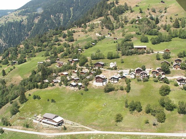

Martisberg
- former municipality of Switzerland
Hiking in Martisberg
Martisberg is a lovely area for hiking, located in the Sierra Nevada region of California, near Lake Tahoe. This area features a mix of beautiful scenery, diverse wildlife, and various trails that cater to different skill levels. Here are some key points to consider when planning your hike in Martisberg:...
- Country:
- Postal Code: 3994
- Local Dialing Code: 027
- Licence Plate Code: VS
- Coordinates: 46° 23' 0" N, 8° 5' 0" E
- GPS tracks (wikiloc): [Link]
- AboveSeaLevel: 1367 м m
- Area: 3.0 sq km


Lax
- municipality in Switzerland
Hiking in Lax
Lax, Switzerland, is a beautiful village located in the Valais region, renowned for its stunning alpine scenery and numerous hiking opportunities. Here are some key points about hiking in and around Lax:...
- Country:
- Postal Code: 3994
- Local Dialing Code: 027
- Licence Plate Code: VS
- Coordinates: 46° 23' 0" N, 8° 7' 0" E
- GPS tracks (wikiloc): [Link]
- AboveSeaLevel: 1045 м m
- Area: 5.02 sq km
- Population: 308
- Web site: [Link]


Fieschertal
- municipality in Switzerland
Hiking in Fieschertal
Fieschertal, located in the Swiss Alps in the municipality of Fiesch, is a picturesque destination for hiking enthusiasts. The region is renowned for its stunning landscapes, lush valleys, and breathtaking mountain views, making it an excellent choice for hikers of all levels....
- Country:
- Postal Code: 3984
- Local Dialing Code: 027
- Licence Plate Code: VS
- Coordinates: 46° 30' 0" N, 8° 8' 0" E
- GPS tracks (wikiloc): [Link]
- AboveSeaLevel: 1108 м m
- Area: 172.96 sq km
- Population: 334
- Web site: [Link]