
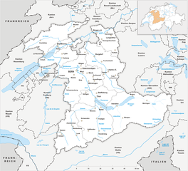
Canton of Valais (Kanton Wallis)


- canton of Switzerland
 Hiking in Canton of Valais
The Canton of Valais, located in southwestern Switzerland, is a fantastic destination for hiking enthusiasts. Famous for its stunning landscapes dominated by the Alps, the region offers a wide variety of trails suitable for all levels of hikers. Here are some key points to know about hiking in Valais:
1.
- Beginner to Expert: The hiking trails range from easy walks around picturesque villages and valleys to challenging high-altitude hikes that require more experience and fitness.
- Nature and Culture: Many trails lead through beautiful nature reserves, vineyards, and historic villages, allowing hikers to experience both the region's natural beauty and cultural heritage.
2.
- The Valais is home to some iconic peaks, including the Matterhorn and the Dent Blanche. The panoramic views from many trails are breathtaking, especially from higher altitudes.
- Glacial lakes, lush meadows, and rugged mountains create a diverse landscape that changes with the seasons.
3.
- Zermatt: A hub for hiking, Zermatt offers trails like the famous Five Lakes Walk, which provides views of the Matterhorn alongside serene alpine lakes.
- Saas Fee: This area is known for its stunning alpine scenery and offers various trails, including paths that lead to glaciers.
- Verbier: Offers access to extensive walking paths with views of the Alps and the chance to spot local wildlife.
4.
- Trails in Valais are generally well-marked with yellow signs indicating direction and estimated walking times. It’s advisable to carry a good map or use GPS for navigation, especially on less traveled paths.
5.
- Summer (June to September): Ideal for hiking, as the weather is usually warm and trails are accessible.
- Autumn (October): Offers beautiful fall colors, but higher trails may start to get snowy.
- Winter: Some trails are suitable for snowshoeing or winter hiking, but check conditions before heading out.
6.
- Always check the weather forecast before heading out and be prepared for changing conditions.
- Wear appropriate footwear and clothing, and carry enough water, snacks, and safety gear.
- If hiking in challenging areas, consider hiking with a partner or guide.
7.
- Valais has a range of accommodations, from mountain huts to luxury hotels, catering to all budgets. Many villages also have restaurants and shops for supplies.
In summary, hiking in the Canton of Valais is an exceptional experience, with options for all skill levels to enjoy the alpine beauty of this unique part of Switzerland. Whether you’re looking for a day hike or a multi-day trek, you’re sure to find a trail that suits your needs.
- Country:

- Capital: Sion
- Licence Plate Code: VS
- Coordinates: 46° 4' 0" N, 7° 36' 0" E


- GPS tracks (wikiloc): [Link]
- AboveSeaLevel: 512 м m
- Area: 5224.50 sq km
- Web site: https://www.vs.ch
- Wikipedia en: wiki(en)
- Wikipedia: wiki(de)
- Wikidata storage: Wikidata: Q834
- Wikipedia Commons Gallery: [Link]
- Wikipedia Commons Category: [Link]
- Freebase ID: [/m/01c744]
- GeoNames ID: Alt: [2658205]
- BnF ID: [11937449m]
- VIAF ID: Alt: [123749010]
- OSM relation ID: [1686699]
- GND ID: Alt: [4064466-2]
- archINFORM location ID: [3939]
- Library of Congress authority ID: Alt: [n80104828]
- MusicBrainz area ID: [e1384603-3a9e-4427-ac2d-4b8473e8e32c]
- Quora topic ID: [Canton-of-Valais]
- SUDOC authorities ID: [031843530]
- Encyclopædia Britannica Online ID: [place/Valais]
- Encyclopædia Universalis ID: [valais]
- ISNI: Alt: [0000 0001 1543 9866]
- DMOZ ID: Alt: [Regional/Europe/Switzerland/Cantons/Valais/]
- National Library of Israel ID: [000980762]
- NUTS code: [CH012]
- Klexikon article ID: [Wallis]
- Ringgold ID: [127680]
- BabelNet ID: [01258532n]
- Brockhaus Enzyklopädie online ID: [wallis-20]
- STW Thesaurus for Economics ID: [16978-3]
- ISO 3166-2 code: CH-VS
- FIPS 10-4 (countries and regions): SZ22
Includes regions:


Saint-Maurice District
- district of the canton of Valais, Switzerland
Hiking in Saint-Maurice District
The Saint-Maurice District, located in the Valais region of Switzerland, is a stunning area known for its picturesque landscapes, towering mountains, and vibrant hiking trails. Whether you're a seasoned hiker or a beginner, there's something for everyone in this region. Here are some highlights and details to consider when hiking in the Saint-Maurice District:...
- Country:
- Licence Plate Code: VS
- Coordinates: 46° 9' 14" N, 6° 59' 54" E
- GPS tracks (wikiloc): [Link]
- AboveSeaLevel: 2099 м m
- Area: 185.6 sq km
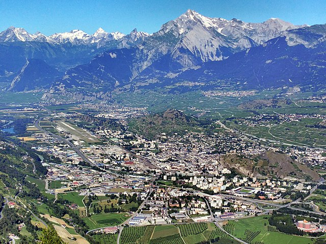

Sion District
- district of the canton of Valais, Switzerland
Hiking in Sion District
The Sion District, located in the heart of Switzerland's Valais canton, is a wonderful destination for hiking enthusiasts. Known for its stunning alpine landscapes, charming villages, and rich cultural heritage, the Sion District offers a variety of hiking trails suitable for different skill levels....
- Country:
- Capital: Sion
- Licence Plate Code: VS
- Coordinates: 46° 14' 0" N, 7° 20' 58" E
- GPS tracks (wikiloc): [Link]
- AboveSeaLevel: 548 м m
- Area: 125.6 sq km


Östlich Raron District
- district of the canton of Valais, Switzerland
Hiking in Östlich Raron District
Östlich Raron, located in the Valais region of Switzerland, offers a unique and beautiful hiking experience characterized by stunning alpine scenery, diverse landscapes, and a variety of trails suitable for different skill levels. Here are some highlights and tips for hiking in this area:...
- Country:
- Capital: Mörel-Filet
- Licence Plate Code: VS
- Coordinates: 46° 20' 0" N, 8° 3' 1" E
- GPS tracks (wikiloc): [Link]
- Area: 127.2 sq km


Hérens District
- district of the canton of Valais, Switzerland
Hiking in Hérens District
The Hérens District, located in the Valais Canton of Switzerland, is known for its stunning landscapes, diverse terrain, and rich cultural heritage, making it a fantastic destination for hiking enthusiasts. Here are some key points to consider when hiking in the Hérens District:...
- Country:
- Capital: Vex
- Licence Plate Code: VS
- Coordinates: 46° 11' 38" N, 7° 25' 26" E
- GPS tracks (wikiloc): [Link]
- AboveSeaLevel: 1098 м m
- Area: 443.5 sq km


Sierre District
- district of the canton of Valais, Switzerland
Hiking in Sierre District
The Sierre District is located in the Valais (Wallis) region of Switzerland, and it's known for its stunning landscapes, diverse terrain, and a variety of hiking trails suitable for all levels of hikers. Here are some key highlights about hiking in the Sierre District:...
- Country:
- Capital: Sierre
- Licence Plate Code: VS
- Coordinates: 46° 16' 14" N, 7° 30' 57" E
- GPS tracks (wikiloc): [Link]
- AboveSeaLevel: 515 м m
- Area: 397.0 sq km
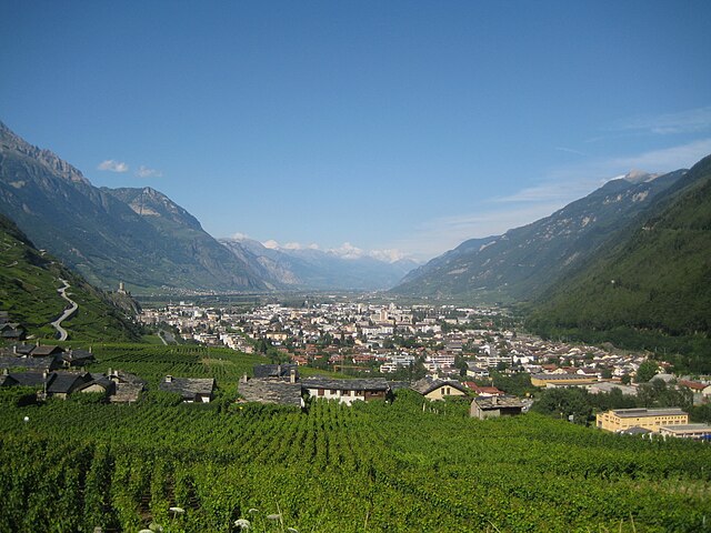

Martigny District
- district of the canton of Valais, Switzerland
Hiking in Martigny District
Hiking in the Martigny District can be a breathtaking experience, as it is located in the Valais region of Switzerland, known for its stunning landscapes, varied terrain, and rich cultural history. Here are some highlights and tips for hiking in this area:...
- Country:
- Capital: Martigny
- Licence Plate Code: VS
- Coordinates: 46° 7' 26" N, 7° 6' 13" E
- GPS tracks (wikiloc): [Link]
- AboveSeaLevel: 458 м m
- Area: 263.5 sq km


Brig District
- district of the canton of Valais, Switzerland
Hiking in Brig District
The Brig District, located in the Valais canton of Switzerland, is a picturesque region known for its stunning landscapes, rich history, and a variety of hiking opportunities. Here’s what you need to know about hiking in this beautiful area:...
- Country:
- Capital: Brig-Glis
- Coordinates: 46° 18' 42" N, 7° 59' 6" E
- GPS tracks (wikiloc): [Link]
- AboveSeaLevel: 1478 м m
- Area: 434.5 sq km


Visp District
- district of the canton of Valais, Switzerland
Hiking in Visp District
The Visp District, located in the Valais canton of Switzerland, is an excellent destination for hiking enthusiasts. Surrounded by stunning Alpine scenery, it offers a variety of trails suitable for different skill levels, from beginners to experienced hikers. Here are some highlights and key points regarding hiking in the Visp District:...
- Country:
- Capital: Visp
- Licence Plate Code: VS
- Coordinates: 46° 17' 0" N, 7° 52' 0" E
- GPS tracks (wikiloc): [Link]
- AboveSeaLevel: 2758 м m
- Area: 863.8 sq km


Entremont District
- district of the canton of Valais, Switzerland
Hiking in Entremont District
The Entremont District, located in the French Alps, is a fantastic destination for hiking enthusiasts, offering stunning landscapes and a variety of trails for all levels of hikers. The region is characterized by its alpine scenery, including majestic mountains, lush valleys, and picturesque villages, making it a great place to explore the natural beauty of the French Alps....
- Country:
- Capital: Sembrancher
- Licence Plate Code: VS
- Coordinates: 46° 3' 42" N, 7° 16' 23" E
- GPS tracks (wikiloc): [Link]
- AboveSeaLevel: 2229 м m
- Area: 633.2 sq km


Monthey District
- district of the canton of Valais, Switzerland
Hiking in Monthey District
The Monthey District, located in the Valais region of Switzerland, is a fantastic destination for hiking enthusiasts. This area, nestled between stunning Alpine landscapes, offers a variety of trails suitable for all skill levels, from beginners to experienced hikers....
- Country:
- Capital: Monthey
- Licence Plate Code: VS
- Coordinates: 46° 16' 14" N, 6° 54' 10" E
- GPS tracks (wikiloc): [Link]
- AboveSeaLevel: 1214 м m
- Area: 255.1 sq km

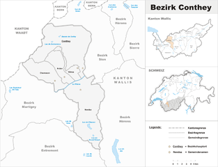
Conthey District
- district of the canton of Valais, Switzerland
Hiking in Conthey District
Conthey District, located in the Canton of Valais in Switzerland, is known for its stunning landscapes, abundant natural beauty, and diverse hiking opportunities. Here are some highlights of hiking in this area:...
- Country:
- Capital: Conthey
- Licence Plate Code: VS
- Coordinates: 46° 12' 17" N, 7° 16' 42" E
- GPS tracks (wikiloc): [Link]
- AboveSeaLevel: 487 м m
- Area: 234.2 sq km

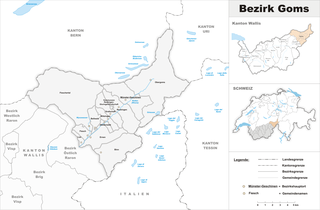
Goms District
- district of the canton of Valais, Switzerland
Hiking in Goms District
Goms District, located in the Valais region of Switzerland, is a stunning destination for hiking enthusiasts. Known for its picturesque landscapes, charming villages, and rich cultural heritage, Goms offers a variety of hiking trails suited for different skill levels....
- Country:
- Capital: Münster-Geschinen
- Licence Plate Code: VS
- Coordinates: 46° 27' 0" N, 8° 18' 0" E
- GPS tracks (wikiloc): [Link]
- AboveSeaLevel: 1407 м m
- Area: 588.3 sq km

Westlich Raron District
- district of the canton of Valais, Switzerland
Hiking in Westlich Raron District
Westlich Raron is a beautiful area located in the Swiss Alps, specifically in the Valais region of Switzerland. It's known for its stunning landscapes, diverse trails, and the picturesque views of the surrounding mountains. Here are some key points to consider if you're planning to hike in this region:...
- Country:
- Capital: Raron
- Licence Plate Code: VS
- Coordinates: 46° 18' 0" N, 8° 48' 0" E
- GPS tracks (wikiloc): [Link]
- Area: 270.87 sq km


Leuk District
- district of the canton of Valais, Switzerland
Hiking in Leuk District
The Leuk District, located in the Valais canton of Switzerland, is a stunning hiking destination known for its diverse landscapes, charming villages, and a variety of trails suitable for all skill levels. Here are some key highlights to consider when planning a hiking trip in this region:...
- Country:
- Capital: Leuk
- Licence Plate Code: VS
- Coordinates: 46° 19' 5" N, 7° 38' 4" E
- GPS tracks (wikiloc): [Link]
- AboveSeaLevel: 957 м m
- Area: 335.9 sq km
Shares border with regions:

canton of Bern
- canton of Switzerland
Hiking in canton of Bern
The Canton of Bern, located in Switzerland, offers some of the most stunning landscapes and diverse trails for hiking enthusiasts. This region boasts a mix of alpine scenery, picturesque villages, and lush valleys, making it an excellent destination for all levels of hikers. Here are some highlights you can expect when hiking in the Canton of Bern:...
- Country:
- Capital: Bern
- Licence Plate Code: BE
- Coordinates: 46° 50' 0" N, 7° 37' 0" E
- GPS tracks (wikiloc): [Link]
- AboveSeaLevel: 542 м m
- Area: 5959 sq km
- Population: 1031126
- Web site: [Link]

Piedmont
- region in North-West Italy
Hiking in Piedmont
Hiking in the Piedmont region offers a wonderful blend of natural beauty, diverse landscapes, and rich cultural heritage. This area, which generally encompasses the foothills of the Appalachian Mountains and stretches across parts of Virginia, North Carolina, South Carolina, and more, features rolling hills, lush forests, and scenic views. Here are some highlights and tips for hiking in Piedmont:...
- Country:

- Capital: Turin
- Coordinates: 45° 15' 0" N, 7° 55' 0" E
- GPS tracks (wikiloc): [Link]
- AboveSeaLevel: 421 м m
- Area: 25402 sq km
- Population: 4367559
- Web site: [Link]

Aosta Valley
- Italian mountainous semi-autonomous region in the North-West
Hiking in Aosta Valley
Aosta Valley, located in the northwest of Italy, is a mountainous region known for its stunning landscapes, rich history, and diverse outdoor activities, making it a paradise for hikers. Here’s a comprehensive overview of hiking in Aosta Valley:...
- Country:
- Capital: Aosta
- Postal Code: 11100, 11010-11029
- Licence Plate Code: AO
- Coordinates: 45° 43' 0" N, 7° 22' 0" E
- GPS tracks (wikiloc): [Link]
- AboveSeaLevel: 951 м m
- Area: 3263.22 sq km
- Population: 125901
- Web site: [Link]


Uri
- canton of Switzerland
Hiking in Uri
The Canton of Uri, situated in central Switzerland, offers stunning landscapes and a range of hiking opportunities for all skill levels. Here’s a general overview of hiking in this picturesque region:...
- Country:
- Capital: Altdorf
- Licence Plate Code: UR
- Coordinates: 46° 47' 0" N, 8° 37' 0" E
- GPS tracks (wikiloc): [Link]
- AboveSeaLevel: 447 м m
- Area: 1076.57 sq km
- Population: 36145
- Web site: [Link]


Ticino
- canton of Switzerland
Hiking in Ticino
The Canton of Ticino, located in southern Switzerland, is a breathtaking destination for hiking enthusiasts. Known for its stunning landscapes, picturesque villages, and mild Mediterranean climate, Ticino offers a variety of trails suitable for all levels of hikers. Here are some highlights:...
- Country:
- Capital: Chiasso
- Local Dialing Code: 091
- Licence Plate Code: TI
- Coordinates: 46° 19' 0" N, 8° 49' 0" E
- GPS tracks (wikiloc): [Link]
- AboveSeaLevel: 238 м m
- Area: 2812.15 sq km
- Web site: [Link]


Haute-Savoie
- French department
Hiking in Haute-Savoie
Haute-Savoie, located in the southeastern part of France, is a stunning region of the French Alps known for its breathtaking landscapes, picturesque villages, and a plethora of outdoor activities. Hiking is one of the most popular pursuits in this area, offering trails that cater to all experience levels and showcasing everything from serene lakes to rugged mountain peaks....
- Country:

- Capital: Annecy
- Coordinates: 46° 0' 0" N, 6° 20' 0" E
- GPS tracks (wikiloc): [Link]
- AboveSeaLevel: 1160 м m
- Area: 4388 sq km
- Population: 793938
- Web site: [Link]


Canton of Vaud
- canton of Switzerland
Hiking in Canton of Vaud
The Canton of Vaud, located in the French-speaking part of Switzerland, is a fantastic destination for hiking enthusiasts. It offers a diverse range of landscapes, from picturesque lakeside trails along Lake Geneva to challenging mountain hikes in the Alps. Here are some highlights of hiking in this beautiful region:...
- Country:
- Capital: Lausanne
- Licence Plate Code: VD
- Coordinates: 46° 37' 0" N, 6° 33' 0" E
- GPS tracks (wikiloc): [Link]
- AboveSeaLevel: 495 м m
- Area: 3212 sq km
- Web site: [Link]

Province of Vercelli
- province of Italy
Hiking in Province of Vercelli
The Province of Vercelli, located in the Piedmont region of northwestern Italy, offers a variety of hiking opportunities for outdoor enthusiasts. The landscape is characterized by its diverse terrain, which includes the Po River, rolling hills, rice fields, and the foothills of the Alps....
- Country:
- Capital: Vercelli
- Postal Code: 13010–13060; 13100
- Local Dialing Code: 0163; 0161; 015
- Licence Plate Code: VC
- Coordinates: 45° 19' 0" N, 8° 25' 0" E
- GPS tracks (wikiloc): [Link]
- Area: 2088 sq km
- Web site: [Link]

Province of Verbano-Cusio-Ossola
- province of Italy
Hiking in Province of Verbano-Cusio-Ossola
The Province of Verbano-Cusio-Ossola, located in the northernmost part of Italy's Piedmont region, is a stunning area for hiking enthusiasts. This province is characterized by its dramatic landscapes, which include the beautiful Lake Maggiore, the rugged peaks of the Alps, and lush valleys. Here are some highlights for hiking in this picturesque province:...
- Country:
- Capital: Verbania
- Postal Code: 28801–28899; 28921–28925
- Local Dialing Code: 0324; 0323; 0322
- Licence Plate Code: VB
- Coordinates: 45° 56' 0" N, 8° 32' 0" E
- GPS tracks (wikiloc): [Link]
- Area: 2255 sq km
- Web site: [Link]


Auvergne-Rhône-Alpes
- administrative region of France
Hiking in Auvergne-Rhône-Alpes
Auvergne-Rhône-Alpes is a stunning region in southeastern France known for its diverse landscapes, which include mountains, lakes, and volcanic formations. It offers a wealth of hiking opportunities for all levels of experience. Here are some highlights and notable areas for hiking in this beautiful region:...
- Country:
- Capital: Lyon
- Local Dialing Code: 04
- Coordinates: 45° 44' 25" N, 4° 49' 10" E
- GPS tracks (wikiloc): [Link]
- Area: 69711 sq km
- Population: 7877698
- Web site: [Link]


Ollomont
- Italian comune
Hiking in Ollomont
Ollomont is a charming municipality located in the Aosta Valley region of Italy, known for its stunning natural landscapes and outdoor recreational opportunities, including hiking. Here are some insights into hiking in Ollomont:...
- Country:
- Postal Code: 11010
- Local Dialing Code: 0165
- Licence Plate Code: AO
- Coordinates: 45° 51' 0" N, 7° 19' 0" E
- GPS tracks (wikiloc): [Link]
- AboveSeaLevel: 1356 м m
- Area: 53.48 sq km
- Population: 157
- Web site: [Link]