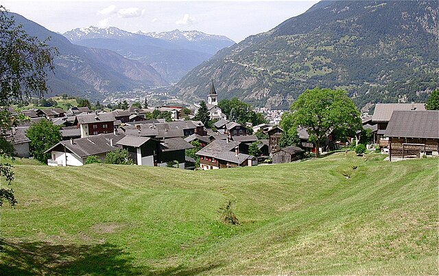
Naters (Naters)

- municipality in the canton of Valais, Switzerland
 Hiking in Naters
Naters is a picturesque municipality in the Valais region of Switzerland, located near the popular tourist destination of Brig. The area offers a variety of hiking opportunities, suitable for different skill levels and preferences. Here are some highlights and tips for hiking in Naters:
Scenic Trails
-
Brig-Naters Hiking Trail: This is a well-marked and easy trail that connects Brig and Naters, providing stunning views of the surrounding mountains and valleys. It’s suitable for families and beginners.
-
Hiking up to the Chamois: For those seeking a moderate hike, trails lead up to areas where you might catch glimpses of local wildlife, including chamois. The routes often feature beautiful alpine meadows.
-
Alpine Trails: More experienced hikers can explore alpine trails that take you higher into the mountains, providing breathtaking panoramic views of the Valais Alps.
Points of Interest
-
Stockalper Palace: Before or after your hike, consider visiting the historic Stockalper Palace in Brig, a beautiful baroque building surrounded by lush gardens.
-
Viewing Points: Many trails lead to viewing platforms that showcase the impressive scenery of the Aletsch Glacier and surrounding peaks, recognized as a UNESCO World Heritage site.
Practical Tips
-
Trail Conditions: Always check the current trail conditions and weather forecasts before heading out, as alpine weather can change rapidly.
-
Equipment: Wear sturdy hiking boots, and dress in layers to accommodate changes in temperature. Don’t forget to bring plenty of water and snacks!
-
Maps and Guides: While trails are marked, it's advisable to carry a map or use a hiking app to ensure you stay on track.
-
Local Guidance: If you’re not familiar with the area, consider joining a guided hiking tour. Local guides can provide insights into the culture and ecology of the region.
Accessibility
Naters can be reached by train or car, and there are public transport options available to access trailheads. The region is generally well-connected, allowing easy access to different trailheads.
Naters offers a beautiful setting for outdoor enthusiasts, combining stunning landscapes with well-maintained hiking paths. Enjoy your hiking adventure in this lovely part of Switzerland!
- Country:

- Postal Code: 3904
- Local Dialing Code: 027
- Licence Plate Code: VS
- Coordinates: 46° 19' 25" N, 7° 59' 19" E


- GPS tracks (wikiloc): [Link]
- AboveSeaLevel: 2774 м m
- Area: 101.26 sq km
- Population: 9983
- Web site: http://www.naters.ch
- Wikipedia en: wiki(en)
- Wikipedia: wiki(de)
- Wikidata storage: Wikidata: Q67040
- Wikipedia Commons Category: [Link]
- Freebase ID: [/m/0h5cxd]
- GeoNames ID: Alt: [7286610]
- VIAF ID: Alt: [239479400]
- OSM relation ID: [1685345]
- GND ID: Alt: [1002867932]
- MusicBrainz area ID: [9b294f82-e760-41e1-9252-6637e7f85994]
- HDS ID: [2665]
- Swiss municipality code: [6007]
- BabelNet ID: [03576469n]
Shares border with regions:
Termen
- municipality in Switzerland
Hiking in Termen
Termen is a small municipality located in the southern region of Switzerland, known for its beautiful alpine landscapes. While it's not one of the most widely recognized hiking destinations compared to its neighbors, it does offer some excellent opportunities for hikers seeking tranquility and stunning views....
- Country:
- Postal Code: 3912
- Local Dialing Code: 027
- Licence Plate Code: VS
- Coordinates: 46° 19' 0" N, 8° 1' 0" E
- GPS tracks (wikiloc): [Link]
- AboveSeaLevel: 925 м m
- Area: 18.8 sq km
- Population: 913
- Web site: [Link]

Eggerberg
- municipality in Switzerland
Hiking in Eggerberg
Eggerberg, located in the Swiss canton of Valais, offers a variety of hiking opportunities for both beginners and experienced hikers. The region is known for its stunning alpine scenery, with picturesque views of the surrounding mountains and valleys....
- Country:
- Postal Code: 3939
- Local Dialing Code: 027
- Licence Plate Code: VS
- Coordinates: 46° 18' 57" N, 7° 53' 20" E
- GPS tracks (wikiloc): [Link]
- AboveSeaLevel: 1262 м m
- Area: 6.0 sq km
- Population: 340
- Web site: [Link]
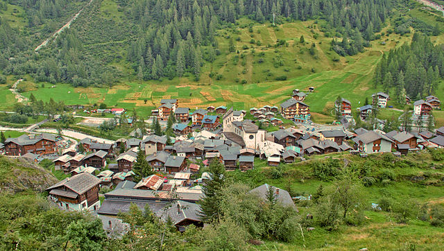

Blatten
- municipality in Switzerland
Hiking in Blatten
Blatten, located in the Lötschen Valley of Switzerland, is a fantastic destination for hiking enthusiasts. This picturesque village is part of the municipality of Naters in the canton of Valais, offering stunning panoramic views of the surrounding mountains....
- Country:
- Postal Code: 3919
- Local Dialing Code: 027
- Licence Plate Code: VS
- Coordinates: 46° 25' 0" N, 7° 49' 0" E
- GPS tracks (wikiloc): [Link]
- AboveSeaLevel: 1542 м m
- Area: 90.63 sq km
- Population: 294
- Web site: [Link]


Bitsch
- municipality in Switzerland
Hiking in Bitsch
Bitsch is a charming village located in the Valais region of Switzerland, nestled in the heart of the Swiss Alps. It's an excellent base for hiking enthusiasts, offering a variety of trails that showcase the stunning natural beauty of the area....
- Country:
- Postal Code: 3982
- Local Dialing Code: 027
- Licence Plate Code: VS
- Coordinates: 46° 20' 0" N, 8° 0' 0" E
- GPS tracks (wikiloc): [Link]
- AboveSeaLevel: 806 м m
- Area: 4.1 sq km
- Population: 976
- Web site: [Link]


Betten
- former municipality of Switzerland
Hiking in Betten
Betten is a picturesque village located in the Valais region of Switzerland, known for its stunning alpine scenery and outdoor activities, including hiking. Here are some key points about hiking in Betten:...
- Country:
- Postal Code: 3991
- Local Dialing Code: 027
- Licence Plate Code: VS
- Coordinates: 46° 22' 0" N, 8° 4' 0" E
- GPS tracks (wikiloc): [Link]
- AboveSeaLevel: 1192 м m
- Area: 26.4 sq km
- Web site: [Link]


Riederalp
- municipality in Switzerland
Hiking in Riederalp
Riederalp, located in the Swiss Alps in the Valais canton, is a fantastic destination for hikers of all skill levels. Nestled at an elevation of about 1,900 meters, it offers stunning views of the surrounding mountains, including the iconic Matterhorn and the Aletsch Glacier, which is the largest glacier in the Alps and a UNESCO World Heritage site....
- Country:
- Postal Code: 3987
- Local Dialing Code: 027
- Licence Plate Code: VS
- Coordinates: 46° 23' 0" N, 8° 2' 0" E
- GPS tracks (wikiloc): [Link]
- AboveSeaLevel: 1905 м m
- Area: 21.04 sq km
- Population: 481
- Web site: [Link]


Fieschertal
- municipality in Switzerland
Hiking in Fieschertal
Fieschertal, located in the Swiss Alps in the municipality of Fiesch, is a picturesque destination for hiking enthusiasts. The region is renowned for its stunning landscapes, lush valleys, and breathtaking mountain views, making it an excellent choice for hikers of all levels....
- Country:
- Postal Code: 3984
- Local Dialing Code: 027
- Licence Plate Code: VS
- Coordinates: 46° 30' 0" N, 8° 8' 0" E
- GPS tracks (wikiloc): [Link]
- AboveSeaLevel: 1108 м m
- Area: 172.96 sq km
- Population: 334
- Web site: [Link]