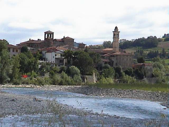
Bettola (Bettola)
.svg)
- Italian comune
 Hiking in Bettola
Bettola is a charming town located in the Emilia-Romagna region of Italy, surrounded by beautiful landscapes that make it a great destination for hiking enthusiasts. Here are some highlights and tips for hiking in and around Bettola:
Hiking Trails
-
Sentiero del Parco: A trail that often leads through scenic woodlands and offers various viewpoints. As part of the Appennino Tosco-Emiliano National Park, it promises stunning natural beauty and diverse flora and fauna.
-
Monte Nero: This hike takes you up to one of the area's higher peaks. The views from the top are breathtaking, especially on clear days, where you can see expansive valleys and hills.
-
Gorge of the Nure River: The trails along the Nure River can be both relaxing and adventurous. You'll encounter waterfalls and unique rock formations.
Tips for Hiking in Bettola
-
Season: Spring and early autumn are ideal times for hiking, as the weather is mild and the flora is vibrant. Summer can be hot, while winter may bring snow, making some trails difficult.
-
Preparation: Pack enough water, snacks, and a first-aid kit. Make sure to wear suitable hiking boots and clothing for the terrain and weather.
-
Trail Maps: It's advisable to have a detailed map or a GPS device, as not all trails are well-marked.
-
Local Advice: Don’t hesitate to ask locals or the tourism office for guidance on trail conditions and recommendations based on your hiking experience.
-
Respect Nature: Keep to marked trails, carry out any trash, and respect wildlife. This ensures the trails remain beautiful and accessible for everyone.
Wildlife and Nature
The area around Bettola is rich in biodiversity. Hikers may come across various wildlife, including deer, foxes, and a variety of bird species. The landscape features beech forests, hills, and rivers, making it a vibrant place for nature lovers.
Conclusion
Bettola offers a lovely mix of natural beauty and cultural experiences. Whether you're looking for a challenging hike or a relaxing stroll through the woods, there are options available for all levels of hikers. Enjoy your adventure in this picturesque part of Italy!
- Country:

- Postal Code: 29021
- Local Dialing Code: 0523
- Licence Plate Code: PC
- Coordinates: 44° 46' 42" N, 9° 36' 31" E


- GPS tracks (wikiloc): [Link]
- AboveSeaLevel: 329 м m
- Area: 122.37 sq km
- Population: 2759
- Web site: http://www.comune.bettola.pc.it
- Wikipedia en: wiki(en)
- Wikipedia: wiki(it)
- Wikidata storage: Wikidata: Q102569
- Wikipedia Commons Category: [Link]
- Freebase ID: [/m/0gkcln]
- GeoNames ID: Alt: [6539637]
- VIAF ID: Alt: [245879708]
- OSM relation ID: [43556]
- MusicBrainz area ID: [d2b1088e-1903-4b91-82d7-a7fd9b43cd3e]
- ISTAT ID: 033004
- Italian cadastre code: A831
Shares border with regions:


Coli, Emilia-Romagna
- Italian comune
Hiking in Coli, Emilia-Romagna
Coli, located in the Emilia-Romagna region of Italy, offers a wealth of hiking opportunities amid stunning landscapes and rich natural diversity. Nestled in the Apennine Mountains, Coli is known for its lush forests, rolling hills, and picturesque views, making it an excellent destination for outdoor enthusiasts....
- Country:
- Postal Code: 29020
- Local Dialing Code: 0523
- Licence Plate Code: PC
- Coordinates: 44° 45' 0" N, 9° 25' 0" E
- GPS tracks (wikiloc): [Link]
- AboveSeaLevel: 638 м m
- Area: 71.69 sq km
- Population: 873
- Web site: [Link]
Farini, Emilia-Romagna
- Italian comune
Hiking in Farini, Emilia-Romagna
Farini is a charming village located in the Emilia-Romagna region of Italy, nestled in the Apennine Mountains. It's an excellent destination for hiking enthusiasts seeking natural beauty, picturesque views, and a peaceful environment....
- Country:
- Postal Code: 29023
- Local Dialing Code: 0523
- Licence Plate Code: PC
- Coordinates: 44° 43' 0" N, 9° 34' 0" E
- GPS tracks (wikiloc): [Link]
- AboveSeaLevel: 424 м m
- Area: 112.36 sq km
- Population: 1198
- Web site: [Link]


Gropparello
- Italian comune
Hiking in Gropparello
Gropparello is a picturesque area located in the Emilia-Romagna region of Italy, known for its beautiful landscapes, historical sites, and outdoor activities, including hiking. The surroundings are characterized by rolling hills, dense forests, and stunning views, making it an ideal spot for nature lovers and hiking enthusiasts....
- Country:
- Postal Code: 29025
- Local Dialing Code: 0523
- Licence Plate Code: PC
- Coordinates: 44° 50' 0" N, 9° 44' 0" E
- GPS tracks (wikiloc): [Link]
- AboveSeaLevel: 355 м m
- Area: 56.33 sq km
- Population: 2268
- Web site: [Link]
Morfasso
- Italian comune
Hiking in Morfasso
Morfasso is a charming village located in the Emilia-Romagna region of Italy, surrounded by picturesque landscapes, forests, and hills. It’s an excellent destination for hiking enthusiasts, offering a variety of trails that cater to different skill levels, from leisurely walks to more challenging treks....
- Country:
- Postal Code: 29020
- Local Dialing Code: 0523
- Licence Plate Code: PC
- Coordinates: 44° 43' 0" N, 9° 42' 0" E
- GPS tracks (wikiloc): [Link]
- AboveSeaLevel: 631 м m
- Area: 83.93 sq km
- Population: 972
- Web site: [Link]


Ponte dell'Olio
- Italian comune
Hiking in Ponte dell'Olio
Ponte dell'Olio is a charming village located in the province of Piacenza, in the Emilia-Romagna region of Italy. Known for its scenic landscapes and rolling hills, it offers various hiking opportunities that cater to different skill levels....
- Country:
- Postal Code: 29028
- Local Dialing Code: 0523
- Licence Plate Code: PC
- Coordinates: 44° 52' 0" N, 9° 38' 0" E
- GPS tracks (wikiloc): [Link]
- AboveSeaLevel: 217 м m
- Area: 43.92 sq km
- Population: 4691
- Web site: [Link]
Travo
- Italian comune
Hiking in Travo
Travo, located in the Corsica region of France, offers a unique blend of scenic beauty, rich history, and outdoor adventures for hiking enthusiasts. Here are some key points about hiking in and around Travo:...
- Country:
- Postal Code: 29020
- Local Dialing Code: 0523
- Licence Plate Code: PC
- Coordinates: 44° 52' 0" N, 9° 33' 0" E
- GPS tracks (wikiloc): [Link]
- AboveSeaLevel: 171 м m
- Area: 81.01 sq km
- Population: 2121
- Web site: [Link]


Vigolzone
- Italian comune
Hiking in Vigolzone
Vigolzone is a charming village located in the Emilia-Romagna region of Italy, offering beautiful landscapes and hiking opportunities for outdoor enthusiasts. Here are some key points about hiking in Vigolzone:...
- Country:
- Postal Code: 29020
- Local Dialing Code: 0523
- Licence Plate Code: PC
- Coordinates: 44° 55' 0" N, 9° 40' 0" E
- GPS tracks (wikiloc): [Link]
- AboveSeaLevel: 151 м m
- Area: 42.04 sq km
- Population: 4294
- Web site: [Link]