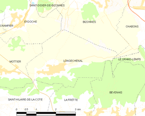
Bizonnes (Bizonnes)

- commune in Isère, France
 Hiking in Bizonnes
Bizonnes is a small commune located in the Auvergne-Rhône-Alpes region of southeastern France, near the city of Grenoble. While it might not be the most prominent destination for hiking, it offers access to picturesque landscapes typical of the region, which is characterized by rolling hills, forests, and stunning views of the surrounding Alps.
Hiking Opportunities:
-
Local Trails: Explore local trails that meander through the countryside, offering beautiful views and the chance to experience the region's flora and fauna. Check with local tourist offices for trail maps and recommendations.
-
Nearby Parks: The proximity to the Vercors Regional Natural Park and the Chartreuse Mountains offers numerous hiking opportunities. These areas are known for their dramatic landscapes, limestone cliffs, and well-maintained trails suitable for various skill levels.
-
Alpine Trails: For more experienced hikers, the higher altitude trails in the nearby Alps provide a chance to tackle more challenging routes with breathtaking panoramas.
Preparation:
- Weather: Before heading out, check the weather conditions, as they can change quickly in the mountains.
- Equipment: Wear sturdy hiking boots and bring plenty of water, snacks, and a map or GPS device.
- Safety: It's important to let someone know your route and expected return time, especially when hiking in remote areas.
Local Insights:
- Scenic Views: Look for spots that offer great viewpoints, particularly in the late afternoon when the light can create stunning landscapes.
- Wildlife: Keep an eye out for local wildlife, including various bird species, deer, and wildflowers.
In summary, while Bizonnes itself may not be a major hiking destination, it serves as a gateway to beautiful hiking experiences in the surrounding regions. Be sure to explore and enjoy the natural beauty of the area!
- Country:

- Postal Code: 38690
- Coordinates: 45° 27' 18" N, 5° 22' 49" E


- GPS tracks (wikiloc): [Link]
- Area: 11.04 sq km
- Population: 926
- Web site: http://www.bizonnes.fr
- Wikipedia en: wiki(en)
- Wikipedia: wiki(fr)
- Wikidata storage: Wikidata: Q1004375
- Wikipedia Commons Category: [Link]
- Freebase ID: [/m/03g_6_h]
- GeoNames ID: Alt: [6455080]
- SIREN number: [213800469]
- BnF ID: [152578751]
- VIAF ID: Alt: [242753985]
- INSEE municipality code: 38046
Shares border with regions:


Eydoche
- commune in Isère, France
Hiking in Eydoche
It seems like there may be a typographical error in your question, as there is no well-known location called "Eydoche." However, if you meant "Eidoche," "Eidolons," or another similar-sounding name, it's possible it refers to a specific area or national park that's less commonly known....
- Country:
- Postal Code: 38690
- Coordinates: 45° 26' 29" N, 5° 19' 51" E
- GPS tracks (wikiloc): [Link]
- AboveSeaLevel: 629 м m
- Area: 5.58 sq km
- Population: 524
- Web site: [Link]


Châbons
- commune in Isère, France
Hiking in Châbons
Châbons is a charming town located in the Isère department of the Auvergne-Rhône-Alpes region in southeastern France. It's surrounded by beautiful landscapes and offers various hiking opportunities suitable for different levels of experience. Here are some highlights regarding hiking in and around Châbons:...
- Country:
- Postal Code: 38690
- Coordinates: 45° 26' 38" N, 5° 25' 51" E
- GPS tracks (wikiloc): [Link]
- Area: 18.14 sq km
- Population: 2098
- Web site: [Link]


Saint-Didier-de-Bizonnes
- commune in Isère, France
Hiking in Saint-Didier-de-Bizonnes
Saint-Didier-de-Bizonnes is a charming village located in the Auvergne-Rhône-Alpes region of France, surrounded by beautiful natural landscapes that are ideal for hiking. Here are some highlights for hiking enthusiasts in the area:...
- Country:
- Postal Code: 38690
- Coordinates: 45° 28' 2" N, 5° 21' 4" E
- GPS tracks (wikiloc): [Link]
- Area: 7.2 sq km
- Population: 294
- Web site: [Link]

Longechenal
- commune in Isère, France
Hiking in Longechenal
Longechenal is a beautiful destination for hiking enthusiasts, located in the picturesque region of Auvergne-Rhône-Alpes in France. Known for its stunning landscapes, diverse terrain, and charming rural atmosphere, this area offers a variety of hiking trails that cater to different levels of experience....
- Country:
- Postal Code: 38690
- Coordinates: 45° 25' 8" N, 5° 20' 52" E
- GPS tracks (wikiloc): [Link]
- Area: 8.12 sq km
- Population: 565


Montrevel
- commune in Isère, France
Hiking in Montrevel
Montrevel is located in the Isère department of the Auvergne-Rhône-Alpes region in southeastern France. It is a beautiful area for hiking, known for its diverse landscapes that combine mountains, valleys, forests, and rivers. Here are some highlights and tips for hiking in the Montrevel area:...
- Country:
- Postal Code: 38690
- Coordinates: 45° 28' 44" N, 5° 24' 8" E
- GPS tracks (wikiloc): [Link]
- Area: 9.37 sq km
- Population: 461
- Web site: [Link]


Belmont
- commune in Isère, France
Hiking in Belmont
Belmont is a picturesque village located in the Isère department of the Auvergne-Rhône-Alpes region in southeastern France. It offers a variety of hiking opportunities that cater to different skill levels and preferences. Here are some highlights and tips for hiking in and around Belmont:...
- Country:
- Postal Code: 38690
- Coordinates: 45° 28' 25" N, 5° 21' 49" E
- GPS tracks (wikiloc): [Link]
- AboveSeaLevel: 550 м m
- Area: 6.51 sq km
- Population: 582