Eydoche (Eydoche)

- commune in Isère, France
 Hiking in Eydoche
It seems like there may be a typographical error in your question, as there is no well-known location called "Eydoche." However, if you meant "Eidoche," "Eidolons," or another similar-sounding name, it's possible it refers to a specific area or national park that's less commonly known.
If you're looking for hiking information in a region that sounds similar, I recommend checking the exact spelling of the location. Alternatively, if you're interested in hiking in a specific country or region (like the Alps, Rockies, or Appalachian Trail), please provide more details, and I'd be glad to help!
In general, when planning a hike, consider the following:
- Trail Difficulty: Assess the level of difficulty to match your skill level.
- Weather Conditions: Always check the weather forecast before heading out.
- Gear: Ensure you have appropriate gear, including sturdy shoes, hydration packs, and possibly trekking poles.
- Maps and Navigation: Use maps or GPS for navigation, especially in less marked trails.
- Safety: Inform someone of your plans and review safety protocols.
Let me know how I can assist you further!
- Country:

- Postal Code: 38690
- Coordinates: 45° 26' 29" N, 5° 19' 51" E


- GPS tracks (wikiloc): [Link]
- AboveSeaLevel: 629 м m
- Area: 5.58 sq km
- Population: 524
- Web site: http://www.eydoche.fr
- Wikipedia en: wiki(en)
- Wikipedia: wiki(fr)
- Wikidata storage: Wikidata: Q1002682
- Wikipedia Commons Category: [Link]
- Freebase ID: [/m/03nvjs1]
- GeoNames ID: Alt: [6433196]
- SIREN number: [213801590]
- BnF ID: [152579817]
- INSEE municipality code: 38159
Shares border with regions:


Bizonnes
- commune in Isère, France
Hiking in Bizonnes
Bizonnes is a small commune located in the Auvergne-Rhône-Alpes region of southeastern France, near the city of Grenoble. While it might not be the most prominent destination for hiking, it offers access to picturesque landscapes typical of the region, which is characterized by rolling hills, forests, and stunning views of the surrounding Alps....
- Country:
- Postal Code: 38690
- Coordinates: 45° 27' 18" N, 5° 22' 49" E
- GPS tracks (wikiloc): [Link]
- Area: 11.04 sq km
- Population: 926
- Web site: [Link]


Saint-Didier-de-Bizonnes
- commune in Isère, France
Hiking in Saint-Didier-de-Bizonnes
Saint-Didier-de-Bizonnes is a charming village located in the Auvergne-Rhône-Alpes region of France, surrounded by beautiful natural landscapes that are ideal for hiking. Here are some highlights for hiking enthusiasts in the area:...
- Country:
- Postal Code: 38690
- Coordinates: 45° 28' 2" N, 5° 21' 4" E
- GPS tracks (wikiloc): [Link]
- Area: 7.2 sq km
- Population: 294
- Web site: [Link]

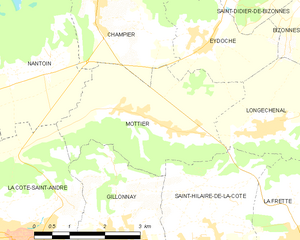
Mottier
- commune in Isère, France
Hiking in Mottier
Mottier, located in the beautiful area of Isère in the French Alps, offers a variety of hiking opportunities that cater to different skill levels and preferences. The surrounding landscape is characterized by stunning mountain views, diverse flora and fauna, and picturesque trails that are perfect for both day hikes and longer excursions....
- Country:
- Postal Code: 38260
- Coordinates: 45° 25' 8" N, 5° 19' 2" E
- GPS tracks (wikiloc): [Link]
- Area: 10.72 sq km
- Population: 690
- Web site: [Link]

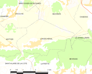
Longechenal
- commune in Isère, France
Hiking in Longechenal
Longechenal is a beautiful destination for hiking enthusiasts, located in the picturesque region of Auvergne-Rhône-Alpes in France. Known for its stunning landscapes, diverse terrain, and charming rural atmosphere, this area offers a variety of hiking trails that cater to different levels of experience....
- Country:
- Postal Code: 38690
- Coordinates: 45° 25' 8" N, 5° 20' 52" E
- GPS tracks (wikiloc): [Link]
- Area: 8.12 sq km
- Population: 565


Flachères
- commune in Isère, France
Hiking in Flachères
Flachères is a small village in the Auvergne-Rhône-Alpes region of France, which offers access to beautiful natural landscapes that are ideal for hiking. While Flachères itself might not be a hiking hotspot, its proximity to the surrounding areas, such as the Vercors and the Chartreuse Mountains, presents excellent opportunities for outdoor activities....
- Country:
- Postal Code: 38690
- Coordinates: 45° 28' 12" N, 5° 18' 49" E
- GPS tracks (wikiloc): [Link]
- Area: 4.94 sq km
- Population: 516
- Web site: [Link]


Champier
- commune in Isère, France
Hiking in Champier
Champier is a charming village located in the Auvergne-Rhône-Alpes region of France, nestled near the northern edge of the Dauphiné region. While it might not be as famous as some larger locales, it offers a variety of beautiful hiking opportunities through picturesque landscapes that showcase the natural beauty of the area....
- Country:
- Postal Code: 38260
- Coordinates: 45° 27' 12" N, 5° 17' 28" E
- GPS tracks (wikiloc): [Link]
- Area: 14.43 sq km
- Population: 1387
- Web site: [Link]