Boara Pisani (Boara Pisani)
- Italian comune
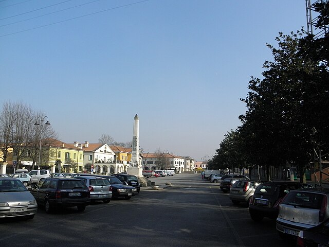
Boara Pisani is a small town located in the Veneto region of Italy, near the Po River. While it may not be widely recognized as a hiking destination, the surrounding areas offer some opportunities for exploration and experiencing the natural beauty of the region.
Hiking Opportunities:
-
Surrounding Countryside: The countryside around Boara Pisani features flat terrain typical of the Veneto Plain, making it suitable for leisurely walks and hikes through agricultural landscapes and along the Po River.
-
Natural Reserves: Nearby, you can find nature reserves and parks, such as the Parco Regionale del Delta del Po. This park offers various trails along the river and through wetlands, where you can observe local wildlife, including birds and other animals.
-
Cultural Walks: Consider hiking routes that connect to nearby towns and landmarks, allowing you to combine hiking with cultural experiences. You might pass through charming villages with historical architecture, local farms, and vineyards.
Practical Hiking Tips:
-
Seasons: The best times to hike in this area are during spring (April to June) and fall (September to October) when the weather is mild and pleasant.
-
Trail Maps: It's a good idea to consult local maps or guides for marked hiking trails, as well as check for any regional parks that may have specific routes.
-
Safety: Always let someone know your planned route and estimated return time. Bring plenty of water and snacks, wear appropriate footwear, and consider sun protection and insect repellent.
-
Local Regulations: Familiarize yourself with any local regulations regarding hiking, especially in protected areas.
Conclusion:
While Boara Pisani itself may not have significant hiking trails, its location allows for easy access to the natural beauty of the Veneto region. Enjoy your hikes by exploring the countryside, engaging with local culture, and appreciating the serene landscapes that Italy has to offer.
- Country:

- Postal Code: 35040
- Local Dialing Code: 0425
- Licence Plate Code: PD
- Coordinates: 45° 6' 28" N, 11° 46' 57" E


- GPS tracks (wikiloc): [Link]
- AboveSeaLevel: 7 м m
- Area: 16.66 sq km
- Population: 2493
- Web site: http://www.comune.boarapisani.pd.it/
- Wikipedia en: wiki(en)
- Wikipedia: wiki(it)
- Wikidata storage: Wikidata: Q34361
- Wikipedia Commons Category: [Link]
- Freebase ID: [/m/0gk3zp]
- GeoNames ID: Alt: [6543572]
- VIAF ID: Alt: [240582129]
- OSM relation ID: [44256]
- GND ID: Alt: [7650084-6]
- UN/LOCODE: [ITBP2]
- ISTAT ID: 028012
- Italian cadastre code: A906
Shares border with regions:


Pozzonovo
- Italian comune
Pozzonovo is a small town located in the Veneto region of Italy, surrounded by beautiful landscapes and a rich natural environment. While it may not be a prominent hiking destination like the nearby Dolomites, there are still some pleasant walking and hiking opportunities in and around Pozzonovo....
- Country:

- Postal Code: 35020
- Local Dialing Code: 0429
- Licence Plate Code: PD
- Coordinates: 45° 12' 0" N, 11° 47' 0" E


- GPS tracks (wikiloc): [Link]
- AboveSeaLevel: 6 м m
- Area: 24.48 sq km
- Population: 3571
- Web site: [Link]


Stanghella
- Italian comune
Stanghella is a small town located in the Province of Padua, in the Veneto region of Italy. While it may not be as famous for hiking as other regions of Italy, it offers some opportunities for those who enjoy walking and exploring nature....
- Country:

- Postal Code: 35048
- Local Dialing Code: 0429; 0425
- Licence Plate Code: PD
- Coordinates: 45° 8' 0" N, 11° 45' 0" E


- GPS tracks (wikiloc): [Link]
- AboveSeaLevel: 7 м m
- Area: 19.81 sq km
- Population: 4156
- Web site: [Link]


Anguillara Veneta
- Italian comune
Anguillara Veneta is a charming town located in the province of Padua in the Veneto region of Italy. While it may not be as famous for hiking as some of the larger mountain ranges in Italy, it offers some delightful trails and scenic spots for those looking to enjoy nature and the surrounding countryside....
- Country:

- Postal Code: 35022
- Local Dialing Code: 049
- Licence Plate Code: PD
- Coordinates: 45° 9' 0" N, 11° 53' 0" E


- GPS tracks (wikiloc): [Link]
- AboveSeaLevel: 6 м m
- Area: 21.67 sq km
- Population: 4325
- Web site: [Link]


Vescovana
- comune of Italy
Vescovana is a charming village located in the Veneto region of Italy, known for its picturesque landscapes and rich cultural heritage. While Vescovana itself may not be widely recognized for extensive hiking trails, it offers a great starting point for exploring the surrounding areas....
- Country:

- Postal Code: 35040
- Local Dialing Code: 0425
- Licence Plate Code: PD
- Coordinates: 45° 8' 0" N, 11° 43' 0" E


- GPS tracks (wikiloc): [Link]
- AboveSeaLevel: 7 м m
- Area: 22.25 sq km
- Population: 1810
- Web site: [Link]


Rovigo
- Italian comune
Rovigo, located in the Veneto region of Italy, is not as widely recognized for hiking compared to other parts of the country. However, it offers some lovely trails and natural areas that can be appealing for those looking to explore the outdoors....
- Country:

- Postal Code: 45100
- Local Dialing Code: 0425
- Licence Plate Code: RO
- Coordinates: 45° 4' 0" N, 11° 47' 0" E


- GPS tracks (wikiloc): [Link]
- AboveSeaLevel: 7 м m
- Area: 108.81 sq km
- Population: 51625
- Web site: [Link]

