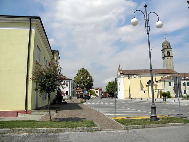
Stanghella (Stanghella)
- Italian comune
Stanghella is a small town located in the Province of Padua, in the Veneto region of Italy. While it may not be as famous for hiking as other regions of Italy, it offers some opportunities for those who enjoy walking and exploring nature.
Here are a few aspects to consider for hiking in and around Stanghella:
1. :
Stanghella is surrounded by a largely flat landscape, characterized by agricultural fields and the presence of the Adige River. There are several local paths and trails that can be explored, particularly if you enjoy flat terrain and scenic countryside views.
2. :
While Stanghella itself does not have large parks, you can explore nearby areas such as:
- Parco Regionale dei Colli Euganei: About a 30-minute drive from Stanghella, this regional park provides a variety of hiking trails through wooded hills and vineyards. The area is also known for its thermal springs and beautiful views.
- Parco del Delta del Po: Located a bit further away, this nature reserve is where the Po River meets the Adriatic Sea. It offers trails and bird-watching opportunities amidst unique wetlands.
3. :
In addition to hiking, you can combine your outdoor experience with visits to local historical sites. Exploring the town and surrounding areas might provide insights into the culture and history of the Veneto region.
4. :
The ideal times for hiking in this area are spring (April to June) and autumn (September to October) when the weather is mild and the scenery is beautiful. Summers can be hot, and winter may bring cold temperatures.
5. :
- Footwear: Make sure to wear comfortable, sturdy hiking shoes.
- Hydration: Always carry enough water, especially on warmer days.
- Maps: While it’s good to have a GPS, bringing a physical map can be helpful in less populated areas.
Conclusion:
While Stanghella may not be a hiking hotspot, it can serve as a pleasant gateway to exploring the natural beauty and trails of the Veneto region. Be sure to enjoy the local landscapes, cuisine, and culture as you embark on your hiking adventures!
- Country:

- Postal Code: 35048
- Local Dialing Code: 0429; 0425
- Licence Plate Code: PD
- Coordinates: 45° 8' 0" N, 11° 45' 0" E


- GPS tracks (wikiloc): [Link]
- AboveSeaLevel: 7 м m
- Area: 19.81 sq km
- Population: 4156
- Web site: http://www.comune.stanghella.pd.it
- Wikipedia en: wiki(en)
- Wikipedia: wiki(it)
- Wikidata storage: Wikidata: Q34364
- Wikipedia Commons Category: [Link]
- Freebase ID: [/m/0gk5n8]
- GeoNames ID: Alt: [6538344]
- VIAF ID: Alt: [149100077]
- OSM relation ID: [44311]
- GND ID: Alt: [4448850-6]
- WOEID: [724510]
- Quora topic ID: [Stanghella]
- TGN ID: [1046998]
- UN/LOCODE: [ITSHL]
- ISTAT ID: 028088
- Italian cadastre code: I938
Shares border with regions:


Pozzonovo
- Italian comune
Pozzonovo is a small town located in the Veneto region of Italy, surrounded by beautiful landscapes and a rich natural environment. While it may not be a prominent hiking destination like the nearby Dolomites, there are still some pleasant walking and hiking opportunities in and around Pozzonovo....
- Country:

- Postal Code: 35020
- Local Dialing Code: 0429
- Licence Plate Code: PD
- Coordinates: 45° 12' 0" N, 11° 47' 0" E


- GPS tracks (wikiloc): [Link]
- AboveSeaLevel: 6 м m
- Area: 24.48 sq km
- Population: 3571
- Web site: [Link]


Boara Pisani
- Italian comune
Boara Pisani is a small town located in the Veneto region of Italy, near the Po River. While it may not be widely recognized as a hiking destination, the surrounding areas offer some opportunities for exploration and experiencing the natural beauty of the region....
- Country:

- Postal Code: 35040
- Local Dialing Code: 0425
- Licence Plate Code: PD
- Coordinates: 45° 6' 28" N, 11° 46' 57" E


- GPS tracks (wikiloc): [Link]
- AboveSeaLevel: 7 м m
- Area: 16.66 sq km
- Population: 2493
- Web site: [Link]


Granze
- Italian comune
It appears there's a slight confusion with the name "Granze." If you're referring to a specific hiking location, it might not be widely recognized or could be a misspelling. However, if you meant "Granz" in Austria or "Grenze" in a general sense, I can provide some useful insights....
- Country:

- Postal Code: 35040
- Local Dialing Code: 0429
- Licence Plate Code: PD
- Coordinates: 45° 11' 0" N, 11° 43' 0" E


- GPS tracks (wikiloc): [Link]
- AboveSeaLevel: 6 м m
- Area: 11.47 sq km
- Population: 2032
- Web site: [Link]


Vescovana
- comune of Italy
Vescovana is a charming village located in the Veneto region of Italy, known for its picturesque landscapes and rich cultural heritage. While Vescovana itself may not be widely recognized for extensive hiking trails, it offers a great starting point for exploring the surrounding areas....
- Country:

- Postal Code: 35040
- Local Dialing Code: 0425
- Licence Plate Code: PD
- Coordinates: 45° 8' 0" N, 11° 43' 0" E


- GPS tracks (wikiloc): [Link]
- AboveSeaLevel: 7 м m
- Area: 22.25 sq km
- Population: 1810
- Web site: [Link]


Solesino
- Italian comune
Solesino, located in the Veneto region of northern Italy, is surrounded by scenic landscapes that offer a variety of hiking opportunities. While it may not be as widely known as some larger destinations, it provides beautiful trails that showcase the natural beauty of the area....
- Country:

- Postal Code: 35047
- Local Dialing Code: 0429
- Licence Plate Code: PD
- Coordinates: 45° 10' 0" N, 11° 45' 0" E


- GPS tracks (wikiloc): [Link]
- AboveSeaLevel: 10 м m
- Area: 10.14 sq km
- Population: 7025
- Web site: [Link]

